Sculptural uses of Sydney sandstone make aesthetic and symbolic use of the material's connection with Sydney's geology . This beautiful piece is located at the end of Playfair Street, near where it meets George Street in The Rocks area of Sydney. This area that teems with people every weekend when The Rocks Markets take place.

The geological significance is that the sculptor appears to have chosen blocks which illustrate the wide variety of structure within the LOCAL rock.
Look closely at blocks and they will show us the how and where they were laid down.
"First Impressions" is made from Sydney sandstone which is the common name for Hawkesbury Sandstone, one variety of which is historically known as “Yellowblock”, a sedimentary rock named after the Hawkesbury River, north of Sydney, where this sandstone is particularly common. However, most rocks you see locally are weathered, that is worn, stained, or warped by exposure to wind, rain and sun etc.
The sculpture's value as an earthcache is that it shows freshly hewn, unweathered examples of "Yellowblock" or Hawkesbury sandstone.
Six kilometres of sandstone and shale lie under Sydney. In Sydney sandstone, the ripple marks from the ancient river that brought the grains of sand are distinctive and easily seen, telling geologists that the sand comes from rocks formed between 500 to 700 million years ago far to the south in Antarctic regions
Sedimentary rocks are formed from sediments that have settled at the bottom of a lake, sea or ocean, and have been compressed over millions of years. The sediment comes from eroded rocks carried there by rivers.Over millions of years these sands were consolidated into sandstone. It is composed of very pure silica grains and a small amount of the iron mineral siderite in varying proportions, bound with a clay matrix. It oxidises to the warm yellow-brown colours that are notable in the buildings which are constructed of it.
It was a highly favoured building material, especially preferred during the city's early years—from the late 1790s to the 1890s, gives the city its distinctive appearance. The first occupants hewed out sandstone from the outcrops and built simple houses. Convicts were also employed tunneling through what is called the 'Argyle Cut' in The Rocks. (Up-hill about 100 metres from where you stand)
Textbook diagrams explaining sedimentary rocks show beautiful neat layers of sand, laid out horizontally, but more usually sandstone is laid down, like Sydney's, in river deltas where the sand is moved, sorted, shoved and pushed before it is buried.
There are few neat horizontal layers in this type of sandstone. Only when sand is left behind in the old stream beds it is purer than usual, lower in clays and iron.
Rivers and streams carry large amounts of material, such as soil and rock. You can sometimes find the direction of flow of the ancient river channels in one bed. The bigger chunks are often at one end and fine mud at the other. The big stuff drops out of the flow as the speed of the water decreases. Usually the finer material gets washed further down stream
Cross beds can tell geologists much about what an area was like in ancient times. The direction the beds are sloping indicates the ancient current, the rough direction of sediment transport. The type and condition of sediments can tell geologists the type of environment (rounding, sorting, composition). Studying these rocks allows geologists to draw conclusions about ancient environments.
This yellowblock is strongly bonded, with less clay to weaken and give way. A filled river bed of pure sand makes a fine hard rock, smooth on the surface, free of the ironstone contortions that may be seen. The Eora people of the Sydney region knew this good sandstone when they saw it, just as a modern artist recognises a good canvas.
Traces of impurities are visible in the sandstone. A few bits of plant stems or leaves, or a tiny dead animal are all the impurities you need to get started, along with a bit of rust.
In some basic chemistry the rust is reduced to soluble ferrous iron which seeps slowly through the rock until it is oxidised again to ferric iron. This chemistry can make spheres of tough iron-rich stone, deep inside the sandstone.
Uncovered, they may make fantastic patterns in the stone, for the spheres are eventually revealed as complex rings and ovals of tougher, more resistant rock, etched and ridged and sculpted into the surface of the stone.
Most remarkable in some of this sandstone are bands of colour. These hues found in these sandstone formations commonly feature deep reds, oranges, and yellows. In some locations, these colours alternate in beautiful banded patterns, which resulted from rapid changes in the surrounding environment. That is an inundation of different material for some reason, a flood, or just seasonal weather change etc .
VISIT THE SITE, STAND AT THE GIVEN COORDINATES
Your Task
CONSIDER THE QUESTIONS and then message, or email us your responses. Go ahead and log your find,
PLEASE don't put answers in your log. I will you contact ASAP either through the message centre or email.
PROCEDURE
* Identify one of the three faces, eg. the “Settlers” side.
* State whether the block(s) you are choosing is on the left or right as you look at the face.
* Count up from the bottom, being #1 etc,
* You can USE the illustration below, to identify particular blocks
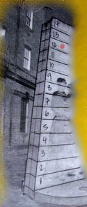
* Using the red spot as an example -It is placed on the Settler side/face // left handside // Block #12
LOGGING TASKS
REMINDER~PLEASE MESSAGE OR EMAIL US THE RESPONSE. DO NOT POST IT IN YOUR LOG. THANKS
Avoiding the face pictured above, if possible. Which face, left or right side and which EACH block illustrates. You will need FIVE individual locations.
1. An inclusion, larger than a $2 coin, ( a bit of other rock material included, which doesn't seem to belong)
2. A characteristic current bedding or cross-bedding ( horizontal units that are internally composed of inclined layers)
3 . A block which was formed in a stream/ river bed , and has no impurities
4. A block that illustrates rapid changes in in the surrounding environment
5. Ripple marks ie beds not laid down horizontally
By all means post photos but avoid photos which would allow people to complete this cache without actually visiting
INDIVIDUAL RESPONSES ARE REQUIRED ~ GROUP RESPONSES WILL NOT BE ACCEPTED
IF YOU DO NOT COMPLETE THE LOGGING REQUIREMENTS YOUR LOG WILL BE DELETED WITHOUT NOTICE
Congratulations to JordsAU and Morry9 for good answers and joint FTF