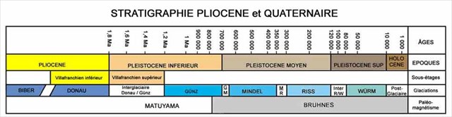
Le quaternaire a été marqué par une succession de glaciations qui ont conduit les glaciers des Alpes à faire des avancées spectaculaires vers les plaines, atteignant Lyon et la vallée du Rhône. Et dépassant même le lit du fleuve actuel vers l’ouest, entre Lyon et Vienne.

Ci-dessus figure en blanc l’avancée la plus forte qui a eu lieu pendant la période glaciaire du Riss (-200000 ans). Au Würm, l’avancée approcha de 20 km le confluent du Rhône et de la Saône (ligne marron). Le repérage de ces mouvements glaciaires a été possible en analysant sur le terrain les avancées extrêmes des moraines (moraine frontale).
Les Grandes Terres sur lesquelles se situe cette earthcache (triangle orange) ont été submergées et façonnées par les glaces, au moment du Riss, le glacier jouant le rôle d’un gigantesque rabot. Les paysages ont été modulés et lissés par ces avancées imposantes, dans le sens est-ouest (avancée du glacier) puis ouest-est (retrait du glacier).
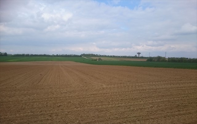
La forme des paysages, formés de plaines au relief peu accentué en est déjà un témoignage. Les glaces se retirant, le paysage continua d’être érodé par l’action des torrents dus à la fonte des glaces, qui déposèrent des sédiments. Les dépôts, dû aussi bien aux glaciers qu’eaux de fonte, constituent une mémoire qui nous livre l’histoire de ces paysages.
En vous rendant aux coordonnées de l’earthcache, vous trouverez un panneau où sont exposées 4 véritables carottes ou échantillons, extraites du sol à différentes profondeurs. Ces carottes sont supposées stratigraphiquement représentatives c'est-à-dire non perturbées depuis leur formation.
Pour répondre à l’earthcache :
- Question 1 : Vous trouverez sur le panneau une petite carte des Grandes Terres. Le lieu où nous sommes (cercle bleu) correspond-t-il à du Riss ancien ? Riss récent ? du Würm ?
- Question 2 : Observer les échantillon n° 2 et 3. Ils montrent des alluvions fluvio-glaciaires
a/ Donner une définition de la farine glaciaire
b/ La farine entoure des blocs erratiques.
Pour quel échantillon (2 ou 3) ces blocs sont-ils les plus gros et plus poli ? D’où viennent ces différences ?
c/ La couleur de l’échantillon 2 témoigne de son ancienneté et traduit sa richesse en …………... ? ( mots manquants)
- Question 3 : Le sol actuel des Grandes Terres (échantillon 1) est couvert d’une couche spéciale.
a/ Quel est son nom ?
b/ Qui a amené cette couche fertile ?
c/ Citer 4 minéraux la constituant ?
Sources : http://morphoglaciaire.free.fr/site_source/Pour_en_savoir_plus/wexp0001.htm
Remarque : l'earthcache se trouve sur le très beau circuit "Le Grand Tour" de Marzack, entre les caches 6 et 7.
Rappel concernant les Earthcaches : il n'y a pas de contenant à trouver ni de logbook à signer.
Loguez un "found it" et envoyez-moi vos réponses soit via mon profil, soit via la messagerie du site. Je vous contacterai en cas de problème.
Tout log enregistré sans envoi des réponses sera supprimé.
-------------------------------------------------------------------------------------------------------------------------------------------------------------
The Quaternary was marked by a succession of glaciations which led the glaciers of the Alpsto make spectacular movements towards plains, achieving to Lyon and the valley of the Rhône. And exceeding even the bed of the current river westward, between Lyon and Vienna.
Above represents in white the strongest advance which took place during the glacial period of Riss (200000 years). In Würm, the advance approached 20 km the confluence of the Rhône and the Saône (line brown). The location of these glacial advances was possible by analyzing on the ground the extreme advances of moraines (frontal moraine).
Big Earth on which is situated this earthcache (triangle orange) were submerged and shaped by ices, at the time of Riss, the glacier playing the role of a gigantic plane. The landscapes were modulated and smoothed by these impressive advances, in the east-west sense (moved forward by the glacier) then the West is (retreat of the glacier).
The form of the landscapes, formed from plains to the little stressed relief is there already a testimony. Ices withdrawing, the landscape continued to be affected by the action of torrents due to the cast iron of ices, which put down sediments. The deposits, owed as well to the glaciers as the waters of cast iron, establish a memory which delivers us the history of these landscapes.
By returning you to the address and phone number of the earthcache, you will find a panel where are exposed 4 true carrots or samples, extracted from the ground with various depths. These carrots are supposed stratigraphically representative that is no disrupted since their training.
To answer the earthcache:
- Question 1: you will find on the panel a small card of Big Earth. The place where we are (circle blue) does he correspond to former Riss? Riss recent? Of Würm?
- Question 2: observe sample N 2 and 3. They show fluvio-glacial alluviums
a/ Give a definition of the glacial flour
b / The flour surrounds erratic blocks.
For what sample (2 or 3) are these blocks the biggest and done more polished ? Where from come these differences?
c/ The color of the sample 2 shows of its seniority and translates its wealth … … … …... (Missing words)
- Question 3: the current ground of Big Earth (sample 1) is covered with a special layer.
a/ What is its name?
b/ Who brought this fertile layer?
c/ to Quote 4 minerals establishing her?
Sources : http://morphoglaciaire.free.fr/site_source/Pour_en_savoir_plus/wexp0001.htm
Remark: the earthcache is on the very beautiful circuit " The Big Tour " of Marzack, between hiding places 6 and 7.
Reminder concerning Earthcaches: there is not of containing neither to find nor of logbook to sign.
Loguez one "found it" and send me your answers either via my profile, or via the messaging of the site. I shall contact you in case of problem.
Any log recorded without sending of the answers will be deleted.