
The Maryland Geocaching Society welcomes you to the 2017 edition of Cache Across Maryland! This is one of eleven geocaches placed throughout the ‘Old Line State’ in locations specifically chosen to showcase its diverse beauty. From the mountains of Western Maryland to the wetlands of the Eastern Shore, CAM 2017 will demonstrate that Maryland truly is ‘America in Miniature’.
Each Cache Across Maryland 2017 geocache contains a code which you will use to determine the location of the CAM 2017 Picnic to be held on May 6th. The code can be found on the inside of the cache container and on the inside front cover of the logbook. Don't forget to record this code! Any geocacher who has completed TEN of the eleven CAM 2017 geocaches and attends the CAM Picnic on May 6th will receive a Certificate of Completion and a CAM 2017 Geocoin. We hope you enjoy a very special CAM 2017!

Biscoe Gray Heritage Farm
The History
The Biscoe Gray property was a holding of John Laveille, a French Huguenot who arrived in Calvert County in the late-seventeenth or early-eighteenth century. In 1902 a portion of the site was sold to George E. Rice, an African-American farmer who lived on the property with his wife Mary until 1938. William B. Gray then purchased the property, which was adjacent to his extensive landholdings along Grays Road. Gray’s son, Biscoe Gray, inherited the property in 1947 and, in turn, passed it on to his children, who sold the land to Calvert County in 2004 which purchased it as part of the Rural Legacy Program.
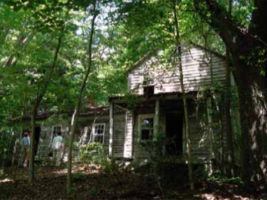
George E. Rice House
Historical Road Trace (Rolling Road)
The road trace that is a major physical feature of the site has existed since at least 1865 but likely was in use as early as ca. 1725 based on evidence of early historic occupations on the property. By 1892 the road took a sharp southeasterly turn toward the unnamed creek, then crossed over the creek to the adjoining Laveille property where it then turned southwesterly to directly meet Battle Creek. As the archaeological report notes, “this arrangement likely indicates the presence of a wharf along Battle Creek immediately south of its confluence with the unnamed stream.”
The historic Rolling Road was a primary transportation route for those who lived on the Biscoe Gray property. More importantly, it was the mechanism for transporting tobacco and other goods to boats on Battle Creek in the eras in which the Creek was still navigable for larger vessels. Specifically, rolling roads were named such because of the practice of loading tobacco in hogsheads (wooden barrels) weighing up to 800 pounds. Sometimes loaded onto carts and sometimes attached to the carts and rolled behind, hogsheads were the primary tobacco packing and transport method until the 1930s. Few rolling roads are accessible or interpreted for the public, underscoring the importance of preserving the Biscoe Gray Rolling Road, maintaining its distinctive physical and experiential presence, and enhancing its interpretive value.
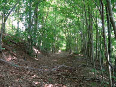
Rolling Road
The Rolling Road is easily discernible along some of its length. The Money Crop Trail, located along the Rolling Road, invites visitors to journey along the same path that farmers used, driving oxen, mules, and horse-drawn carts more than 250 years ago.
Link to Biscoe Gray Heritage Farm:
www.calvertparks.org/bghf.html
Link to trail map:
www.calvertparks.org/Resources/Documents/ParkMaps/BiscoeGrayHeritageFarmMap.pdf
(https://goo.gl/bl0NHp)
The Geocache
This geocache is not located at the listed coordinates. From parking, carefully cross the road, visit the four locations listed below, and do a bit of number pulling to determine the final location.
1. Plumer-Cranford Barn (N38° 29.125', W076° 35.012')
Count the number of vertical boards forming the barn door (hidden by the CAM logo in the image below):

2. Coop Door (N38° 29.063', W076° 35.033')
Count the nails connecting the metal hasp to the coop door (hidden by the CAM logo in the image below):
3. Cow Shed (N38° 29.056', W076° 35.041')
The cow shed is south of the George E. Rice House. Enter the bay on the left and find the window door on the left wall of the shed. The bracing on the window door resembles a letter of the alphabet. Assigning a numerical value to each letter of the alphabet (A=1, B=2, C=3, etc.), what is the value of the letter the bracing resembles?
- CD = two-digit value of the letter formed by the bracing
4. Hill Pole (N38° 28.943', W076° 35.087')
From the cow shed, you can follow parts of the Rolling Road or walk along the fields until you reach the small hill. At the top of the hill, you’ll find a section of grey tubing with ‘GRAY SOUTH’ and three digits stamped on its side.
- EFG = the three digits after ‘GRAY SOUTH’
- H = A+1
The geocache is located at N38° CH.AGG', W076° FB.DEH'
The checksum of A+B+C+D+E+F+G+H is 35
As you make your way to the final location, you can follow parts of the Rolling Road or walk along the edges of the fields. When you reach birdhouse #23, bear left to follow the Farm Trail (red blazes). At no point will bushwhacking be required. The container is hidden about 20 feet from the trail.
The Biscoe Gray Heritage Farm is open from dawn to dusk.
The MGS extends its thanks to the staff of the Biscoe Gray Heritage Farm for permitting and approving this geocache placement.