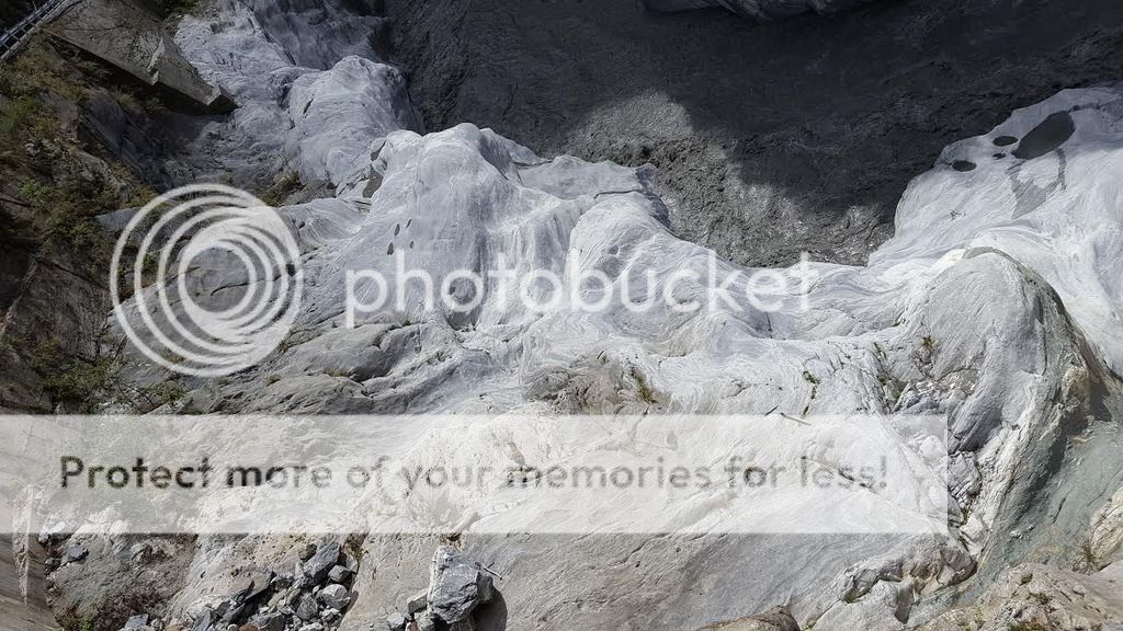
The most phenomenal aspect of the park is the amazing relief. In a single afternoon you can travel from rugged coastal cliffs through a maze of subtropical forested canyons to high elevation subalpine coniferous forests.
The header coordinates are probably the best spot from which to view Taroko Gorge. The marble walls of the gorge tower above you and the water of the Liwu River rushes below. Can you believe that marble used to be coral rock and marine organisms ?
Taroko Gorge represents a canyon up to 800 m deep. The force behind the steep valleys and narrow canyons is a rapid fluvial down-cutting during Pleistocene uplift. The canyon features several characteristics of a neotectonic landform:
1, high rates of uplift resulting from active tectonic setting;
2, intense down-cutting on the floor of the gorge;
3, high strength but vulnerability of denudation of local rock types;
4, high-magnitude climatic events that induce high rates of surface processes.
Over the last 70 million years, these forces collaborated to form the world's deepest marble canyon.
這公園最特殊的地方就是它的神奇立體地貌。 你可以用一個下午時間,從崎嶇 的海岸峭壁穿過迷宮般的亞熱帶森林峽谷到達高海拔的亞高山針葉林。寶頁上的座標應該是觀賞太魯閣最好的地點。 峽谷高聳的大理石峭壁就在你上頭,而同時立霧溪的溪水在你下方沖刷而過。 你能相信這大理石原先是珊瑚礁 和海洋生物嗎?
太魯閣狹谷谷深高達800公尺。 陡峭的山谷和狹窄的峽谷是持續進行的造山運 動以及立霧溪急流下切的強大力量所形成的。 這新形成的狹谷地貌有幾個特徵:
1)活躍的造山運動環境形使得大理岩層不斷隆起升高
2) 河流將山脈岩層切蝕成開闊河谷
3) 岩性質密但郤又易侵蝕的當地岩石特性
4) 極端氣候與地震的影響引發高頻率的地表變化
經歷了七千萬年這些力量的結合,造成了世界最深的大理石狹谷。
Taiwan is geologically active, formed on a complex convergent boundary between the Yangtze Subplate of Eurasian Plate to the west and north, the Okinawa Plate on the north-east, the Philippine Plate on the east and south, and the Sunda Plate to the southwest.
菲律賓海板塊的隱沒方向在台灣改變,在台灣南方,歐亞大陸板塊朝東隱沒到菲律賓海板塊之下,形成馬尼拉海溝及其東側的呂宋火山島弧,到了台灣北方,菲律賓海板塊則是朝北隱沒到歐亞大陸板塊之下,造成琉球海溝及其北側的琉球火山島弧和沖繩海槽.
Taroko Gorge is part of the Central Mountain Range and the rocks are belong to the pre-Tertiary metamorphic complex. Poor quality fossil evidence suggests an origin in the Permian Period. All the rocks in this area are grouped together as the Tananao Schist. This belt is oriented roughly N-S for a distance of cca 250 km and is 30 km wide in the north and narrows to the south. This group consists of Kainanagang Gneiss, Tailuge Marble, and Changchun Schist. A further subdivision of the Tananao Schist group resulted in creation of 2 additional belts and Taroko Gorge lies within the so-called Tailuge belt.
台灣最古老的岩石位於中央山脈東翼,且已經高度變質[. 當地少量的化石可證明其年代在二疊紀。該區岩石從宜蘭縣南澳鄉沿中央山脈東翼延伸至台東縣金峰鄉。該區域北方寬度約 30 公里,並向南逐漸變窄。這些台灣最早期的岩石都已高度變質,且在台灣西部深處也可找到。中央山脈東翼地質區可再分成西側由變質岩綠色片岩形成的太魯閣帶,和東側由變質岩藍片岩組成的玉里帶。
The geology within the belt primarily consists of Permian metamorphic basement including marble, green, black and silicious schists and isolated bodies of gneiss. The marble, which is the predominant rock-type is massive and thickly bedded and there´s extensive jointing and faulting as a result of intense local tectonic deformation.
這兩個變質帶可能由壽豐斷層分隔,但尚未確認。矽質片岩是灰色的,因為變質自砂岩,而富含石英。石英岩和燧石也可找到,而且通常和黑色片岩共生。太魯閣大理岩則北起太魯閣並沿中央山脈東翼直到南橫公路上的台東縣海端鄉霧鹿和關山鎮之間為止。在宜蘭縣蘇澳鎮南方有許多石灰岩採礦場,是水泥工業的原料來源。雖然該區顏色大多是灰色,但也有黑或白色的石灰岩被切碎做為建材之用。白雲石也常和石灰岩共生,尤其在清昌山(又稱千谷寒山)、和平溪和木瓜山。
. Marble is a rock resulting from metamorphism of sedimentary carbonate rocks, most commonly limestone or dolomite rock. Metamorphism causes variable recrystallization of the original carbonate mineral grains. The resulting marble rock is typically composed of an interlocking mosaic of carbonate crystals. Primary sedimentary textures and structures of the original carbonate rock (protolith) have typically been modified or destroyed.
大理岩 是石灰岩或白云岩等受接触、区域变质作用重结晶形成,方解石和白云石的含量一般大于50%,有的达99%。遇盐酸反應產生二氧化碳。大理岩的名称逐渐发展成一切有各种颜色花纹的,用作建筑装饰材料的石灰岩,但制作雕像的白色大理岩也称为大理岩。
Pure white marble is the result of metamorphism of a very pure (silicate-poor) limestone or dolomite protolith. The characteristic swirls and veins of many colored marble varieties are usually due to various mineral impurities such as clay, silt, sand, iron oxides, or chert which were originally present as grains or layers in the limestone. Green coloration is often due to serpentine resulting from originally high magnesium limestone or dolostone with silica impurities. These various impurities have been mobilized and recrystallized by the intense pressure and heat of the metamorphism.
一般大理岩中含有少量的其他变质矿物,由于原来岩石中所含杂质不同(硅质、泥质、碳质、铁质、火山碎屑物质等),及变质作用的温度、压力、水含量等差别,伴生矿物也不同. 由较纯的碳酸盐岩石形成的大理岩中,方解石、白云石占90%以上,有时可含很少的石墨、白云母、磁铁矿、黄铁矿等,在低温高压下方解石可转变成文石. 大理岩一般有典型的粒状变晶结构,颗粒粗细不一。岩石中的方解石、白云石颗粒之间成紧密镶嵌结构。在某些区域变质作用形成的大理岩中,由于方解石的光轴成定向排列,使大理岩具有较强的透光性,有的大理岩可透光2厘米,是优良的雕刻材料。大理岩多为块状构造,也有不少具条带、条纹、斑块或斑点等构造,经过加工后成为有不同颜色和花纹的装饰建筑材料。
大理岩一般是纯白色,白色大理石一般称为汉白玉。有的具各种美丽的颜色和花纹,有浅灰、浅红、浅黄、绿色、褐色、黑色等,原因是大理岩中含有少量的有色矿物和杂质,如含锰方解石的大理岩为粉红色,大理岩中含石墨为灰色,含蛇纹石为黄绿色,含绿泥石、阳起石和透辉石为绿色,含金云母和粒硅镁石为黄色,含符山石和钙铝榴石为褐色等。
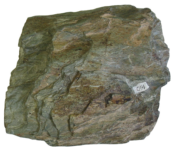
Schist is a medium-grade metamorphic rock with medium to large, flat, sheet-like grains in a preferred orientation (nearby grains are roughly parallel). The schists are classified principally according to the minerals they consist of and on their chemical composition. Most schists are mica schists, but graphite and chlorite schists are also common.
 Greenschists are metamorphic rocks that formed under the lowest temperatures and pressures usually produced by regional metamorphism, typically 300–450 °C and 2–10 kilobars. The name comes from commonly having an abundance of green minerals such as chlorite, serpentine, and epidote, and platy minerals such as muscovite and platy serpentine. The platiness causes the tendency to split, or have schistosity. The rock is derived from basalt, gabbro or similar rocks containing sodium-rich plagioclase feldspar, chlorite, epidote and quartz.
片岩(英语:schist)是具有明显片状构造的变质岩,其变质程度比千枚岩高,几乎所有的原岩物质都已经重结晶,所以颗粒粗大,其颗粒结构主要是石英和长石,石英含量一般比长石多,长石含量常少于25%,其变斑晶为变质矿物,主要有十字石、蓝晶石、夕线石、堇青石、石榴石等。
片岩一般根据其矿物分类和命名,如云母片岩、角闪片岩、绿泥片岩、滑石片岩等。
綠泥石片岩 (chlorite schist): 片理明顯之綠色至暗綠色岩石,呈鱗片狀或鱗片粒狀,有時含有白色條帶。綠泥石片岩可再依其次要礦物分成藍閃石綠泥石片岩、滑石綠泥石片岩及角閃石綠泥石片岩等。臺灣之綠泥石片岩,依其組成礦物之粒度,可分為細粒與中粒兩種。細粒綠泥石片岩又可細分成兩類:(1)等粒形:細粒等粒之綠色岩石,片理甚發達,主要礦物為綠泥石、綠簾石、角閃石、石英、黝簾石及方解石;(2)帶狀型:由方解石、石英及斜長石組成之白色條紋,其綠色部分則由綠泥石及綠簾石組成。而中粒綠泥石片岩亦可細分成兩類:(1)等粒形:呈綠色,具中粒及等粒結構,大部份由綠泥石、綠簾石、方解石、斜長石及石英組成;(2)斑狀形:斑晶礦物主要為石榴子石、電氣石、石英及黃鐵礦等,充填礦物多為綠泥石、石英、綠簾石、絹雲母及鐵礦。
THE CACHE:
As this is a virtual, „Earth cache“-type, don´t look for a physical container. To fulfil the log requirements, however, you have to send me via e-mail or messenger answers to following questions:
1a, At Header coordinates: Look at the cliffs of the gorge in front of you. Can you see any difference between the cliff on the left bank of the river versus the cliff on the right bank ? Estimate, how narrow the gorge is in the part next to the tunnel.
1b, At WP1: Again, look at the left and right side of the gorge (or eastern versus western side). Can you spot any difference compared to what you saw at the header coords ? Why do you think this is the case ?
2, From the 4 characteristic features of a neotectonic landform, which one can you find either at header coordinates or WP1 ? What would be here an example of a "high-magnitude climatic event"?
3, Describe the difference between marble and green schist. What do you think, what forces were responsible for the metamorphic process that created Taroko Gorge marble ? What is the name of the orogeny that started 6 million years ago ?
4, As usual, a photo from the location isn´t mandatory, however if you would like to share your pictures from this amazing place, this would be very much appreciated.
Last but not least:
A) For a log permission, you HAVE TO submit your answers. If you´re visiting in a group, that´s fine, but the log will be accepted only from those cachers, who put the effort in to submit the answers. No answer results in a log deletion without further notice.
B) Feel free to log the cache straight after you hit "submit". Should there be any problem, I´ll contact you.
寶藏
由於這是個虛擬的”地質景觀寶藏”,不需要尋找實體寶盒。 然而在您得分前必
需用電子郵件或是messenger給我,先回答下列幾個問題:
1a,在寶頁上的座標處: 注視著您前方狹谷的峭壁,您能看出河流左邊的峭壁與
相對著的右邊峭壁有何區別嗎? 請估計一下在近隧道邊這段有多窄。
1b,在參考點WP1處: 同樣地在這裡再看狹谷的左邊跟右邊(或東邊對著西邊),
您能看出這裡與寶頁座標處看到的有何不同嗎? 您認為為什麼會有這種情况?
2,您在這兩個地點(寶點座標跟參考點WP1)能同時看到上述四個地貌特徵裏的
有那些? ”極端氣候與地震”又是如何會影嚮到大魯閣呢?
3,請描述大理石與綠色片岩之間的差異。是什麼強大的力量改變地質而創造
出大魯閣大理石的?
6百萬年前開始的造山運動的名稱是什麼?
4,如以往,不強制傳照片得分,但如您想和大家分享您在這裡拍的美景照,那
是當然十分歡迎與感謝。
最後再提一下:
A) 要得到登錄得分允許,您必需提交答案。 如您是圑獵,每位獵友需要個別
提交答案。 沒有提交答案的登錄得分將會被刪除而恕不另行通知。
B) 在您提交出答案後即可逕行登錄得分,如有任何問題我將會跟您連絡的。
Sources: Infoboard Taroko National Park, Wikipedia, Uplift, Erosion and Stability: Perspectives on Long-term Landscape Development.
A big THANK YOU to HAIMA for helping out with the translation.