La cuesta sinémurienne

Dans la Lorraine belge et la Gaume, nous trouvons 3 cuestas.
Mais qu’est ce qu’une cuesta ?
Une cuesta est une colline dont l’une des pentes a été rendue abrupte par l’érosion d’une alternance de roches tendres.
La variation du niveau de la mer suivant les différentes transgressions et régressions marines a crée une superposition de couches inclinées de sédiments de nature tantôt argileuse comme les marnes ou schistes, tantôt sableuse.
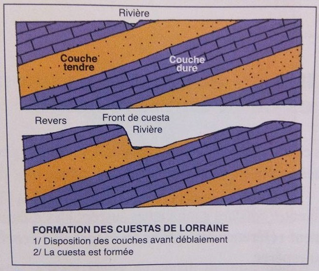
Après le retrait définitif de la mer, les rivières ( ici Attert) ont poursuivi le travail d’érosion en entament les couches les plus tendres les marnes et le sable pour obtenir le relief typique de la Lorraine : les cuestas.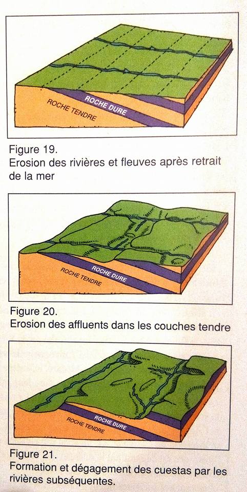
Une cuesta se compose d’une pente faible appelée « revers » qui correspond généralement au dos de la couche résistante.
La pente la plus forte, que l’on nomme le « front », suit la tranche du banc dur qui protège de l’érosion des couches tendres.
Du nord au sud de la Lorraine belge et la Gaume, la cuesta sinémurienne court d’Arlon à Florenville.
La cuesta charmouthienne est bien visible du Bois de Bampont près de Virton jusque Musson et au-delà.
La troisième cuesta dite bajocienne est la plus visible car c’est la plus haute et elle court le long de la frontière française
Pour pouvoir valider cette earthcache :
Vous devrez répondre correctement aux questions suivantes.
Merci d’envoyer vos réponses via mon profil ou via la messagerie geocaching.com, ne les donnez pas dans votre log.
Vous pouvez ensuite loguer la cache "found it", je vous contacterai en cas de problème.
Au WP1 :
1/ Selon le panneau, quelles sont les trois étapes de la formation de la cuesta ?
2/ Citez le nom du fossile présent dans la boîte du panneau ?
Au WP2 :
3/ Quels sont les points cardinaux de l’orientation de la cuesta ?

But what is a cuesta?
A cuesta is a hill, one of the slopes was made steep erosion of alternating soft rock.
The change in sea level along the several marine transgressions and regressions created a superposition of inclined layers of sediment sometimes nature as clay marl or shale, sometimes sand.
After the final withdrawal of the sea, rivers (here Attert) continued the work of erosion begin the softer layers of marl and sand to get the typical relief of the Lorraine: the Cuestas.
A cuesta consists of a low slope called "setback" which generally corresponds to the back of the resistance layer.
The steepest slope, which is called the "front", following the edge of the hard bench that protects the erosion of soft layers.
From north to south of the Belgian Lorraine and the Gaume, the Arlon Sinemurian cuesta short in Florenville.
The cuesta charmouthienne is visible from the Bois de Bampont near Virton Musson and even beyond.
The third cuesta called bajocienne is the most visible because it is the highest and it runs along the French border.
To validate this earthcache:
You will need to correctly answer the following questions.
Thank you send your answers via my profile or via geocaching.com mail, do not give in your log.
You can then log the cache "found it", I will contact you in case of problems.
In WP1:
1 / According to the panel, what are the three stages of the formation of the cuesta?
2 / What are the name of this fossil in the panel box?
In WP2:
3 / What are the cardinal points of the orientation of the cuesta?