You're invited to take a journey through the Maryland's Heart of the Civil War.
The Heart of the Civil War Heritage Area (HCWHA) is an area rich in history, covering portions of Carroll, Frederick and Washington Counties. It is located just below the Mason-Dixon Line, generally viewed as the dividing line between North and South, and above the Potomac River. With one foot in the north, and one foot in the south, the story of the Civil War can be told nowhere better than in this part of Maryland.
No state experienced the Civil War quite like Maryland. Residents of this border state contributed significant resources to both sides of the war effort. Although large portions of the state’s economy relied upon slavery, Maryland lawmakers did not vote to secede from the Union at the outset of the war—though many did not have the opportunity to vote, as they were detained by the federal government because of suspected Confederate sympathies.
Between 1861 and 1865, the Civil War impacted nearly every Maryland resident. Some families faced financial ruin after troops ravaged their land. Thousands of fathers, sons and brothers became casualties of war. For enslaved Marylanders, the conflict ultimately brought about freedom as the new state constitution of November 1864 abolished the practice.
Marylanders witnessed three major military movements during the Civil War: the Maryland (also known as Antietam) Campaign in the fall of 1862, the Gettysburg Campaign in the summer of 1863, and the march to Washington led by Jubal Early in the summer of 1864. Geocachers can visit significant sites from each of these three operations on the Heart of the Civil War GeoTrail.
The mission of the Heart of the Civil War Heritage Area is to promote the stewardship of our historic, cultural, and natural Civil War resources; encourage superior visitor experiences; and stimulate tourism, economic prosperity, and educational development, thereby improving the quality of life in our community for the benefit of both residents and visitors.
The Heart of the Civil War Heritage Area Geotrail launched October 1st, 2016 with 15 geocaches within Maryland's Carroll, Frederick, and Washington Counties. A trackable geocoin will be awarded to the first 200 geocachers, (while supplies last), who find the locations of at least 13 HCWHA caches. To be eligible for the coin, geocachers must download a passport from the Heart of the Civil War website, and record the code word from at least 13 HCWHA geocaches. Geocachers may have their passports validated in person at the Newcomer House at Antietam National Battlefield or at the Visitor Centers in Westminster, Frederick, or Hagerstown. Please refer to the passport for Visitor Center hours and complete validation instructions.
Please note following change. A free prize will still be given to a geocacher who goes to at least 13 HCWHA geocaches and records the code in each of the geocaches on their passport. In addition, geocachers may purchase a trackable Geocoin for $10 at one of the following locations: Frederick Visitor Center, Hagerstown-Washington County Visitor Welcome Center, or Antietam Museum Store. Each of these locations will verify passports by mail and send a coin for a modest handling fee. Call for more information.
Participating in the HCWHA geotrail is fun and we hope that many people join in. However, it is not a requirement for logging your find on this cache once you find the container.
Point of Rocks, a town built along the northern shores of the Potomac River, thrived during its heyday between the 1830s and 1930s. Although today it is a quiet village, the town was at the crossroads of conflict during the Civil War.
This gap between the Potomac River and Catoctin Mountain has attracted commerce for hundreds of years. American Indians once traveled through this region. In the early 1830s, the site was the focus of a fierce legal battle between two transportation giants seeking a route west: the Chesapeake & Ohio Canal Company and the Baltimore & Ohio Railroad. After a four-year dispute in court, the canal was built along the river while the railroad had to be carved out of a hillside above the canal. Both companies hired a large percentage of Irish workers, and thus a Catholic church was central to life in 19th century Point of Rocks.
The river and towpath became targets during the Civil War, with troops from both sides crossing the river between Confederate Virginia and the border state of Maryland here. Confederate Colonel Thomas “Stonewall” Jackson (though his nickname came later) captured 56 locomotives and 300 railcars by stopping traffic east of this point in 1861. In June of 1863—during the weeks leading up to the Battle of Gettysburg—Confederate cavalrymen crossed the river, attacked the nearby Union-held Catoctin Station, captured and then burned a train carrying flour on the way to Harpers Ferry. Thousands of Union troops passed by Point of Rocks later that month en route to Pennsylvania. Confederate Lieutenant Colonel John Mosby attacked the Union garrison at Point of Rocks in the 1864 actions known as the “Calico Raid.”
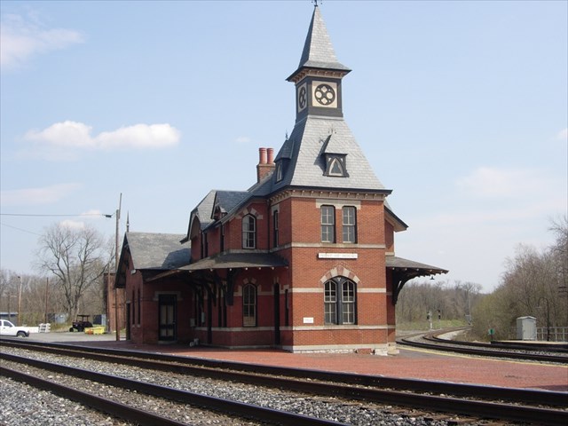
The town’s proximity to the Potomac has left an indelible mark on its identity. Massive floods between 1835 and 1900 wiped out industry and homes in the low-lying parts of town, leaving only a few early structures standing today. Development in the late 19th century—including the 1894 Methodist Church and 1898 Masonic Hall—was limited to the areas of higher ground. Flooding continued into the 20th century, with significant damage sustained in Hurricane Agnes in 1974. One of the town’s main attractions is the picturesque (and still operational) Victorian train station erected by the Baltimore & Ohio Railroad ten years after the end of the Civil War. Another major destination at Point of Rocks is the Chesapeake & Ohio Canal National Historical Park. Visitors can walk, run, or bike along the towpath and even stay overnight in Lockhouse 28, built in 1837, as part of the C&O Canal Trust’s Canal Quarters program. Point of Rocks is the southernmost town in Maryland along the Journey Through Hallowed Ground National Scenic Byway, which runs from Gettysburg to Monticello.
The Geocache
This geocache is an on-site puzzle cache. At the given coordinates, [N39 16.434 W077 32.021], you will find two historical markers. There is parking nearby. Use the sign Point of Rocks During the War to gather information to find the final coordinates to the geocache..
Stage 1
- A = The 1864 raid by Confederate soldiers on the Union garrison here is known by two names. # of letters in the name of the raid listed first on the sign plus 1.
- BC = # of letters in the name of the raid listed second on the sign plus 1.
- DE = # of letters in the former name of Point of Rocks, plus 3.
- F = 2nd digit in number of trail cars captured in May of 1861.
The coordinates for the geocache are N39° 16.ABC, W77° 32.DEF. The checksum of A+B+C+D+E+F is 14. The cache is a clear lock-n-lock container. Parking coordinates have been given for the second stage. The park where the geocache is located is open at 8am.


Thanks to the following members of the Maryland Geocaching Society in placing the hides for this Geotrail: deepdish23, GeoAPPs, lpyankeefan, Phos4s, and ZombieHNTR.