[ITA] ELEMENTO 0
Circa 100 milioni di anni fa, due grandi supercontinenti, Gondwana (comprendente l’attuale Africa) e Laurasia (comprendente l’attuale Europa) separati da un grande oceano detto Tetide, iniziarono a riavvicinarsi tanto che 50 milioni di anni fa circa iniziò la collisione tra Africa ed Europa e lentamente gli strati rocciosi continentali cominciarono a deformarsi e a sovrapporsi iniziando il sollevamento delle Alpi (orogenesi). In particolare l’arco alpino occidentale è formato da grandi pieghe coricate, dette falde di ricoprimento, originate dalle rocce granitiche delle zolle continentali alternate a rocce originate dalla trasformazione di antichi sedimenti oceanici.
Nell’ultimo milione di anni le Alpi sono state interessate da una serie di glaciazioni: sul fondo di questi ghiacciai, tra roccia e ghiaccio, scorrevano turbolenti torrenti subglaciali, la cui capacità erosiva era enorme perché l’acqua era carica di detrito.
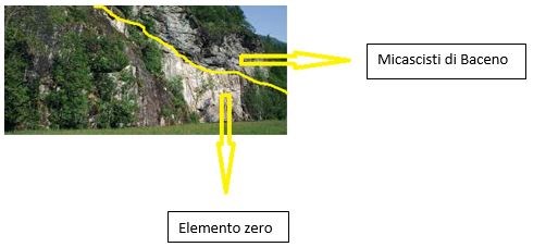
Nella zona che va da Verampio verso Premia, l’imponente azione di modellamento operata dai ghiacciai e dai torrenti del passato, ha inciso a tal punto la roccia da oltrepassare lo strato dei micascisti a granato, mettendo in luce un’altra roccia sottostante, appartenente ad un’unità tettonica più profonda e più antica, lo gneiss granitoide. Lo gneiss che affiora costituisce l’ELEMENTO 0, l’elemento tettonico più profondo dell’intero edificio alpino e che in tutte le Alpi affiora solo nella zona di Verampio.
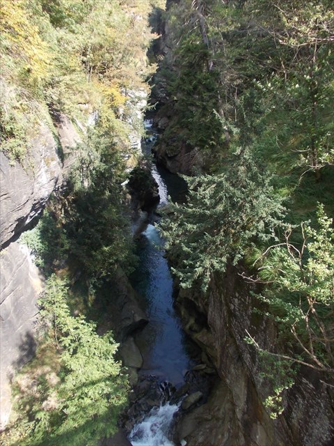
Importanti segni dell’azione erosiva e modellante dell’acqua sono proprio le “Marmitte dei giganti” e gli “Orridi”: alcuni di questi orridi sono percorribili a piedi in quanto non più attraversati dai torrenti, mentre altri sono ancora attivi, cioè percorsi dalle acque, come l’orrido di Arvera e l’orrido di Balmasurda (foto sopra). In particolare dal ponte sopra l’orrido di Balmasurda si ha un punto di osservazione privilegiato per osservare proprio il contatto tra i micascisti di Baceno (le rocce più scure) e l’Elemento 0 (rocce più chiare sottostanti) portato alla luce dall’erosione torrentizia (foto sotto).
Domande:
- Spiegate con parole vostre in cosa consiste l’Elemento 0.
- L’elemento 0 viene citato, nei cartelloni esplicativi, come un punto di osservazione tettonico: con quale nome viene chiamato?
- Nella zona di Verampio, dove affiora l’Elemento 0, lo gneiss che lo forma assume una particolare forma, quale?
- Stimate l’altezza del ponte di Balmasurda dal sottostante orrido.
- Mi farebbe piacere una vostra foto dal ponte dell’orrido di Balmasurda. (FACOLTATIVO)
Per favore inviate le risposte sui messaggi attraverso il nostro profilo; generalmente rispondiamo velocemente dunque attendete la nostra autorizzazione al log.
[ENG] ZERO ELEMENT
Around 100 million years ago two large supercontinents, Gondwana (which included the present-day Africa) and Laurasia (which included the present-day Europe), started to move closer in the vast ocean, Tetide, which separated them. This movement led to a collision between Africa and Europe 50 million years ago from which the continental crust began to deform and overlap its different layers thus setting in motion the raising of the Alps (orogeny). In particular, the western Alpine arc is formed by huge folds resting on one another called covering strata which originated from granite rocks in the continental plates alternated with other rocks which originated from the transformation of ancient marine sediments.
During the last million years the Alps have been affected by a series of glaciations: turbulent subglacial streams flowed between the ice and the rock at the bottom of these glaciers. Their erosive capacity was great since the water carried plenty of rubble.
In the area which goes from Verampio towards Premia the considerable modelling action carried out by these glaciers and streams of the past has carved the rock so much so that they have gone through the garnet micashist layer thus unearthing another underlying rock which belongs to a deeper and more ancient tectonic unit, the granitoid gneiss. The gneiss which surfaces represents the ZERO ELEMENT, the deepest tectonic element of the entire Alpine structure and which only appears in the Verampio area.
Important marks of the erosive and modelling action of the water are precisely “Giant’s Kettles” and gorges: some of these gorges can be walked across since they are not traversed by streams anymore, whereas others are still in activity like the Arvera and Balmasurda (picture above) gorges, where water is still flowing. From the bridge above the Balmasurda gorge there is a particularly privileged observation point to look at exactly the contact between Baceno’s micashists (the darker rocks) and the Zero Element (the paler rocks below) which was brought to light by stream erosion (picture below).
Questions:
- Explain in your own words what is the Zero Element.
- In the explanatory panels, the Zero Element is mentioned as a tectonic observation point: with which name is it called?
- In the Verampio area where the Zero Element surfaces, the gneiss which constitutes it takes a particular shape. Which?
- Estimate the height of Balmasurda’s bridge from the gorge below.
- I would like to see a picture of you from the bridge of Balmasurda’s gorge. (OPTIONAL)
Please send all the answers via the ‘Send message’ option on our profiles; we usually reply quite quickly, so wait for us to give you the green light to log.