Crete was established with the emerging underwater mountain chains. 15 million years ago Crete was part of continental Europe. Western parts of the island are an extension of the Dinaric Alps. Crete is in constant motion. Currently it moves in a southerly direction at a speed of about 1 cm to 25 years. The island is located on the so-called. Plate Aegean, which since its inception pushing for the African plate. Friction causes frequent earthquakes. Movement of the land also takes place vertically, the western part of the island rises, while the eastern immersed into. These differences are already counted in meters and ancient ports in the west today lie on the rocks (eg. Port Falasarnie), and ports in the east on the seabed (eg. Olus).
It is worth mentioning also that the mole is haunted by the earthquake, resulting from tectonic movements. This is a very dangerous phenomenon.
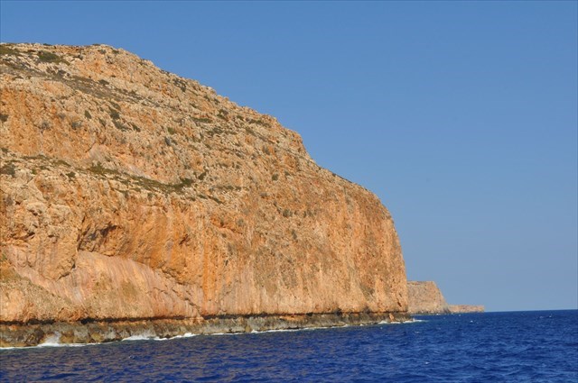
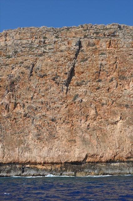
Epicenters of earthquakes, lying near Crete in 66 years Ad "tertio decimo anno Neronis imperii" and 356 AD as "Flavius Valentinianus" reached rock masses at high altitude. Today we can observe during the journey along the peninsula Gramvousa. This is where there has been a dramatic rock outcrops. (Counting scale for centuries)
Earthquakes caused by the movement of the African lithospheric plate, cause a sudden increase in the western part of Crete 6-9 m above sea level. By boat, ship or sailboat we see the distinctive black mark. This place is a phenomenon. There are few places in the world. Even a layman watching this geological phenomenon, he begins to wonder what forces great powers to trigger the movement of tectonic plates. Is Crete connect to africa? That I did not see. Follow the shoreline to watch the geological phenomenon. (Raising the soil on the western Crete thousands of years ago because of the earthquake).The phenomenon of the pressure plate continues. Except that now progressing much slower pace. Subduction is a geological process that takes place at convergent boundaries of tectonic plates where one plate moves under another and is forced down into the mantle. Regions where this process occurs are known as subduction zones The Aegean Sea Plate (also called the Hellenic Plate or Aegean Plate) is a small tectonic plate located in the eastern Mediterranean Sea under southern Greece and far western Turkey. Its southern edge is a subduction zone south of Crete, where the African Plate is being swept under the Aegean Sea Plate.
Aegean plate (ang. Aegean Sea Plate) - a small tectonic plate (microplates), located in the eastern part of the Mediterranean. This includes the peninsula Peloponnese, the Aegean Sea, Crete and the east coast of Turkey. Located between the Eurasian plate to the north, the Anatolian plate in the North East and the African plate in the south and south-west.
According to most authors, it is part of the Eurasian plate. The African Plate is a major tectonic plate straddling the equator as well as the prime meridian. It includes much of the continent of Africa, as well as oceanic crust Which lies between the continent and various surrounding ocean ridges.
Observation of the area coordinates
The location EarthCache we see large forces of nature, napping on Earth. The pressure of tectonic plates on each other causes the voltage that is liberating cause tectonic shocks and influence changes in the environment.
On the eastern side is a peninsula Gramvousa. Here we can observe active seismic zone. Aktive faults is Clearly marked. It runs on the western side of the peninsula. Its shape resembles the letter "Y". Extends the length (S-N) over 11 km along the slopes of the hill until the cape Vouxa. Then the zone of seismic activity descends to the seabed.
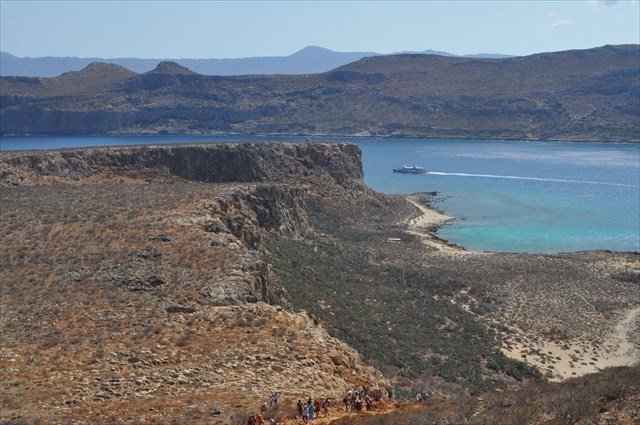
To the north of the location EarthCache is the island Imeri Gramvousa. Here we can see the inactive faults zone. Carefully looking at the island will separate until 4 lines parallel to each other inactive faults with a length of 300 to 950 meters. They extend from the NW - SE. Between 2 and 3 inactive faults line is clearly marked 5 fault. It runs perpendicular to the previous faults, or west to east. A step that extends over the length of 400 m and a height of about 30 m. The wall of the step, visible cracks are vertical, horizontal and transverse. Exterior wall that provides high force movement of the substrate..

To the south of the observation EarthCache lies Gramvousa Balos. A careful observer will see that, from Cape Tigani lying on Gramvousa Balos go 2 lines inactive faults in the N - S and NW - SE.
An active fault is a fault that is likely to become the source of another earthquake sometime in the future. Geologists commonly consider faults to be active if there has been movement observed or evidence of seismic activity during the last 10,000 years.Active faults tend to occur in the vicinity of tectonic plate boundaries. Active faults tend to occur less within the area of any given plate.
Inaktive fault its activity terminated several humdert thousenda years ago. It poses no real threat today.
The appearance and location of active and inactive faults are also related to the construction of the geological north - western Crete. There are there mainly metamorphic limestone Eocene (Tertiary Triassic). In some places they were imposed limestone sediments from the Quaternary period of the Pleistocene. It is the combination of these two different limestone we see faults.
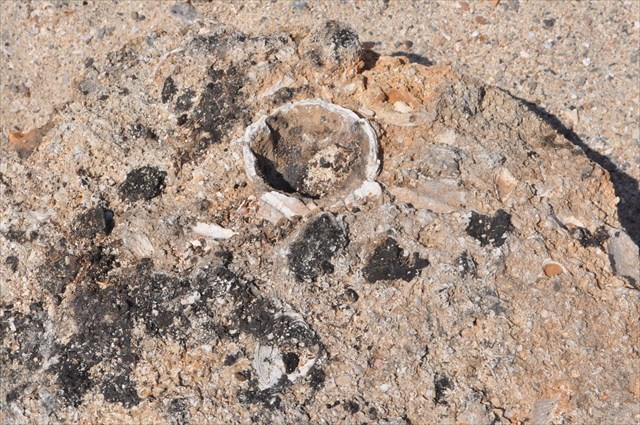
This limestone rocks quaternary are built on a cape Vouxa. Clearly marked lines are 7 layers of sediment of up to 3 m. These same deposits dominate the area Balos. The proof can be well preserved shells of mussels in the rocks occurring in the area, and found at a height of about 7 meters above sea level. While on the island Imeri Gramvousa rocks tertiary and quaternary alternate level according to the inactive faults.
Did you know that?
Crete is imbalanced east – west, rising every year in the west and sinking every year in the east.
Crete is travelling towards Africa with a speed of 8cm yearly.
The Eurasian tectonic plate meets the African one right under Crete.
Questions.
1 / When traveling by boat, sailing around the peninsula Gramvousa Cape Vouxa see visible layers of sediment from the rubble. Determine the angle of ascent of these layers?
2 / Only geo-seekers sailing ship from the point of EC see both lines of errors in the marked points.,
Point A: Here we see a line fault on the peninsula Gramvousa. It tendon over the whole length of the peninsula. Is this the fault is active or inactive?
Point B: Here we see a larger number of line faults. How many do you see? (Which letter of the alphabet make up these lines? ) what are these faults: active or inactive fault?
3 / Optional voluntary: Nice to be seen accompanied by a photograph of geological phenomenon or a ticket for a cruise ship.
Using Wikipedia: Internet.
If you visited my EarthCache, I prepared a special souvenir that you can paste into your profile:
Jeśli odwiedziłeś mojego EarthCache to przygotowałem specjalnie pamiatkę, którą możesz wkleić do swojego profilu:
Code to paste , Kod do wklejenia:
<p align="center"><a href="https://coord.info/GC77JFT" target="_blank"><img src="https://s3.amazonaws.com/gs-geo-images/56a143d5-75ad-4f13-aee4-d22c9e40a193_l.png" title="EarthCache by niuton" width="350" height="222" alt name="ktn" /></a></p>
