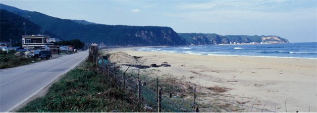
정동진 해안단구는 강원도 강릉시 강동면 정동진리의 안인해수욕장에서 옥계면 금진리의 옥계해수욕장 사이에 있는 해안단구이다. 단구의 길이는 약 4㎞, 너비는 약 1㎞이며, 높이는 해발고도 75~85m이다. 단구의 표면은 거의 수평에 가까운 반면, 절벽인 단구애(段丘崖)는 수직의 바위로 이루어져 있다. 단구의 성분은 적갈색 흙과 모래·자갈이며, 작은 계곡이 발달해 있다.정동진의 해안단구는 한반도 지반의 융기와 해수면 변동의 산물이라고 할 수 있다.
해안단구 위에 자갈층을 자세히 들여다 보면 해안에서 볼 수 있는 납작한 모양의 자갈들인데, 이것은 해식(海蝕)의 흔적으로 과거 이 일대가 바다였음을 보여주는 증거라고 할 수 있다. 즉, 해안 근처의 파식대(波蝕臺)였던 이곳에 파도의 침식으로 마모된 둥근 자갈들이 쌓인 후 지반이 현재의 높이까지 융기하여 단구 지형이 만들어 진 것이다. 또한 정동진의 해안단구면은 5개의 단구면이 나타나는데 이는 적어도 다섯 차례 이상 간빙기를 겪었다고 볼 수 있다. 즉, 신생대 제3기 말에서 제4기 초인 200만~250만 년 전 지반의 융기작용과 해수면 변동에 따라 해수면이 80m 정도 후퇴하면서 바다 밑에 퇴적되어 있던 해저지형이 지금과 같은 위치로 육지화 된 것이다.
You can observe Jeongdongjin Coastal terrace at the cache zone. The coastal terrace is 4 km long, 1 km wide and 75~85 meters above the sea. The surface of the terrace is almost flat but the coastal terrace cliff is formed with vertical rocks. You can observe a lot of flat gravels on the terrace. This is the evidence of coastal erosion and prove that these area was the sea in the past. There are 5 levels of coastal terrace. This means there were at least 5 times of intergracial period.
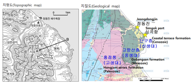
단구의 기반암은 중생대 고방산층이며 그 위에 신생대 제4기 단구층이 퇴적되어 있다. 흥미롭게도 내륙에서 바닷쪽으로 갈수록 현재와 가까운 지질시대를 보여준다. 홍점층은 해성층으로서 평안누층군(평안계) 최하부층이다. 정동진 해안단구 배후지역에 분포한다.
정동진 해안단구의 골격을 이루는 층은 중생대 트라이아스기의 고방산층이다. 고방산층은 담색의 조립질 사암을 중심으로 그 사이사이에 셰일이 끼어있다.
고방산층의 중심이 되는 사암은 침식에 강한 것이 특징인데 정동진 해안단구 해안의 절벽지대는 이러한 지질 특성때문이다. 제4기 단구층은 고방산층 위에 넓게 분포한다.
The basement rock of the terrace is Mesozoic Gobangsan formation, above which Cenozoic coastal terrace formation is sedimented. Interestingly the geographical age become close to the present toward the sea. Hongjom series formation is the marine formation and lowermost. Mesozoic Gobangsan formation is composed of light colored sand stones and shales in the intervals. Sand stones in Gobangsan formation are very strong against erosion and that is why the cliff area of the coastal terrace was formed.
해안단구의 형성
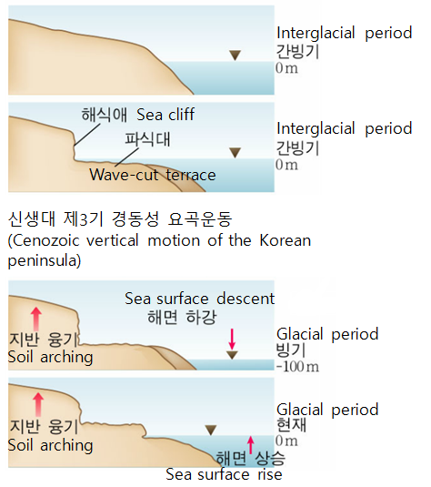 해안에 접한 배후산지의 말단부가 해수면 상승으로 점차 물에 잠긴다.
- 해수면 상승으로 바다에 잠긴 해안 저지대(파식대)가 오랫동안 파랑에 침식되어 평탄한 지형이 된다.
- 이후 신생대 제3기 경동성 요곡운동(1)에 의한 지반 융기로 바다가 물러나면서 평탄해진 구 파식대지형이 육지로 솟아올라 해안단구가 된다.
(1)동해안 지역의 융기-서해안 지역의 침강 패턴의 조륙운동
Formation of coastal terrace
- Ends of the mountain area bordering the coast are descending into the sea as the sea water level rises.
- Seaside lowland descended under the water as a result of sea water level rising are being eroded and flattened with sea waves.
- Soil arching with Cenozoic vertical motion of the Korean peninsula(2) makes water-cut terrace rise and it becomes coastal terrace.
(2)an epeirogenic movement of uplift in the east side-subsidence in the west side of the peninsula
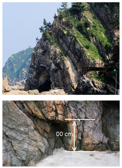
왼쪽 위의 그림은 정동진 해안단구 절벽에 발달한 해식동이고 그 아래 그림은 해식동안에 있는 작은 해식동이다. 동굴 윗쪽 지층이 고방산층이다. 두꺼운 퇴적층이 지각변동으로 활처럼 휘어졌다. 정동진 포구에 있는 부채바위 그리고 심곡항 포구 남단 도로변에 있는 사다리바위도 같은 고방산층이다.
The upperleft picture is a sea cave formed on the cliff of coastal terrace and lowerleft one is a small sea cave in a big sea cave. Above the cave is the Gobangsan formation. A thick sediment formation was bended like a bow as a result of the diastrophism. You can observe the other examples of Gobangsan formation such as Fan shaped rock At Jeongdong port and Ladder shaped rock at Simgok port.
[로그하는 방법]
- 정동진의 해안단구면 위의 지형은 왜 평탄한가?
- 정동진의 해안단구의 절벽면이 수직을 이루는 이유는 무엇이라고 생각하는가?
- Waypoint에는 위 사진속의 해식동굴이 있다. 이 동굴을 이루고 있는 지층은 무엇인가?
- 해식동안에 있는 사진속의 작은 해식동의 높이는 대략 얼마인가?
- Cache zone에서 해안단구를 배경으로 당신 또는 당신의 GPS를 찍은 사진을 로그에 올려주세요. (선택사항이지만 사진을 올려주시기를 부탁드립니다.)
- 답을 제 Profile에 있는 메시지창을 이용해 제게 보내주세요. 이제 로그하셔도 됩니다. 답에 문제가 있을 경우 제가 메시지를 드리겠습니다.
[How to log]
- Why is the area above the Jeongdongjin coastal terrace flat?
- Why do you think the cliff on the Jeongdongjin coastal terrace is vertical?
- There is a sea cave in the above picture at Waypoint. What formation is composing this sea cave?
- How high is the entrance of a small cave in a big one that you see in the picture above?
- Upload the photo of you or your GPS with the Jeongdongjin coastal terrace at the cache zone in the background! (The task is optional but I would highly appreciate if you would do so.)
- Please send the answers to me by message on my profile! Now you may log as 'Found'. If the answer is not correct, I will contact you.
(Reference)
http://geoj.tistory.com/95
http://blog.naver.com/kwontor55/50175011274
http://study.zum.com/book/13230
| I have earned GSA's highest level: |
 |