La promenade
Le site a été aménagé afin de permettre à tous d'y accéder. Il n'est cependant pas accessible aux poussettes, et le port de bonnes chaussures est recommandé.
Comptez 2 heures de visite minimum, et plutôt plus si comme nous vous prenez le temps d'observer avec attention tout ce qui en fait un endroit hors du commun :
- sa flore : les conditions de température et d'humidité font de cet endroit un site propice au développement de plantes luxuriantes.
- sa faune : des espèces peux communes peuvent êtres observées ici : vautours fauves et, si vous avez de la chance, gypaètes barbus...
- sa structure géologique bien évidement. Le sujet qui nous intéresse pour cette Earthcache.
L'accès au site est payant. En 2016, le ticket d'entrée était de 5 euros par adulte et 4 euros par enfant.
Il n'est ouvert que du 15 mars au 15 novembre, de 8 heures à la tombée de la nuit, en journée continue.
Pendant la période estivale, entre mi-juillet et mi-août, privilégiez une visite de bon matin ou en fin de journée afin d'éviter les fortes affluences. Ce site est parfois victime de son succès.
Un peu de géologie...
Il y a environ 12000 ans, les eaux issues de la fonte des névés piégées dans un petit cirque glacière situé en amont du site ont façonné une vallée, par l'érosion de terrains superficiels tendres datant du crétacé supérieur.
Environ 6000 ans plus tard, ces eaux chargées d'acide carbonique ont atteint et dissout les roches calcaires dures sous-jacentes. Ces roches étaient déjà fracturées et karstifiées, facilitant l'infiltration de l'eau.
Il en est progressivement résulté une gorge.
Ce processus a perduré jusqu'à atteindre des roches de l'aire primaire (grès et schistes) datant de l'ère carbonifère, soit d'il y a environ 320 millions d'années.
Le canyon de la Kakuetta est donc le résultat de l'action conjointe du ruissellement des eaux de surface et de l'infiltration dans un sol calcaire des eaux souterraines.
Aujourd'hui, l'entaille dans la barre calcaire atteint jusqu'à 300 mètres de haut par endroits.
Le torrent qui coule au fond du canyon est toujours alimenté par l'eau provenant à la fois du ruissellement, et par l'apport d'un réseau de rivières souterraines résultant de l'infiltration de l'eau dans le sol karstique du plateau de la Pierre Saint-Martin.
Du fait de l'abondance et de la diversité de son alimentation en eau, le niveau de la Kakuetta peut, en cas de fortes précipitations, monter de plusieurs mètres en quelques minutes, comme ce fut le cas en 1992.
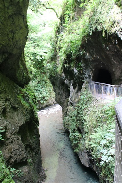
On peut en s'y promenant retrouver des traces de l'histoire géologique et de la genèse de ce site.
L'une d'entre elle se trouve au bout du chemin, dans une grotte creusée par l'érosion dans le calcaire. Ne manquez pas de la visiter, même si par jour de forte affluence, son accès en parfois assez laborieux !
Un panneau d'information situé aux coordonnées de la cache complétera ce descriptif. Il est agrémenté de schémas très clairs imageant le processus décrit ci-dessus.
La Earthcache
Comme pour toutes les Earthcaches, il n'y a aucune boite à trouver.
Loguez cette cache "Found it" et envoyez-moi vos propositions de réponses aux questions qui suivent soit via mon profil, soit via la messagerie geocaching.com (Message Center), et je vous contacterai en cas de problème.
Les questions :
1) 6000 ans après avoir creusé une vallée par érosion, l'eau a continué son oeuvre pour former un canyon. Décrivez ce second processus.
2) Si la grotte permet d'observer la nature calcaire des parois de la gorge, un autre site très spectaculaire est le témoin de l'infiltration de l'eau dans le sol et de la présence d'un réseau de rivières souterraines.
Quel est ce site ? En quoi est-il un témoin de l’existence du réseau sous-terrain ?
3) Il y a 12000 ans, la fonte de névés piégées dans un petit cirque a creusé une vallée par érosion. Quel est le nom de ce cirque ?
Vous trouverez cette information en consultant le panneau d'information situé aux coordonnées de la cache.
Nous vous souhaitons une agréable promenade, et espérons-le, des souvenirs inoubliables.
English
The Kakuetta gorges is one of the greatest places to visit in the Basque back country.
The walk
You will need to do a 4 km (about 2 hours, maybe more if you are curious) return walk. It is easy, but not accessible to accessible to strolers, and wearing good shoes is recomended.
There is a fee to access the site : 5 euros per adult and 4 per child.
It is only openned from March 15th to November 15th, from 8:00 AM to the twilight.
During the summer vacation period (mid-July to mid-August), prefer the early morning or the end of the day to do this walk, to avoid the crowd that can sometimes be met here.
Let's talk about Geology...
About 12 000 years ago, waters coming from the melting snow captured in a small circus located upstream shaped a valley by eroding the soft topsoil.
About 6 000 later, these waters, loaded of carbonic acid, reached and dissolved the underlying limestone. These rocks were already fissured and karstified, making the water infiltration easier. This gradualy digged a gorge.
This process continued its work until the underlying layer, composed of older rocks (sandstone and shale) dated from the Carboniferous period (around -320 millions years ago).
The Kakuetta gorge is the result of the combined action of the runoff and the infiltration of waters into the limestone, joining a huge underground water network.
Today, the notch in the limestone wall is reaching 300 meters high at some places.
The torrent flowing in the canyon is still fed by waters both coming from the runoff and by underground waters coming from the karstic soil of the La Pierre Saint-Martin's plateau.
Due to the abundance and diversity of water sources, the Kakuetta level can sundenly and dramatically rise in case of high precipitation (several meters in few minutes, as it happened in 1992).
During your walk, you still can find many traces of the geological history and the birth of the Gorge. One of them is located at the end of the path, in a cave digged in the eroded limestone. Do not miss it, even if it might by crowdy sometimes.
An information board, located at the cache coordinates will bring you additional informations, including schemas clearly showing the processes described above.
The Earthcache
As for all Earthcaches, there is no box to be found.
Log a "Found it" and please send me your answers to the following questions either via my profile, either via the geocaching.com Message Center, and I will come back to you in case of problem.
The questions :
1) 6 000 years after digging a valley, the water continued its work to shape a un canyon. Please discribe this second process.
2) If in the cave you can observe the limestone that is mainly composing the gorge wall, another spectacular site bears witness of the water infiltration in the soil and the presence of a significant underground water network. What is this site ? In what sense is it bearing witness of the existance of the underground water network ?
3) 12 000 years ago, the melting snow captured in a small circus located upstream shaped a valley. What is the name of this cirque ?
You can find this information by reading the information board at the cache coordinates. It is french only, but the word "cirque" is used in both language, so it should be easy to find.
We wish you a nice walk that will hopefully will leave you lasting memories.