[ITALIANO]
Geodesia, punto geodetico
Un punto geodetico è un punto fissato stabilmente nel terreno o in un edificio, tipicamente in rame, ottone o alluminio. I misuratori ufficiali sono tarati per garantire la precisione al centimetro.
Qui puoi verificare l'accuratezza del tuo dispositivo GPS: posiziona il tuo dispositivo sul punto geodetico e rileva l'accuratezza. Ti sarei grato se volessi lasciare nota nel log del modello del tuo dispositivo GPS e della deviazione rilevata!
[ENGLISH]
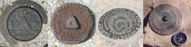
Geodesy, survey point
A survey point is a stable point, usually in the ground or in a building, normally made of copper, brass or aluminium. The professional surveyors are accurate to the centimetre.
Here you can check the accuracy of your GPS device: just place you device on the survey point, and take note of its accuracy. I would be grateful if you could note down, in the log, your device's model and the deviation!
[DEUTSCH]
Geodäsie, Vermessungspunkt
Ein Vermessungspunkt ist ein im Boden oder an einem Gebäude stabil markierter Punkt meist aus Kupfer, Messing oder Aluminium. Er dient Geodäten zur Vermessung und ist amtlich zentimetergenau ermittelt.
Hier kannst du die Genauigkeit deines GPS-Geräts überprüfen. Lege das GPS-Gerät auf den Vermessungspunkt und lass dir die Genauigkeit anzeigen. Ich würde mich freuen, wenn du Modell und Abweichung deines GPS-Gerätes ins „Log“ schreiben würdest!
 Link:
Link:
Catalogo dei punti geodetici