You're invited to take a journey through the Maryland's Heart of the Civil War.
The Heart of the Civil War Heritage Area (HCWHA) is an area rich in history, covering portions of Carroll, Frederick and Washington Counties. It is located just below the Mason-Dixon Line, generally viewed as the dividing line between North and South, and above the Potomac River. With one foot in the north, and one foot in the south, the story of the Civil War can be told nowhere better than in this part of Maryland.
No state experienced the Civil War quite like Maryland. Residents of this border state contributed significant resources to both sides of the war effort. Although large portions of the state’s economy relied upon slavery, Maryland lawmakers did not vote to secede from the Union at the outset of the war—though many did not have the opportunity to vote, as they were detained by the federal government because of suspected Confederate sympathies.
Between 1861 and 1865, the Civil War impacted nearly every Maryland resident. Some families faced financial ruin after troops ravaged their land. Thousands of fathers, sons and brothers became casualties of war. For enslaved Marylanders, the conflict ultimately brought about freedom as the new state constitution of November 1864 abolished the practice.
Marylanders witnessed three major military movements during the Civil War: the Maryland (also known as Antietam) Campaign in the fall of 1862, the Gettysburg Campaign in the summer of 1863, and the march to Washington led by Jubal Early in the summer of 1864. Geocachers can visit significant sites from each of these three operations on the Heart of the Civil War GeoTrail.
The mission of the Heart of the Civil War Heritage Area is to promote the stewardship of our historic, cultural, and natural Civil War resources; encourage superior visitor experiences; and stimulate tourism, economic prosperity, and educational development, thereby improving the quality of life in our community for the benefit of both residents and visitors.
The Heart of the Civil War Heritage Area Geotrail launched October 1st, 2016 with 15 geocaches within Maryland's Carroll, Frederick, and Washington Counties. A trackable geocoin will be awarded to the first 200 geocachers, (while supplies last), who find the locations of at least 13 HCWHA caches. To be eligible for the coin, geocachers must download a passport from the Heart of the Civil War website, and record the code word from at least 13 HCWHA geocaches. Geocachers may have their passports validated in person at the Newcomer House at Antietam National Battlefield or at the Visitor Centers in Westminster, Frederick, or Hagerstown. Please refer to the passport for Visitor Center hours and complete validation instructions.
Please note following change. A free prize will still be given to a geocacher who goes to at least 13 HCWHA geocaches and records the code in each of the geocaches on their passport. In addition, geocachers may purchase a trackable Geocoin for $10 at one of the following locations: Frederick Visitor Center, Hagerstown-Washington County Visitor Welcome Center, or Antietam Museum Store. Each of these locations will verify passports by mail and send a coin for a modest handling fee. Call for more information.
Participating in the HCWHA geotrail is fun and we hope that many people join in. However, it is not a requirement for logging your find on this cache once you find the container.
Brothers George and William Boone founded the town now known as Boonsboro in 1792 along the wagon road between Frederick and Hagerstown. The town—which has also been known as Boones Berry, Margaretsville, Boonesborough—grew slowly, with only 24 houses by 1803. A watershed moment in the town’s history took place in 1827, when Boonsboro citizens built the nation’s first monument honoring George Washington atop nearby South Mountain. The 34’ tall rugged stone tower underwent significant repairs by the Civilian Conservation Corps in 1936 and welcomes visitors today as part of South Mountain State Battlefield.
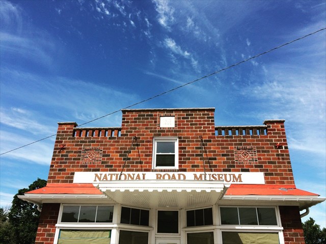
Boonsboro’s history is closely tied to its location along the National Road. The first major improved highway built by the federal government, the National Road connected the Eastern and mid-Western portions of the U.S. by serving as a link between the Potomac and Ohio Rivers. Construction began in 1811 to connect Cumberland, Maryland to Wheeling, Virginia (now West Virginia). To complement this national infrastructure initiative, Maryland’s General Assembly created the Baltimore National Pike (also known as the Bank Road) connecting Baltimore with Cumberland. The stretch of the turnpike from Boonsboro to Hagerstown was the first road to be paved with macadam (named after the Scottish engineer who pioneered the technique, John Loudon McAdam) in 1823. Thousands of migrants took the National Road west to seek better economic opportunities. The National Road served as a major route for moving supplies and troops during the Civil War, including sending men wounded at the battles of South Mountain and Antietam to makeshift hospitals in local churches and public buildings.
Today, the Historic National Road includes portions of Route 40, Alternate Route 40, and Maryland Route 144. Learn more about the National Road on the Maryland National Road Association website or stay tuned for detailed on the opening of the new National Road Museum. Soak up local history at the Boonsborough Museum of History or the Trolley Station Museum.
The Geocache
This geocache is an on-site puzzle cache. At the given coordinates, [N39 30.587 W077 39.243], you will find Civil War Historical Markers. From these markers subtract .156 to the North Coordinates final three digits, and add .121 to the West Coordinates final three digits. The geocache is a clear lock-n-lock container.


Thanks to the following members of the Maryland Geocaching Society in placing the hides for this Geotrail: deepdish23, GeoAPPs, lpyankeefan, Phos4s, and ZombieHNTR.