Les coordonnées de la earthcache ne sont pas celle du panneau d'informations, pour trouver celui-ci utiliser le WP1 / The coordinates of the earthcache not that of the information panel to find it using the WP1
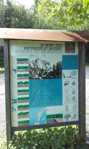
Le site de la brèche au diable et du Mont Joly témoigne d’événements géologiques ayant modelé une grande part des paysages bas-normands. Les couches de grès redressées qui affleurent appartiennent au flanc sud du pli synclinal d’Urville / Soumont-saint-Quentin constituant le tréfonds de la région. A l’écart de la vallée du Laizon, des assises calcaires forment le soubassement tabulaire de la plaine.
La coupe géologique schématique résume la diversité des formations et leurs discordances. En l’état actuel des connaissances, la géologie du site résulte de l’histoire régionale suivante:
Au Briovérien des boues marines donnent naissance à des schistes et des grès. A la suite de l’orogénèse cadomienne, émergent de puissants reliefs qui seront largement aplanis par l’érosion.
Au cambrien la mer envahit le continent mais les hauteurs résiduelles la scindent en trois bassins avec au centre celui concernant le site du Mont Joly. L’émersion des terrains à la fin du Cambrien conduit à la formation des schistes et grès rouges dans les secteurs de May-sur-Orne, d’Urville et de Saint-Rémy.
A l’Ordovicien les sédimentations marines reprennent. Au cours d’une phase climatique chaude et humide, sur le continent, le fer des roches est dissout et entrainé vers la mer. Précipitant dans les hauts fonds, il s’agglomère autour des grains de sable. La cimentation de ces oolithes ferrugineuses forme les minerais de fer de May-sur-Orne, de Soumont-saint-Quentin et de Saint-Rémy-sur-Orne.
Au Silurien des vases marines charbonneuses sont à l’origine des schistes et des calcaires noirs conservés au cœur des racines du pli s’Urville / Soumont-saint-Quentin.
A la fin de l’ère primaire, l’orogénèse hercynienne donne naissance au ........1.......... Elle affecte particulièrement notre région au cours du ........2........... Le synclinal d’Urville / Soumont-saint-Quentin, avec ses couches redressées et faillées en est une illustration locale.
Au Trias une régression marine livre les reliefs à une intense érosion qui aboutit à une vaste pénéplaine dont les dépressions sont comblées par des dépôts continentaux (sables, galets fluviatiles et argiles rouges).
Au jurassique la mer envahit progressivement le plateau en contournant des îlots de roches dures qui pointent au large d’une côte dont le tracé suit une ligne joignant approximativement Carentan à Falaise. C’est dans ces fonds que se forment les calcaires de la plaine de Caen.
Au Tertiaire et au Quaternaire, l’érosion des pluies et des rivières déblaie des masses considérables de sédiments qui recouvraient les calcaires jurassiques et dégage les grès primaires du promontoire du Mont Joly. Le Laizon, pour traverser a du profiter d’une zone où la roche était fragilisée, disloquée par un réseau de fractures.
Questions:
Complètez le texte concernat l'ère primaire: 1= 2=
Dans l'échelle géologique se trouvant sur la partie gauche du tableau, donnez moi les deux fomation qui se produisent en -130 Ma (jurassique)
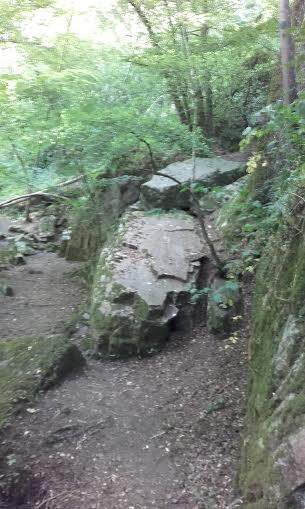
Sur la coupe géologique du Mont-Joly, quel type de roche trouve t'on sous la brèche au diable ?
Pour valider votre réponse, donnez moi les chiffres isncrit à l'arrière du panneau voie sans issue.
Enfin, mais optionnel, vous pouvez joindre une photo de vous au niveau de puit ou du petit pont de la brèche au diable.
Loguez cette cache "Found it" et envoyez-moi vos propositions de réponses soit via mon profil, soit via la messagerie geocaching.com (Message Center), et je vous contacterai en cas de problème.
The site of La brèche au diable and Mont Joly testify of geological events that shaped much of the Lower Normandy landscapes. The layers of sandstone straightened who outcropping belong to the southern flank of the syncline Urville / Soumont-Saint-Quentin constituting the depths of the region. Away from the valley of Laizon, basis limestone form the bedrock of the plains. The schematic geological cup summarizes the diversity of training and uncomformity. In the current state of knowledge, the geology of the site results from the following regional history:
In Brioverian, sea mud give birth to shales and sandstones. Following the orogeny Cadomian, emerge powerful reliefs which will be largely flattened by erosion.
In Cambrian the sea invades the continent but residual heights splits the sea into three basin with in the center that site of Mount Joly. The emersion of land at the end of the Cambrian led to the formation of red sandstone and shale in the sectors of May-sur-Orne, d'Urville and Saint-Rémy.
In Ordovician, marine sedimentation resumed. In a hot and humid climatic phase, on the mainland, iron is dissolved of the rocks and dragged towards the sea. Precipitant in the shoals, it accumulates around sand grains. The Cementing of these ferruginous oolites form ores of iron from May-sur-Orne , Soumont-Saint-Quentin and Saint-Rémy-sur-Orne.
In Silurian, the marines muds carbonaceous are at the source of schists and calcareous black kept in the heart of the crease Urville / Soumont-Saint-Quentin.
At the end of the primary era, the Hercynian orogeny gave birth to the ........1........... It particularly affects our region during the ........2.......... The syncline Urville / Soumont-Saint-Quentin, with his straightened and faulted layers is a local illustration.
In Triassic, a marine regression deliver on the reliefs an intense erosion that leads to a vast peneplain whose depressions are filled by continental deposits (sands, fluvial gravel and clays red).
In Jurassic, sea gradually invades the plateau bypassing islands of hard rocks that link at off a coast whose route follows a line joining approximately Carentan Falaise. It is in these funds that form the limestone of the plain of Caen.
In Tertiary and Quaternary, the erosion of rains and rivers clears huge masses of sediment that covered the Jurassic limestone and discover primary sandstone promontory of Mont Joly. The Laizon can to cross has the advantage of an area where the rock was weakened, disrupted by a fracture network.
Question:
Complete the text on the primary era: 1= 2=
In the geological scale on the left side of the table, give me the two formation that occur -130 Ma (Jurassic)
On the geological cup of Mont Joly, what kind of rock you found it under la brèche du Diable ?
To validate your answer, give me the numbers listed on the back of pannel "voie sans issue".
Last but optional, you can attach a picture of yourself at the small well or on bridge from La brèche du Diable.
You can log this earthcache " Found it " and send me your proposals of answers either via my profile, or via the geocaching.com messaging (Center message), and I shall contact you in case of problem.