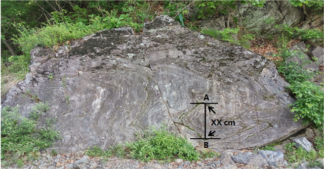
캐시존에는 지층이 종잇장처럼 구겨진 습곡을 간직한 높이 2.5m, 너비 7 m 정도의 바위가 눈길을 끈다. 이 습곡은 지하 10 km에서 무르고 연해진 고생대 퇴적암이 2억~3억년 전 한반도가 대규모 지각변동을 받았을 때 이리 저리 굽어진 것이다.
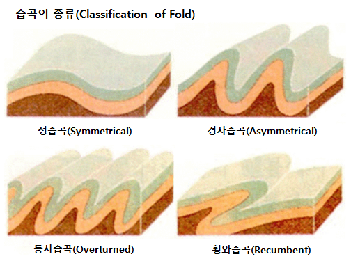
습곡(褶曲)은 지층이 수평으로 퇴적된 후 횡압력을 받아 휜 상태이다. 이러한 구조를 습곡이라 하고 지층이 위를 향해 휜 부분을 배사 구조, 아래를 향해 휜 부분을 향사라 한다. 그리고 배사와 향사 사이의 옆면을 날개라 한다. 습곡의 종류는 정습곡, 경사습곡, 등사습곡 그리고 횡와습곡이 있다.
You can find a big rock[2.5 m(H) x 7 m(W)] wrinkled in aweful shape at the cache zone. It is a good example of the fold. The Paleozoic sedimentary rock was wrinkled badly with a large scale of diastrophism 10 km underground 200~300 million years ago.
 A geological fold occurs when one or a stack of originally flat and planar surfaces, such as sedimentary strata, are bent or curved as a result of permanent deformation. Synsedimentary folds are those due to slumping of sedimentary material before it is lithified. Folds form under varied conditions of stress, hydrostatic pressure, pore pressure, and temperature gradient, as evidenced by their presence in soft sediments, the full spectrum of metamorphic rocks, and even as primary flow structures in some igneous rocks.
아래 사진은 은대리 판상절리 모습이다. Waypoint에 가면 높이가 25 m에 이르는 웅장한 현무암 절벽이 펼쳐져 있다. 기왓장을 쌓아놓은 형태로 현무암 절벽에 금이 가 있다. 형성 원인은 아직 정확히 밝혀지지 않았지만 용암 위 아래의 수축률 차이로 인한 것으로 추정되고 있다. 현무암 절벽 밑부분에 강바닥에서 볼 수 있는 모서리가 둥근 자갈이 층을 이루고 있다. 이 층을 백의리 퇴적층이라고 한다. 백의리층을 이루는 자갈들의 원마정도와 크기, 자갈 등의 퇴적양상 등으로 미루어 볼 때, 이것이 퇴적될 당시의 환경은 하천이었을 것이다.

The above picture is a planticular joint of Eundae-ri(Taken at Waypoint). You will be surprised with a magnificent view of 25 m high cliff of basalt. The basalt cliff is cracked forming planticular joints. The reason of the planticular joint formation was not clearly identified yet but the general theory is that the basalt was cracked with the diffenent contraction ratio between upper and lower lava while being cooled down. At the lower part of the basalt cliff, round gravel formation is observed. This is the Baekui-ri sedimentary formation. Judging from wearing out, appearance of sedimentation and size of the gravels forming the Baekui-ri formation, this area was supposed to be the stream at that time.
[로그하는 방법]
- 백의리 퇴적층은 큰 자갈이 모여 굳어진 바위이다. (진실/오류)
- 은대리 습곡은 어떤 종류의 습곡인가?
- 맨 위의 사진에서 A와 B사이의 거리는 몇 cm입니까?
- 판상절리를 배경으로 당신 또는 당신의 GPS를 찍은 사진을 로그에 올려주세요. (선택사항이지만 사진을 올려주시기를 부탁드립니다.)
- 답을 제 Profile에 있는 메시지창을 이용해 제게 보내주세요. 이제 로그하셔도 됩니다. 답에 문제가 있을 경우 제가 메시지를 드리겠습니다.
[How to log]
- Baekui-ri sedimentary formation is rock comprised of big gravels. (True/False)
- What type is Eundae-ri fold?
- What is the distance between A and B in the uppermost picture?
- Upload the photo of you or your GPS with the planticular joints in the background! (The task is optional but I would highly appreciate if you would do so.)
- Please send the answers to me by message on my profile! You may log as 'Found'. If the answer is not correct, I will contact you.
(Reference)
연천군청
Wikipedia
| I have earned GSA's highest level: |
 |