사취(砂嘴)가 발달한 아름다운 해빈(海濱)
대천해수욕장의 백사장은 언제, 어떻게 형성되었을까? 마지막 빙하기를 거치고 약 1만 년 전부터 서해안의 해수면이 급속하게 상승한다. 바닷물의 높이가 현재 수준에 도달한 것은 약 2,500년 전 즈음이었다. 이 시기를 전후해 서해안의 해안지형작용이 안정적으로 진행되었을 것으로 예측된다. 이 지역의 지형도 등 여러 가지 정황으로 미루어볼 때, 대천등대가 위치한 곶(A 지역)에서 사취가 남동쪽으로 길게 발달하여 남쪽 곶(B 지역)에 연결되었을 가능성이 크다. 현재 남쪽 곶은 해빈이 형성되기 이전에는 시스택이나 암초로 구성된 작은 섬이었을 가능성도 있다.
초기의 사취는 굵은 자갈이나 호박돌 크기로 형성되다가 퇴적이 진행되어 고도가 높아지고 간조 때에 뭍으로 드러나는 시간이 길어지면서 작은 자갈이나 모래가 쌓여 이 섬은 육지와 연결되는 육계도가 되었을 것으로 추측된다. 연결 부위가 바닷물과 바람의 퇴적작용으로 규모가 증가함에 따라 육지 쪽으로는 배후의 간석지를 파랑으로부터 보호하고, 바다를 향해서는 파도가 몰려와 부서지는 아름다운 해빈으로 발달했을 것으로 보인다.
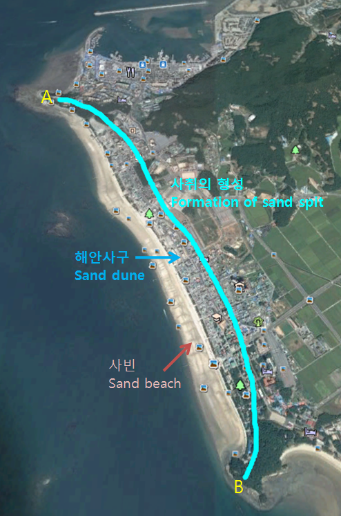
Beautiful beach where a sand spit developed
When and how was the sand beach formed here? The sea level rose very fast about 10,000 years ago after the last glacial period in west coast of Korean peninsula. The sea level reached the current level about 2,500 years ago. And in that time or so topographic action in the west coast seemed to be stabilized. Judging from the topographic map and vavious circumstances, from the cape(POINT A) where the Daecheon lighthouse is located a sand spit seemed to develop to southeasterly direction and be conneted to the southern cape(POINT B). The southern cape seemed to have been a sea stack or a little rock island before the sand beach was formed.
At first a sand spit was comprised of big gravels or boulder. Afterwards as a sea bottom was raised with the sedimentation and exposed above the sea for a longer time during ebb tide, small gravels and sand deposited to connet the island with the shore. The island became a land-tied island. The place conneting the island with the shore was getting bigger with the sedimentation of wind and sea wave. It protected a tideland from the sea wave and developed as a beautiful beach.
사취(砂嘴, Sand Spit)
사취(砂嘴) 또는 모래부리는 파도나 조류, 바람 등에 의해 모래나 자갈이 해안에서 바다로 부리처럼 길게 뻗어나간 둑 모양의 모래톱을 말한다. 사취가 육지와 육지 사이를 연결하여 만(灣)의 입구를 막아 석호(潟湖)로 만든 것을 사주(砂洲)라고 하고, 육지와 섬 사이를 연결한 것을 육계사주(陸繫砂洲)라고 한다. 해안가까이에 있는 해수는 일반적으로 파랑, 조류, 조석에 의해 운반되어온 댜량의 퇴적물을 포함하고 있다. 만의 입구에서 퇴적물은 연안류에 의해 수심이 더 깊은 곳으로 운반되는데 수심이 깊은 곳에서는 유속이 느려져서 퇴적물의 퇴적이 이루어진다. 이러한 퇴적물은 한쪽 끝이 육지와 연결되어 있으며, 해류가 흘러가는 방향인 바다 쪽은 길게 퇴적되어 있는데 이를 사취라고 한다.
A spit or sandspit is a deposition bar or beach landform found off coasts. It develops in places where re-entrance occurs, such as at a cove's headlands, by the process of longshore drift and longshore currents. The drift occurs due to waves meeting the beach at an oblique angle, moving sediment down the beach in a zigzag pattern. This is complemented by longshore currents, which further transport sediment through the water alongside the beach. These currents are caused by the same waves that cause the drift.
사구(砂丘, Dune)
사구(砂丘)는 바람에 의하여 모래가 이동하여 퇴적된 언덕이나 둑 모양의 모래 언덕이다.
A dune is a hill of sand built by either wind or water flow. Dunes occur in different shapes and sizes, formed by interaction with the flow of air or water.
시스택(Sea Stack)
암석으로 이루어진 곶(串)이 파랑의 강한 침식을 받아 깎이는 과정에서 차별적으로 침식이 적게 된 단단한 부분이 파식대 위에 돌출하여 작은 바위섬을 이루게 되는데 이를 시스택이라 한다. 즉 시스택은 해식애가 파랑의 침식을 받아 후퇴할 때 차별 침식을 받아서 암석의 약한 부분은 떨어져 나가고 단단한 부분이 남아 있는 것이다. ‘sea stack’에서 stack은 스코틀랜드 어로 우뚝 선 높은 바위란 뜻이다.
A stack or sea stack is a geological landform consisting of a steep and often vertical column or columns of rock in the sea near a coast, formed by wave erosion. Stacks are formed over time by wind and water, processes of coastal geomorphology.
육계사주(陸繫砂洲, Tombolo)
육계사주(陸繫砂洲)는 육지와 섬, 섬과 다른 섬이나 암초 사이에 모래나 자갈 등이 쌓여 연결된 퇴적 지형으로, 사주(砂洲)의 일종이다. 이 때 육계사주에 의해 육지와 연결된 섬을 육계도(陸繫島)라고 한다.
A tombolo is a deposition landform in which an island is attached to the mainland by a narrow piece of land such as a spit or bar. Once attached, the island is then known as a tied island. Several islands tied together by bars which rise above the water level are called a tombolo cluster.
[로그하는 방법]
- 사빈은 바닷물이 모래를 해안선을 따라 쌓아올려 만들어 놓은 지형으로 조수의 영향을 직접 받는 부분을 말한다. (진실/오류)
- 사빈의 모래는 바닷바람에 의해 내륙쪽으로 이동하여 해안사구를 형성한다.(진실/오류)
- 시스택은 차별침식에 의해 생긴다. (진실/오류)
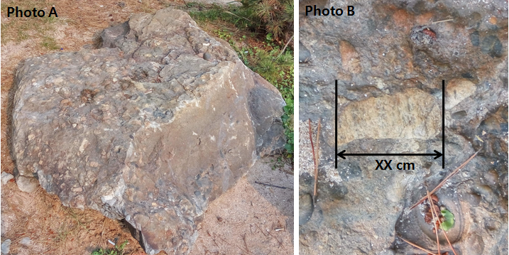
- Waypoint에 가면 이 지역에 분포된 바위 표본을 전시한 작은 암석원이 있다. 다음은 아래 Photo A의 바위를 설명한 것이다. (1) 이 바위는 무슨 종류의 바위인가? (a. 규암, b. 석회암, c. 역암, d. 응회암) "이 암석은 크기가 2mm 이상인 둥근 알갱이가 30% 이상 들어 있는 쇄설성 퇴적암이다. 크기가 2~4mm의 퇴적 알갱이를 그래뉼(Granule), 4~64mm의 퇴적 알갱이를 자갈, 64~256mm의 퇴적 알갱이를 왕자갈, 256mm 이상의 알갱이를 거력(Boulder)이라고 하는데, 이 암석에는 크기가 2mm 이상인 알갱이들이 많이 들어 있는 것이다." (2) 이 바위에는 Photo B에 보이는 작은 돌이 박혀 있습니다. 이돌의 크기는 얼마입니까?
- 캐시존에 설치된 데크와 해수욕장이 함께 보이도록 당신 또는 당신의 GPS를 찍은 사진을 로그에 올려주세요. (선택사항이지만 사진을 올려주시기를 부탁드립니다.)
- 답을 제 Profile에 있는 메시지창을 이용해 제게 보내주세요. 이제 로그하셔도 됩니다. 답에 문제가 있을 경우 제가 메시지를 드리겠습니다.
[How to log]
- Sand beach was formed as the sea water move the sand along the coast line and is directly affected by tidal activity. (True/False)
- Sand on the beach moves twords the shore with the wind and forms a sand dune. (True/False)
- A sea stack is formed by the differential erosion. (True/False)
- Go to waypoint! There is a little rock garden where various rocks collected in this area are exhibited. Find a rock in Photo A! (1) Belows are explanations on this rock. What is this rock? (a. Quartzite, b. Limestone, c. Conglomerate, d. Tuff) "This rock is a coarse-grained clastic sedimentary rock that is composed of a substantial fraction of rounded to subangular gravel-size clasts, e.g., granules, pebbles, cobbles, and boulders, larger than 2 mm (0.079 in) in diameter. This rock forms by the consolidation and lithification of gravel." (2) You can find a small stone embedded in this rock as you see in Photo B. How big is this stone?
- Upload the photo of you or your GPS with the deck and beach at the cache zone in the background! (The task is optional but I would highly appreciate if you would do so.)
- Please send the answers to me by message on my profile! You may log as 'Found'. If the answer is not correct, I will contact you.
(Reference)
Korea National Park Service, 2013 Geologicial Heritage 100 (2013 지질유산 100선)
Wikipedia
| I have earned GSA's highest level: |
 |