
La Earthcache / The Earthcache
► Contexte géologique local
La région de Langazel se caractérise par une roche mère plutonique hercynienne, le Massif de Saint-Rénan - Kersaint et le Granite de Saint-Renan, faciés fin.
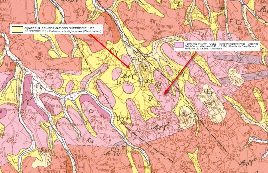
Ces deux ensembles sont des granites calco-alcalins à dominante potassique montrant principalement un faciès grossier à porphyroïde, avec des phénocristaux de feldspaths potassiques (orthose et microcline).
Ce sous-sol granitique a subit depuis sa mise en place une altération donnant des colluvions tardiglaciaires principalement composés d'argiles blanches ou kaolinite.
C'est sur cette couche intermédiaire que prendra ensuite place un sol superficiel particulier composé de landes humides et de tourbières.
► Le granite de Kersaint - Saint Renan
Le granite est une roche magmatique grenue non litée composée de minéraux visibles à l’œil nu :
- du quartz principalement (c’est de la silice pure SiO2)
- des micas : ce sont des minéraux feuilletés. On a essentiellement du mica noir (ou biotite) mais aussi du mica blanc (ou muscovite).
- des feldspaths : potassiques (orthose..) et plagioclases (albite, anorthite..).
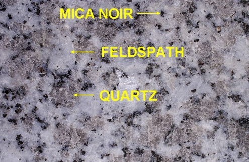
C'est la proportion et la taille de ces phénocristaux de feldspaths qui caractérise le granite porphyroïde sous jacent dans la région de Langazel.
► La kaolinite, produit de dégradation du felspath granitique
La kaolinite est le produit de la dégradation d'un des principaux minéraux du granite, le feldspath.
Ce minéral, très sensible à l'altération par l'eau va se transformer par hydrolyse en argiles (illite, kaolinite, gibbsite, smectites…).
Cette action est accélérée dans le cadre d'eau stagnante (creux de vallons, zones humides) comme c'est le cas dans le bassin versant de l'Aber Wrach qui prend sa source à Langazel.
Selon les conditions, ces hydrolyses pourront se faire selon des réactions différentes et donc conduire à des composés différents. Exemples d’hydrolyses de feldspaths :
Hydrolyse de l’orthose :
2 KAlSi3O8 (Orthose)+ 11 H2O = Si2O5Al2(OH)4 (Kaolinite) + 4 Si(OH)4 (Acide silicique) + 2 K+ + 2 OH-
Hydrolyse de l’anorthite :
2 CaAl2Si2O8 (Anorthite) + 4 CO2 (Dioxyde de carbone) + 6 H2O = 2 Ca++ + 4 HCO3- + 2 Si2O5Al2(OH)4 (Kaolinite)
La kaolinite ainsi formée est une argile blanche, friable et réfractaire, constituée de grains de silicates. A forte concentration, elle peut donner du kaolin, très utilisé pour la fabrication de la porcelaine.
L'argile possède la propriété d'être déformable quand elle est mélangée à l’eau. Elle est alors plastique et modelable. Sèche, elle devient rigide et friable.
Ce type d'argile est le plus courant en Bretagne, mais il existe d'autres types d'argiles comme l'argile verte, de type illite ou montmorillonite, ou l'argile rouge (limonite) dont la couleur varie en fonction des oxydes de fer qu'elle renferme.
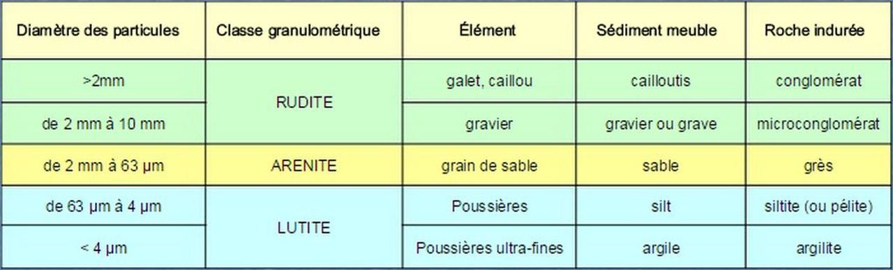
► Roche détritique et classe granulométrique
Il est possible de classifier les sédiments détritiques, dont la kaolinite, à l’aide de la granulométrie.
Cette analyse granulométrique permet de définir des classes de matériaux indépendamment de leur nature chimique, mais uniquement en fonction de la taille des grains qui la compose.
► La Kaolinite et les phyllosilicates, marqueurs de l'eau liquide sur Mars
La kaolinite, comme les autres phyllosilicates, sont le produit de l'altération par l'eau liquide de roches magmatiques, ce qui en font un marqueur de la présence de cette eau liquide en grande quantité et pendant une période longue.
La découverte sur Mars de grandes surfaces riches en phyllosilicates dans la région de Mawrth Vallis, région parmi les plus anciennes de la planète, est donc un élément déterminant pour prouver qu'il y a eu de l'eau liquide sur Mars en grande quantité et pendant une longue période.
C'est le programme OMEGA (Observatoire pour la Minéralogie, l’Eau, les Glaces et l’Activité) à bord de l'orbiteur Mars Express qui a détecté en premier ces larges dépôts de kaolinite, chlorites et illites.
Cette présence de kaolinite dans ces terrains altérés datés du Noachien (-3,6 milliards) sont riches en enseignements quant aux conditions atmosphériques de Mars à cette époque.
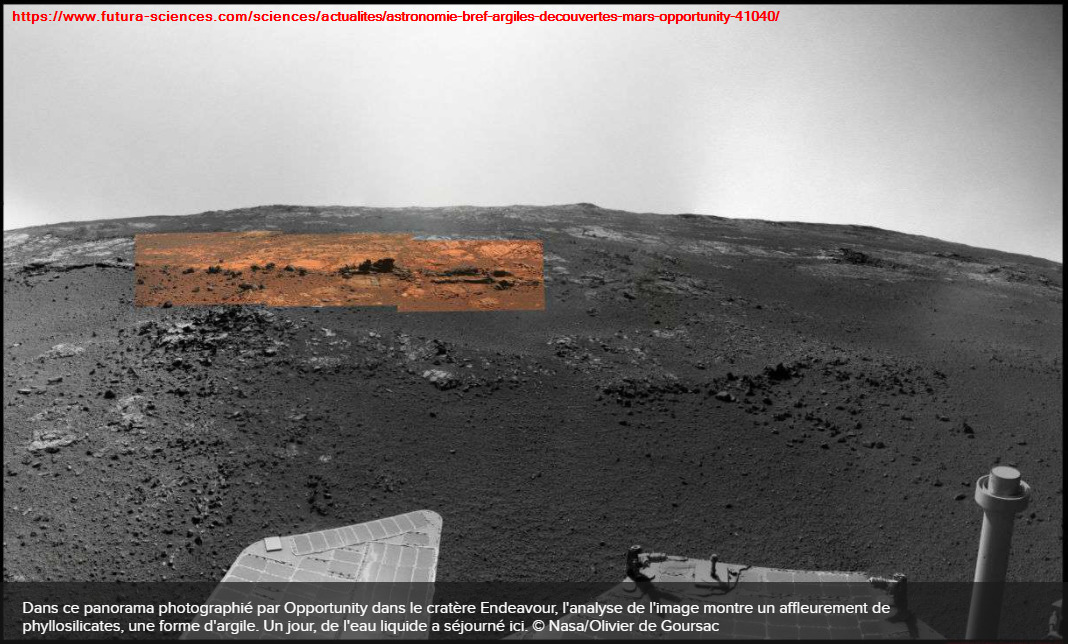
L'existence de phyllosilicates a également été confirmée en 2012 in situ par le rover Opportunity dans le cratère Endeavour, confirmant que de l'eau liquide y a séjourné.
► Local geological context
The Langazel region is characterized by a Hercynian plutonic bedrock, the Saint-Rénan - Kersaint Massif and the Saint-Renan Granite, fine facies.
These two groups are predominantly potassium-dominant calc-alkaline granites showing mainly a coarse porphyroid facies, with phenocrysts of potassium feldspars (orthose and microcline).
Since its establishment, this granite subsoil has undergone an alteration giving rise to tardiglacial colluvium mainly composed of white clays or kaolinite.
It is on this intermediate layer that a particular surface soil will then take place, composed of humid moors and peat bogs.
► The granite of Kersaint - Saint Renan
Granite is a grainy, unlined igneous rock composed of minerals visible to the naked eye: - mainly quartz (this is pure silica SiO2)
- micas: these are flaky minerals. We mainly have black mica (or biotite) but also white mica (or muscovite).
- feldspars: potassium (orthosis ..) and plagioclases (albite, anorthite ..).
It is the proportion and size of these feldspar phenocrysts that characterize the underlying porphyroid granite in the Langazel region.
► Kaolinite, degradation product of granite felspath
Kaolinite is the product of the breakdown of one of the main minerals in granite, feldspar.
This mineral, which is very sensitive to alteration by water, will be transformed by hydrolysis into clays (illite, kaolinite, gibbsite, smectites, etc.).
This action is accelerated in the context of stagnant water (valley hollows, wetlands) as is the case in the Aber Wrach watershed which has its source in Langazel.
Depending on the conditions, these hydrolyses may be carried out according to different reactions and therefore lead to different compounds. Examples of feldspars hydrolyses:
Hydrolysis of orthosis:
2 KAlSi3O8 (Orthose) + 11 H2O = Si2O5Al2 (OH) 4 (Kaolinite) + 4 Si (OH) 4 (Silicic acid) + 2 K + + 2 OH-
Hydrolysis of anorthite:
2 CaAl2Si2O8 (Anorthite) + 4 CO2 (Carbon dioxide) + 6 H2O = 2 Ca ++ + 4 HCO3- + 2 Si2O5Al2 (OH) 4 (Kaolinite)
The kaolinite thus formed is a white, friable and refractory clay, made up of grains of silicates. In high concentration, it can give kaolin, widely used for the manufacture of porcelain.
Clay has the property of being deformable when mixed with water. It is then plastic and moldable. Dry, it becomes rigid and crumbly.
This type of clay is the most common in Brittany, but there are other types of clay such as green clay, of the illite or montmorillonite type, or red clay (limonite), the color of which varies depending on the oxides. iron that it contains.
► Detrital rock and particle size class
It is possible to classify detrital sediments, including kaolinite, using particle size distribution.
This particle size analysis makes it possible to define classes of materials independently of their chemical nature, but only according to the size of the grains which compose it.
► Kaolinite and phyllosilicates, markers of liquid water on Mars
Kaolinite, like other phyllosilicates, is the product of the alteration by liquid water of magmatic rocks, which makes it a marker of the presence of this liquid water in large quantities and for a long period.
The discovery on Mars of large surfaces rich in phyllosilicates in the region of Mawrth Vallis, one of the oldest regions on the planet, is therefore a determining element in proving that there was liquid water on Mars in large quantities and for a long period.
It was the OMEGA (Observatory for Mineralogy, Water, Ice and Activity) program aboard the Mars Express orbiter that first detected these large deposits of kaolinite, chlorites and illites.
This presence of kaolinite in these altered terrains dated to the Noachian (-3.6 billion) are rich in lessons as to the atmospheric conditions of Mars at that time.
The existence of phyllosilicates was also confirmed in 2012 in situ by the Opportunity rover in Endeavor crater, confirming that liquid water has stayed there.
► Sources bibliographiques / Bibliographical sources
Les Questions / The Questions
La lecture attentive du descriptif de la cache, ainsi qu'une observation des éléments de terrain et un peu de déduction sont normalement suffisants pour répondre aux questions de cette EarthCache.
A careful reading of the description of the cache, as well as observation of terrain features and some deduction is usually sufficient to answer questions of this EarthCache.
Questions pour valider :"Planetary Geology on Earth : Kaolinite à Langazel"
Questions to validate: "Planetary Geology on Earth : Kaolinite of Langazel"
Point 1 : N 48° 30.653 W 004° 16.898
Vous voici devant un panneau présentant le site de Langazel, espace naturel protégé.
You are in front of a panel having the site Langazel, protected natural area.
- Question 1 : Quel adjectif qualifie cette zone (en français et en breton) et quel rapport avec le sol superficiel riche en kaolinite ?
- Question 1 : What adjective describes this area (in French and Breton) and what relationship with the rich topsoil kaolinite ?
Point 2 : N 48° 30.761 W 004° 16.767
Sur la droite du chemin, approchez vous du talus qui borde le fossé (voir photo). Prélever un peu de sol du talus dans la zone entourée en rouge.
On the right path, approach the slope bordering the gap (see photo). Take a little soil slope in the area circled in red.

- Question 2 : Quelle est la couleur principale de l'échantillon ?. Mouillez un peu votre échantillon (si celui-ci est sec) et essayez de le modeler pour en faire une boule. Y arrivez-vous ? Déduisez en la nature de cet élément.
- Question 2 : What is the main color of the sample?. Moisten slightly your sample (if it is dry) and try to shape it into a ball. Are you arrive? Deduct in the nature of this element.
- Question 3 : Observer les grains composant cet échantillon et estimer leur taille. En fonction de vos observations, déduisez en la classe granulométrique de cette couche de sol.
- Question 3 : Observe the grains in this sample and estimate their size. Based on your observations, deduct in the size range of this soil layer.
Point 3 : N 48° 30.832 W 004° 16.738
Observer le zone du sol entouré en rouge à cet endroit.
Observe the ground area circled in red there.

- Question 4 : Retrouver vous le même type sol (couleur, texture) qu'au WP3 ?
Le sol a cet endroit vous parait-il plutôt sec/filtrant ou plutôt hydromorphe (gorgé d'eau) ? Expliquer votre réponse
- Question 4 : Do you find the same type soil (color, texture) that WP3?
The soil here you seem it rather "dry/filter" or rather hydromorphe (waterlogged)? Explain your answer
Vous pouvez vous loguer sans attendre notre confirmation,
mais vous devez nous envoyer les réponses en même temps soit par mail via notre profil (
fafahakkai), soit via la messagerie geocaching.com (Message Center).
S'il y a des problèmes avec vos réponses nous vous en ferons part.
Les logs enregistrés sans réponses seront supprimés.Une photo de vous ou de votre GPS avec la tourbière en arrière plan sera la bienvenue, mais n'est pas obligatoire.
You can log this cache without waiting for our confirmation, but you must send us the answers at the same time, by e-mail via our profile (fafahakkai) or by the system of Message Center of geocaching.com.
If there is a problem with your answers we will notify you. The logs recorded without answers will be deleted.
A picture of you or your GPS with the bog in the background is welcome, but not mandatory.
Rappel concernant les « Earthcaches »: Il n'y a pas de conteneur à rechercher ni de logbook à renseigner. Il suffit de se rendre sur les lieux, de répondre aux questions ci-dessus et de nous renvoyer les réponses.
Reminder concerning "Earthcaches": there is neither a container to look for nor a logbook to sign. One need only go to the location, answer to the differents questions and send us the answers.