Une île - rocher sur la Loire... EarthCache
Une île - rocher sur la Loire...
-
Difficulty:
-

-
Terrain:
-

Size:  (other)
Please note Use of geocaching.com services is subject to the terms and conditions
in our disclaimer.
L'emblématique village de Béhuard.
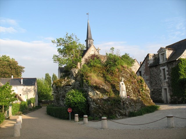 Cette île très singulière est pourtant emblématique de la Loire armoricaine.
Site entièrement inondable, seule l'église est protégée de la montée des eaux grace au rocher sur lequel elle est située...
Béhuard est une commune ligérienne de l'ouest de la France, qui se situe dans le département de Maine-et-Loire (49), entre les communes de Rochefort-sur-Loire et Savennières.
Petite cité de caractère, Béhuard est construit sur une ile de la Loire d'une superficie d'un peu plus de ( ? ) km².
Une des particularités de Béhuard est que tout le village, ou presque, est inondable.
Les Béhuardais doivent alors s'accommoder des caprices du fleuve qui est monté jusqu'à 6 m 78 en 1910 dans les rues du village, comme en témoigne le niveau d'eau installé à côté de l'église.
A l’origine, un mini-archipel:
Imaginerait-on, en effet, que l’île est née de l’éclatement d’un ( ? ) il y a ( ? ) millions d’années .
« Il existe trois éléments remarquables de cet accident géologique:
Les deux symétriques de Béhuard se situent à Rochefort-sur-Loire, juste en face de l’île sur la rive sud, et le rocher est sans conteste l’élément constitutif du site.
À l’origine île principale d’un mini-archipel que les alluvions ont fini par « agréger », l’émergence a de tout temps été considérée comme un lieu spirituel. 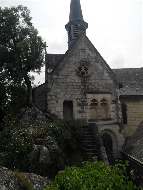 RAPPEL: PAS DE BOITE A TROUVER SUR PLACE...
POUR VALIDER CETTE CACHE, REPONDEZ AUX QUESTIONS SUIVANTES:(en vous aidant et en complétant le descriptif, et bien entendu sur le site)
1) Au WP 1: Quel type de roche est exposée ? (celle ou est construite l'église)
RAPPEL: PAS DE BOITE A TROUVER SUR PLACE...
POUR VALIDER CETTE CACHE, REPONDEZ AUX QUESTIONS SUIVANTES:(en vous aidant et en complétant le descriptif, et bien entendu sur le site)
1) Au WP 1: Quel type de roche est exposée ? (celle ou est construite l'église)
2) De quand date l'ile ?
3) De quel phénomène géologique est-elle issue ?
4) Quelle est la superficie de l'ile ?
5) Nom des embarcations utilisées en cas de crues ?
6) Au WP 2: Altitude au niveau de l'échelle de crues ?
7) Photo optionnelle devant le rocher !!!
Loguez cette cache "Found it" et envoyez-moi vos propositions de réponses soit via mon profil, soit via la messagerie geocaching.com (Message Center), et je vous contacterai en cas de problème.
 The iconic town of Béhuard.
This very singular island is nevertheless emblematic of the Breton Loire.
Site completely flooded, only the church is protected from the rising waters thanks to the rock on which it stands ...
Béhuard ligérienne is a town in western France, located in the department of Maine-et-Loire (49) , between the towns of Rochefort-sur-Loire and Savennières.
Small town character, Béhuard is built on an island in the Loire with an area of just over (?) Km².
One of the peculiarities of Béhuard is that the whole village, almost, is flooded.
The Béhuardais must then accommodate the whims of the river which rose to 6 m 78 in 1910 in the village streets, as evidenced by the level of water installed next to the church.
Originally a mini-archipelago:
we imagine, in fact, that the island was born from the breakup of a (?) Ago (? ) millions of years.
"There are three notable features of this geological accident
Béhuard both symmetrical fall in Rochefort-sur-Loire, just opposite the island on the south shore, and the rock is undoubtedly part of this site.
On the main island originally a mini-archipelago that alluvium eventually "aggregate", emergence has always been considered a spiritual place.
TO CONFIRM THE CACHE, ANSWER THE FOLLOWING QUESTIONS: (helping you and completing the description and of course on the site)
1) At WP 1: What type of rock is exposed? (Or that the church was built)
2) When was the island?
3) What geological phenomenon is she after?
4) What is the area of the island?
5) Name of craft used in case of flooding?
6) In WP 2: Elevation scale flood level
? 7) Optional photo before the rock !!!
phones Sign the cache "Found it" and send me your answers proposals either via my profile or via email geocaching.com ( Message Center), and I will contact you in case of problems.
Informations complémentaires/Further information:
Inscrite au patrimoine mondial de l’Unesco dans le cadre du Val de Loire, membre du réseau Natura 2000, soumise au PPRI (Plan de prévention risque inondation), c’est aussi une “petite cité de caractère”. Respecter les recommandations du site (se reférer à la réglementation des panneaux)
*****************************************************
World Heritage of Unesco in the Loire Valley, a member of the Natura 2000 network, subject to the IRPP (risk prevention plan flood), it is also a "small town character."
Follow the recommendations of the site (we also refer to the regulation of signs)
Additional Hints
(Decrypt)
Zrepv qr ar cnf qvihythre qr cubgbf qh JC 1.
Cerarm yr grzcf qr ivfvgre pr zntavsvdhr ivyyntr bh q'nhgerf pnpurf ibhf nggraqrag...
************************
Gunax lbh gb jvguubyq cvpgherf bs JC1.
Gnxr gvzr gb ivfvg guvf ornhgvshy ivyyntr be bgure pnpurf njnvg lbh ...