Holy Island (Inis Cealtra) - A potted history
This island, which is also called the "Island of the Seven Churches," is in Lough Derg, between the counties of Clare and Galway.
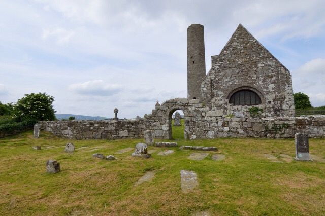
The first monastery on the island was founded by St. Colum around 520. The second monastery on Inish Cealtra was founded by St. Caimin who was a prince and stepbrother of Guaire, the King of Connaught. He was Bishop-Abbot of Inis Cealtra and some accounts claim he was the first Bishop of Killaloe. In 836 the Danes led by Turgesius pillaged the island, killing many of the monks. The Danes attacked again under the leadership of Tomran in 922. Brian Boru's brother Marcan was Bishop-Abbot of Inis Cealtra until his death in 1003. The building of St. Caimin's Church and the round tower is ascribed to Brian Boru. Today the island is a popular destination for pilgrims and tourists.
Things to see
I'm going to list the main attractions here, there are many information panels on the island and plenty more information is available on the internet if you are interested and want to find out more about this fascinating island.
The round tower - missing its cone cap, the round tower remains unfinished. Legend has it that the stone mason was distracted by a beautiful blonde witch and so never finished the tower.
St. Caimin's Church - part of which dates back to the late tenth century. There is a wonderful Romanesque doorway in the west wall. While some of the restoration work here feels a little heavy handed it is impressive nonetheless.
The Saints Graveyard - in the grounds of St. Caimin's church, the saint's graveyard is on the east side of the church and has grave markers dating back to the 11th century. The nineteenth century graveyard is on the south side of the church and is still in use today.
The Oratory - Situated in the Saints' Graveyard is the oratory, "teampall na bhfear ngonta", the church of the wounded men, an early eighteenth century mortuary chapel of the O'Gradys whose motto was "wounded but not vanquished."
The Confessional - It was used as a confessional during the pilgrimages of the eighteenth and nineteenth centuries but its original use is still unknown.
The Pilgrims Path - a continuous low earth and stone bank beginning near St. Caimin's Church and continuing somewhat in an arc to St. Michael's. It afforded the pilgrim a dry passage in an otherwise sodden and sticky terrain during wet weather.
St. Michael's Church - no longer extant but was situated on the highest point of the Island and was likely to have been a children's burial ground. A raised D shape enclosure is all that can be seen today.
The Baptism Church - a small Romanesque church ruin is due south of St. Michael's and two-thirds of the way to St. Mary's. It is enclosed by a stone wall rebuilt in more recent times.
St. Mary's Church - Large church ruin is almost due south of St. Caimin's and the round tower. It belongs to the early thirteenth century and is the largest building on the island. Replaced St. Caimin's as the parish church in 1210.
Bullaun Stones - stones with a bowl shape depression. There are five on the island.
Getting there
The shortest route to Holy Island is from Knockaphort Pier (marked as a parking option below) but boating enthusiasts may prefer the longer trip from Mounshannon. Because of rocks it is advisable to travel to the island (or at least land) by canoe, kayak, dinghy or other vessel with a similarly shallow draft. There are two piers on the island - one can be seen from Knockaphort Pier on the north west of the island, the other is on the east side of the island. Trips to the island are also available from Mountshannon. When on the island you will see well beaten tracks to the main attractions from both piers but I would suggest taking a look at some aerial photography of the island on google earth/bing maps/osi.ie to get a good overview before you go. There are no facilities on the island so bring along anything you might need such as water, snacks etc.
Please note that dogs are not allowed on the island.
The cache is a 450mL tupperware box containing a pencil, logbook and some small items of swag. The area is under some tree cover so GPS may not be super accurate.