O Cânion Pirituba
O Cânion Pirituba está localizado em Itapeva no sudoeste do Estado de São Paulo, numa área de transição entre Cerrado e Mata Atlântica. É aqui onde se localiza uma de suas extremidades que se estendem até o estado do Paraná. Distante apenas a 40 km do centro da cidade, o Cânion é denominado como Escarpamento Estrutural de Furnas, uma formação em arenito que constitui em um raro Sítio Geomorfológico no Brasil. O cânion é um depósito glacial marinho que se fundiu ao longo de milhares de anos. Neste passeio você poderá contemplar os mirantes com seus paredões de até 120 m de altura e se refrescar nas cachoeiras e piscinas naturais de águas cristalinas.
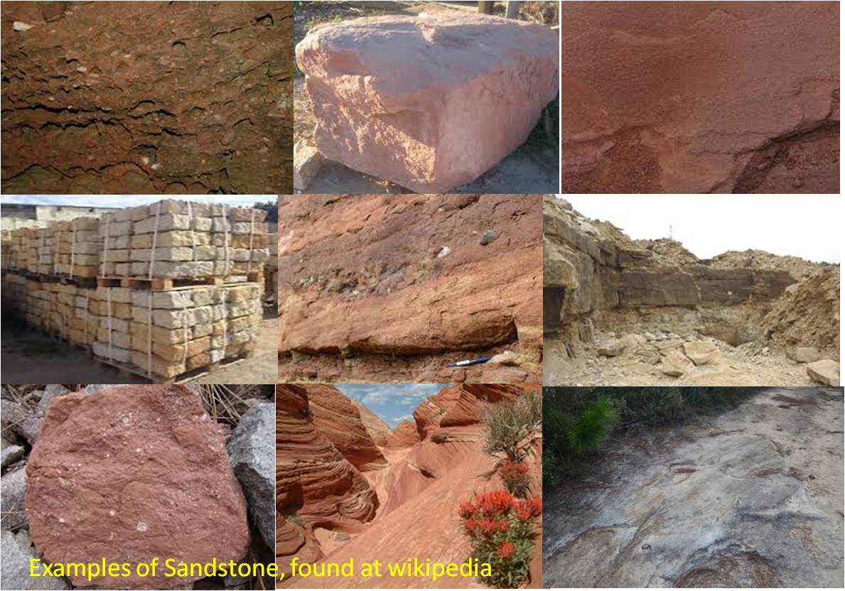
Arenito - o que é?
O arenito é uma rocha sedimentar clástica com uma quota de pelo menos 50% granular areia. Os grãos de areia são grandes, por definição, entre 0,063 milímetros e 2,0 milímetros e são compostos por diferentes minerais, mas principalmente por quartzo. 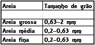 O termo areia é definida com um determinado tamanho de grão. Se um componentes do arenito com diâmetro superior a 2 mm, ele será chamado de arenito conglomeratico. Arenitos com porções de tamanhos de grão abaixo 0.063 mm ou 0.002 mm são chamados arenitos argilosos. Devido às geleiras, vento e água correr a base. Isso deixou pequenas partículas. Através do vento e da água, eles foram transferidos, até que se reuniram aqui. Ao longo do tempo, o resultado foi de arenito. Que é formado por cimentação (cimentação) da areia solta e misturas de partículas mais grossa ou mais finas de sedimentos (argila, silte, seixos).
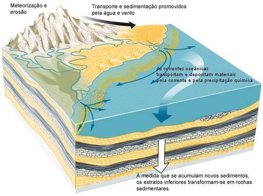
A compactação de sedimentos novos e minerais dissolvidos na água do mar ou de rios, ou que estão incluídos no próprio arenito, vem solidificar a areia. Aumentando a compactação pela camada de sobreposição de sedimentos. A areia solta é comprimida e reduz o volume de póros. Ao mesmo tempo, começa uma remoção de água do sedimento. Parte da água abundante intercalada é espremida para fora, acima das camadas de sedimentos. A ligação das partículas é efectuada pelo ligante. A ligação também chamada de cimento. E a liga ou colagem chamado de cimentação. Que ocorre em cooperação de processos químicos criados pela compressão da estrutura de uma rocha sólida sedimentar não consolidada. Este processo ocorre lentamente. Demora entre algumas décadas e vários milhões de anos. Este processo de formação rochosa é chamado como diagénese. Que são cores diferentes no arenito causadas por misturas de minerais como a hematita (vermelho, marrom), limonite (amarelo), glauconita (verde escuro). Aqui na região do Canyon Pirituba nós sempre iremos encontrar os bancos de arenito que nos fornecem informações sobre do que eles são feitos e sua resistência.
Eu ficaria muito feliz de uma foto sua no local. Para logar este cache com sucesso, favor responder as perguntas seguintes e enviar nos por messagem. Após isso você poderá logar diretamente. Se tiver algo de errado nós entraremos em contato.
1.) Debaixo dos seus pés, passamos por cima de uma laje de arenito. Você pode ver as diferentes camadas? Qual é a espessura?
2.) Pelo fato do arenito por aqui não ser muito resistente, há areia solta por aqui. Determinar o tamanho dos grãos da areia.
3.) Qual é a cor de arenito? Qual mineral poderia ser responsável pela cor?
4.) Você acha, que o arenito é adequado para a construção de edifícios ou esculturas? Por quê?

The Pirituba Canyon
The Canyon Pirituba in Itapeva in the southwest of the state of São Paulo, is in a transition area between Cerrado and Atlantic Forest. The canyon is called Structure Escarpment Furnas and is training in sandstone, which is a rare geomorphological phenomenon in Brazil. The canyon is a marine glacier deposit, that melted over thousands of years. Here you may admire the viewpoints with its up to 120m high cliffs, cool waterfalls and natural pools with crystal clear water. Geologists suspect the emergence of sandstone 2 billion years ago. The division of Tepuis-sandstone in Roraima and Kukenam probably happened 160 million years ago, as the supercontinent Gondwana broke apart and South America drifted westward. Probably a great earthquake was the cause of this division. Later during the Paleozoic spacious pool incurred. So also the Parana Basin. This landscape contains several thousand meters thick, preferably terrestrial-fluvial sediments, carried out in the individual short-term marine incursions. The largest sedimentation took place in Devon and Upper Carboniferous.
Sandstone – what is it?
Sandstone is a clastic sedimentary rock with a share of at least 50% sand granular. The sand grains are large by definition between 0,063mm and 2.0mm and are made of different minerals, but mostly of quartz.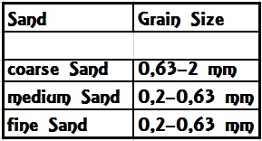 The term sand is defined with a certain grain size. If a sandstone components whose diameter exceeds 2 mm, it will be referred to as conglomeratic sandstone. Sandstones with portions of grain sizes below 0,063 mm or 0,002 mm are called argillaceous sandstones. Due to the glaciers, wind and water eroded the bedrock. This left small particles. Through wind and water, they were moved, until she gathered here. Over time, the result was sandstone. It is formed by cementing (cementation) of loose sand and admixtures of coarser or finer sediment particles (clay, silt, pebbles).
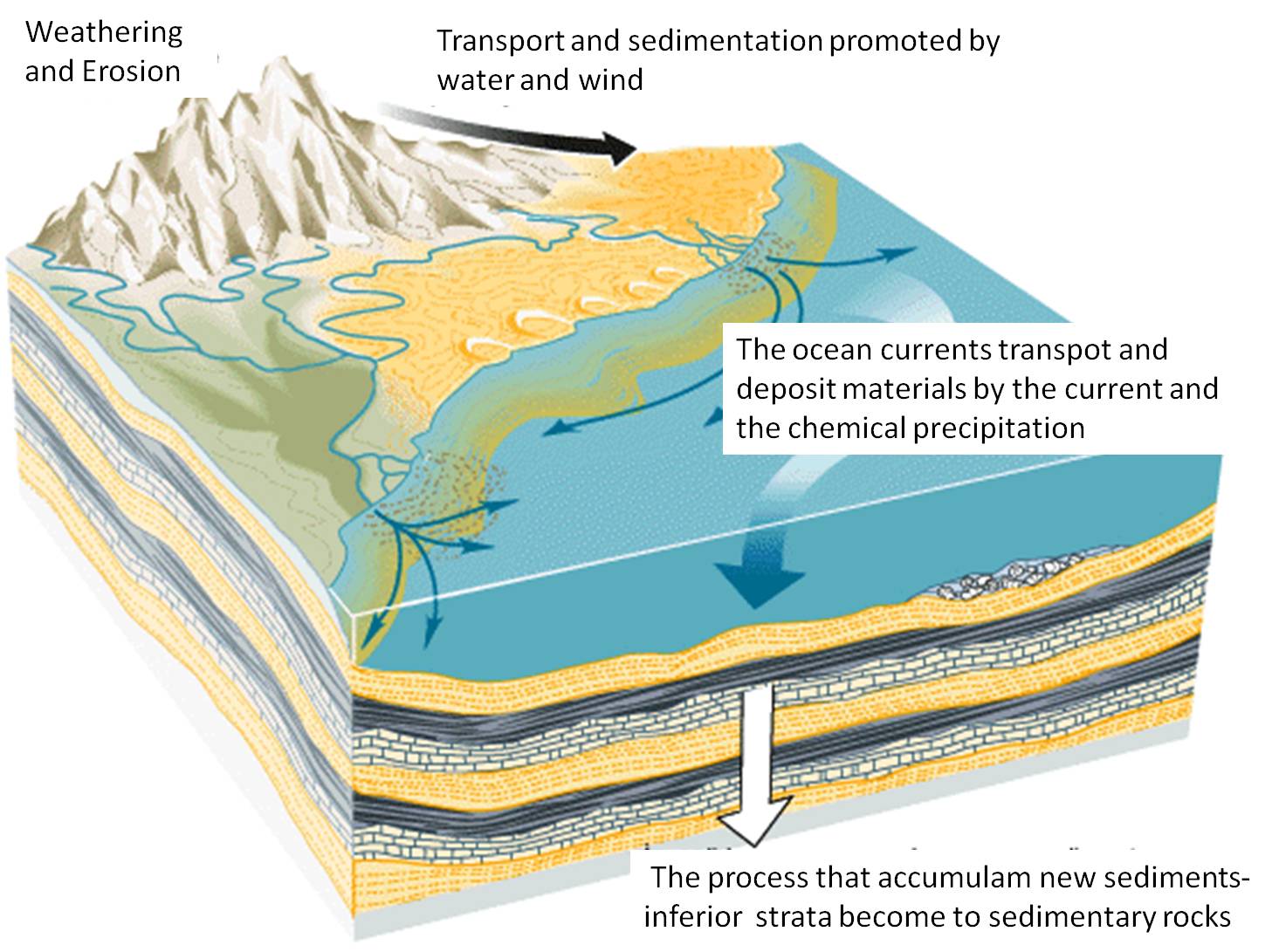
The tamper head of younger sediments and minerals that are dissolved in the sea or ground water, or are included in the sandstone itself, it comes to solidify the sand. Increased tamper head by overlying sediments first leads to compaction. The loose sand is compressed and reduces the pore volume. Same time, begins a dewatering of the sediment. Part of the abundant pore water is squeezed out of the sediment upwards. The particle bond is effected by the binder. The binder is also referred to as a cement. The bond is called cementation. In cooperation of chemical processes created by the compression of the structure of an unconsolidated sediment a solid rock. This process is different from quickly. It takes between a few decades and several million years. This process of rock formation is called as diagenesis. Different colors in the sandstone caused by admixtures of minerals such as hematite (red, brown), limonite (yellow), glauconite (dark green). Here in the region of Pirituba Canyon we will always find the sandstone banks that provide us with information about what they are made and how hard they are.
To log this cache, go to this location and answer the following questions. Then post a photo of you at the location to your log. Of course, if you do not want to appear in the photo, a personal item in the photo is enough proof of your presence. (According to the Earthcache Guidelines, photo-proofing has been required since June 2019.)
After that you can give your log directly. If anything is not ok, we will contact you.
1.) Directly at your feet, we go over a sandstone slab. Can you see different layers? How thick are you?
2.) The sandstone here is not too resistant, you can see some loose sand around. Can you tell the size of sand grains?".
3.) What is the color of sandstone? Which mineral could be responsible?
4.) What do you think, is the sandstone suitable for the construction of buildings or sculptures? Why?

Der Pirituba Canyon
Der Canyon Pirituba in Itapeva im Südwesten des Bundesstaates São Paulo, liegt in einem Übergangsbereich zwischen Cerrado und Atlantic Forest. Der Canyon wird als Struktur Escarpment Furnas bezeichnet und ist eine Ausbildung in Sandstein, die in Brasilien eine seltene Geomorphologische Erscheinung ist. Der Canyon ist ein Marine-Gletscher-Lagerstätte, die über tausende von Jahren schmolz. Hier könnt ihr die Aussichtspunkte mit seinen bis zu 120 m hohen Klippen, kühlen Wasserfällen und natürlichen Pools mit kristallklarem Wasser bewundern. Geologen vermuten die Entstehung des Sandsteins vor 2 Milliarden Jahren. Die Teilung des Tepuisandsteines in Roraima und Kukenam geschah vermutlich vor 160 Millionen Jahren, als der Urkontinent Gondwana auseinanderbrach und Südamerika nach Westen driftete. Wahrscheinlich war ein gewaltiges Erdbeben Ursache dieser Teilung. Später im Laufe des Paläozoikums sind weiträumige Becken entstanden. So auch das Parana-Becken. Diese Landschaft enthält mehrere tausend Meter mächtige, vorzugsweise terrestrisch-fluviale Sedimente, in die einzelne kurzfristige marine Vorstöße erfolgten. Die größte Sedimentation fand im Devon und Oberkarbon statt.
Aber was ist Sandstein?
Sandstein ist ein klastisches Sedimentgestein mit einem Anteil von mindestens 50 % Sandkörnern. Die Sandkörner sind per Definition zwischen 0,063mm und 2,0mm groß und bestehen aus verschiedenen Mineralen, meistens jedoch aus Quarz.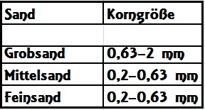 Mit dem Begriff Sand wird also eine bestimmte Korngrößen definiert. Führt ein Sandstein Komponenten, deren Durchmesser 2 mm übersteigt, wird er als Konglomeratischer Sandstein bezeichnet. Sandsteine mit Anteilen von Korngrößen unter 0,063 mm oder 0,002 mm werden tonige Sandsteine genannt. Bedingt durch die Gletscher, Wind und Wasser erodierten die Grundgebirge. Übrig blieben kleine Partikel. Durch Wind und Wasser wurden sie fortbewegt, bis sie sich dann hier sammelten. Im Laufe der Zeit entstand daraus der Sandstein. Er entsteht durch die Verkittung (Zementation) von lockerem Sand und Beimengungen groberer oder feinerer Sedimentpartikel (Ton, Silt, Gerölle).
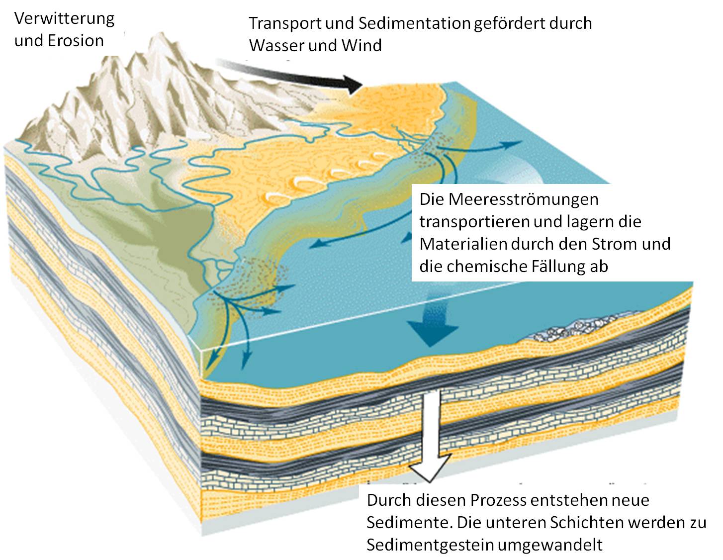
Durch den Auflastdruck der jüngeren Ablagerungen und durch Mineralen, die im Meer- oder Grundwasser gelöst sind, oder auch im Sandstein selbst enthalten sind, kommt es zur Verfestigung des Sandes. Zunehmender Auflastdruck durch überlagernde Sedimente führt zunächst zu einer Kompaktion. Der lockere Sand wird verdichtet und das Porenvolumen verringert. Gleichzeitig erfolgt eine Entwässerung des Sediments. Ein Teil des reichlich vorhandenen Porenwassers wird aus dem Sediment nach oben herausgepresst. Die Kornbindung wird durch das Bindemittel bewirkt. Das Bindemittel wird auch als Zement bezeichnet. Die Bindung nennt man Zementation. Chemische Vorgänge lassen in Verbindung mit der Verdichtung des Gefüges aus einem Lockersediment ein Festgestein entstehen. Dieser Prozess läuft unterschiedlich schnell ab. Er dauert zwischen wenigen Jahrzehnten und mehreren Millionen Jahren. Man bezeichnet den Vorgang der Gesteinsbildung als Diagenese. Verschiedene Farben im Sandstein entstehen durch Beimengungen von Mineralien wie zb Hämatit (rot, braun), Limonit ( gelb), Glaukonit ( dunkelgrün). Hier im Bereich des Pirituba Canyon treffen wir immer wieder auf Sandbänke, die uns Aufschluss darüber geben, woraus sie bestehen und wie hart sie sind.
Ich würde mich über ein Foto von Euch vor Ort freuen (optional). Um diesen Cache zu loggen, begib dich zu dieser Location und beantworte nachfolgende Fragen. Anschließend postet zu eurem Log bitte noch ein Foto von euch an der Location. Wenn ihr selbst nicht auf dem Foto erscheinen wollt, reicht natürlich auch ein persönlicher Gegenstand auf dem Foto als Beweis eurer Anwesenheit. (Laut Earthcache Guidelines ist die Forderung eines Fotobeweises seit Juni 2019 wieder erlaubt.) Danach könnt Ihr sofort loggen. Wenn irgendetwas nicht in Ordnung sein sollte, melde ich mich.
1.) Direkt zu euren Füßen gehen wir über eine Sandsteinplatte. Kannst du verschiedene Schichten erkennen? Wie dick sind sie?
2.) Da der Sandstein hier nicht sehr fest ist, liegt durch Erosion bedingt auch loser Sand herum. Bestimme seine Korngröße.
3.) Welche Farbe hat der Sandstein? Welches Mineral könnte dafür verantwortlich sein?
4.) Wenn Was meint Ihr, eignet sich der Sandstein zum Bau von Gebäuden oder Skulpturen? Warum?
source directory:
-Wikipedia
-Mineralienatlas.de
-spektrum.de/lexikon/geographie
-Picture by my own
-Graphics: by my own and www.alunos.esffl.pt/rochas