Combe Saint Joseph : Initiation à la géologie locale
Combe Saint Joseph: Introduction to local Geology
FR
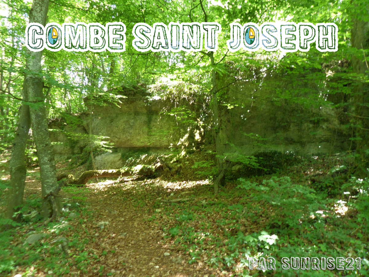
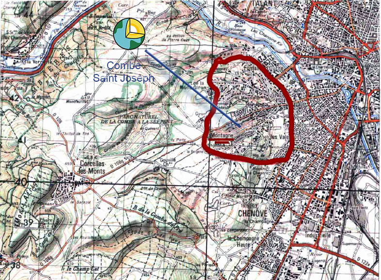
Je vous propose une EarthCache simple mais instructive en suivant le sentier initiation à la Nature de la Ville de Dijon sur une combe dijonnaise : La Combe Saint Joseph.
Une combe est une vallée creusée par l’érosion des roches calcaires du plateau
Les observations forment une boucle de 1.8 Km avec peu de denivelé : pensez tout de même à prendre de bonnes chaussures, notamment un hiver après temps de pluie le sol peu être à glissant à un endroit.
La balade permet de découvrir les deux versants, une source ; une flore et faune atypique, et possède un kiosque ainsi que des bancs si vous souhaitez pique-niquer.
Contexte :
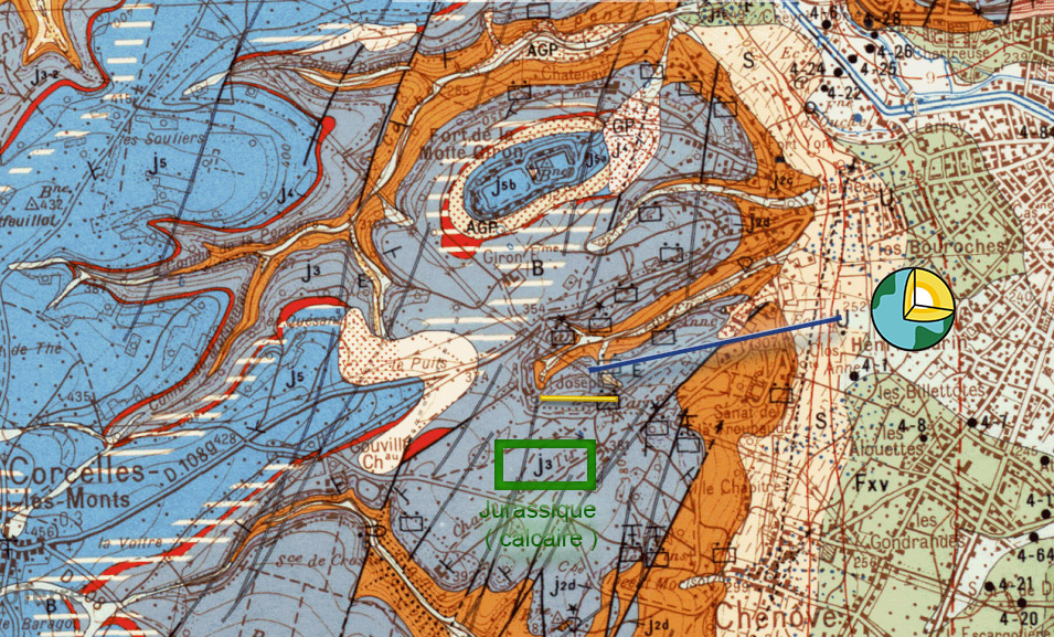
Le quartier de la Montagne s’élève sur le rebord oriental du plateau de Côte d’Or constitué par les calcaires et les marnes du Jurassique moyen et supérieur. Il borne la terminaison nord de la Côte. A la base du versant sous les formations superficielles de piedmont, se trouve la grande fracture bordière du fossé tectonique bressan. Au-delà vers l Est, les couches jurassiques disparaissent en profondeur sous les formations conglomératiques et marno-argileuses tertiaires de remplissage du fossé et sous les alluvions quaternaires. Des alluvions grossières, sablo-graveleuses, s’étalent au débouché de la haute vallée de l’Ouche


Structure tectonique
Les couches sont inclinées vers l’Est. Ainsi les limites de couches apparaissent horizontalement sur le versant nord-sud de la Côte alors qu’elles remontent sur les versants lorsqu’ on se dirige vers l’Ouest. C’est cette structure qui permet au Comblanchien d affleurer dans la Combe Saint Joseph jusqu’à son extremité Ouest et aux carrières de Grenu de l’élever progressivement dans cette direction.
Rappel concernant les « Earthcaches »: Il n'y a pas de conteneur à rechercher ni de logbook à renseigner. Il suffit de se rendre sur les lieux et d'exécuter les requêtes du geocacheur
Loguez cette cache "Found it" et envoyez-moi vos propositions de réponses soit via mon profil, soit via la messagerie geocaching.com (Message Center), et je vous contacterai en cas de problème.
Il est aussi apprecié d'avoir des photos des geocacheurs sur lesles lieux des EarthCache. Sentez vous inspiré de poster des photos de vous lors de cette visite ( optionnelle mais sympa)
Question :
Question 1 Pourquoi trouve t on une foret ici?
Question 2 est ce que le la strate hypogée ?
Question 3 Pourquoi trouve ton une source ici ?
Question 4 : Que trouvait on ici il y a plusieurs millions d’années ?
Question 5 : Quel phénomène détruit les roches ? Citer 3 exemples
Question 6 : Que trouve ici et quelle est son origine ?
Question 7 : De quoi se compose le sol ?
Question 8 ( facultatif ) : Une / Des photos sympathique(s) ?
-----
EN
I propose a simple but instructive EarthCache following the path introduction to Nature in the City of Dijon on a Dijon Combe: Combe Saint Joseph.
A valley is a valley carved by the erosion of limestone plateau
The observations form a loop of 1.8 km with low gradient: still remember to take good shoes, especially after a winter of rain to the ground shortly be rolling in one place.
The walk to discover the two sides, a source; flora and fauna unique, and has a kiosk and benches if you want a picnic.
Be carrefull, I translate this EC in English, but the boards when you can get the answers in the way are in French..But this hiking is good, perhaps think about bring a translator ;)
Background:
The area of the Mountain rises on the eastern edge of the tray Coast Golden consisting of limestone and marl of the Middle and Upper Jurassic. It borders the northern termination of the Coast. At the base of the slope beneath the surface formations of piedmont, is the large bordière fracture Bresse graben. Beyond to the east, the Jurassic layers disappear deep under the conglomeratic formations and tertiary marl and clay of the ditch and fill in Quaternary alluvium. Coarse silt, sand and gravel, spread at the opening of the high valley of Ouche.
Tectonic structure
The layers are tilted eastward. Thus the boundary layers appear horizontally on the north-south slopes of the Côte then they go back on the slopes when we head west. It is this structure that allows the flush of Comblanchien in Combe Saint Joseph West to its extremity and Grenu careers to raise gradually in that direction.
Reminder concerning "Earthcaches": there is neither a container to look for nor a logbook to sign.
Log in this cache " Found it " and send me your answers proposals or via my profile or via geocaching.com messaging (Message Center ) , and I will contact you in case of problems .
We also enjoy seeing photographs of people visiting this EarthCache. Please feel free to log photos of your visit...(this is entirely optional but funny)
Question
Question 1 Why is your one forest here?
Question 2 What is the stratum Hypogeum?
Question 3 Why is there a source here?
Question 4: What we found here a few million years?
Question 5: Which nomenon destroyed the rocks? Quote 3 examples
Question 6: What is here and what is its origin?
Question 7: What makes up the soil?
Question 8 (optional): One or more nice photo (s)?
Sources
http://infoterre.brgm.fr/
https://fr.wikipedia.org/wiki/Portail:Dijon/Relief_et_g%C3%A9ologie
JOYEUX & HAPPY EARTHCACHING !