EDUCATIONAL LOGGING REQUIREMENTS
In order to substantiate your visit and comply with the educational requirement for Earth Caches you have to submit your answers to the following questions to the cache developers via their profile. The Difficulty rating of this cache is based on the amount of reading that is required to be able to answer the questions. The Terrain rating has been increased as two waypoints need to be visited.
For purposes of logging this cache you must answer the following six questions.
1) What is the approximate length of the Sundays River?
2) How many geological regions does the river pass through?
3) What Group of rock is weathered into a tombstone shape?
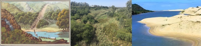
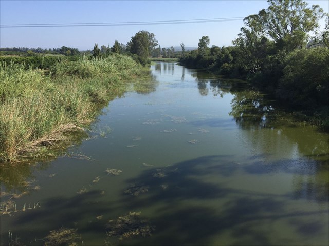
4)Stand at the published coordinates and look down the river towards the sea. Describe the river bed and banks (locational question).
5) Where does the water come from that is flowing in the river below?
6) Visit Waypoint 2 at the estuary. Look to the South. What formation are you looking at? (Hint-part of the Algoa Formation)
|
Brief History
The area around what is now called Algoa Bay was first settled by hunting and gathering people ancestral to the San at least 100,000 years ago. Around 2,000 years ago, they were gradually displaced or assimilated by agriculturalist populations ancestral to the Xhosa, who migrated into the region from the north. The first Europeans to have visited the area were Portuguese explorers Bartholomeu Dias, who landed on St Croix Island in Algoa Bay in 1488 and Vasco da Gama who noted the nearby Bird Island in 1497. For centuries, the area was simply marked on navigation charts as "a landing place with fresh water".
The largest river flowing into Algoa Bay is the Sundays River.
The Khoisan people originally named this river Nukakamma (Grassy Water) because the river's banks are always green and grassy despite the arid terrain that it runs through.
It is said to be the fastest flowing river in the country but there does not seem to be any scientific basis for this claim.
Flow path
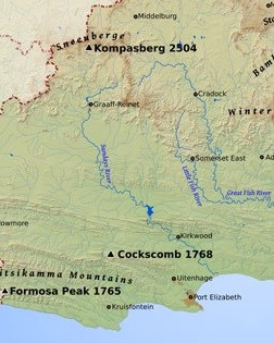 The Sundays river is sourced in the Sneeuberge, to the east of Compassberg at an altitude of 2 150 meters above sea level. Official charts show the river being sourced both off the Loodsberg and Wapadsberg on either side of the N9 north of Graaff Reinet.
It flows south through Graaff Reinet (almost encircling it) and the Nqweba Dam (previously known as Vanryneveld's Pass Dam) then to Jansenville where it turns south-east to the Darlington Dam, (previously Lake Mentz). Thereafter it runs through a kloof in the Zuurberg Mountains passing Kirkwood. Turning in a more southerly direction at Addo it reaches the coast at Colchester where it turns through two ninety degree bends before entering the Indian Ocean.
The Sundays River is approximately 310 km in length.
Fish-Sundays Canal Scheme
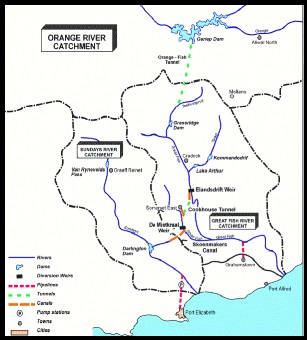 The Fish River-Sundays River Canal Scheme consists of a canal and tunnel system which supplies water from the Orange River to the Great Fish River Valley and subsequently to the Sundays River Valley in order to supplement the existing water supply of the Eastern Cape. The water from the Gariep Dam is fed via a tunnel to the Great Fish River. At the Elandsdrift Weir in the Great Fish it is fed via a canal and tunnel to the Small Fish River. At the De Mist Weir it is fed using a canal to a tributary of the Sundays River into the Darlington Dam.Since 1992 the water from the Sundays River Valley has been supplied to the Nelson Mandel Bay Municipality.
Catchment
 The catchment area of the Sundays River is approximately 22 000 km2. Sheep farming and citrus cultivation are the main activities in the catchment and along the entire river.
The mean annual precipitation in the region is about 320 mm, categorizing the catchment as semi-arid. This is not surprising seeing that the major part of the area is in the Karoo.
The mean annual runoff (MAR) is about 186x106 m3 while the two dams in the catchment retain collectively about 140% of the MAR.
Dams
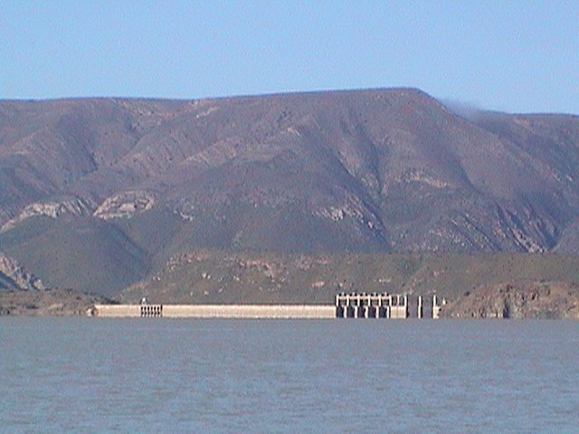 There are two major dams on the Sundays River, the Nqweba and Darlington.
Nqweba Dam is an earth-fill type, established in 1925. The dam has a capacity of 46,369,000m³ and a surface area of 10.285km², the wall is 46m high and 357m long.
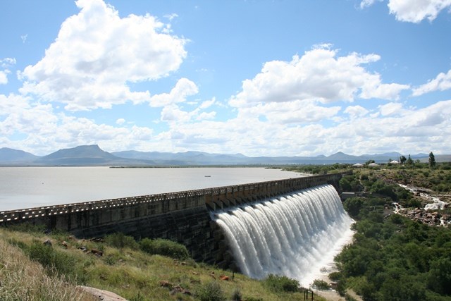 Darlington Dam is a gravity type, established in 1922 and renovated in 1952. The dam has a capacity of 187,000,000m³ cubic metres with a 35.3m high wall. Its primary purpose is for irrigation, industrial and domestic use.
Vegetation
If one starts at the source the river flows through the Karoo sheep farming areas and the Karoo grasslands. This changes slowly to the Noorsveld vegetation in the Jansenville area. After the Darlington dam there is a section of indigenous riverine forests and mountain fynbos (Groot Thicket) in the Zuurberg Mountains. Here the tree cycad Encephalartos horridus is found growing in rocky quartzite outcrops.
As the river flows through the Kirkwood/Addo area there is little of the indigenous Sundays Thicket remaining due to the extensive removal for citrus farming. At the mouth the vegetation consists of Dune Strandveld.
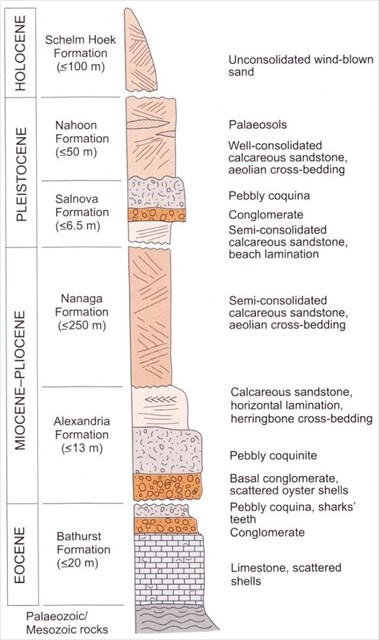
Geology
If one looks at the simplified geological map of the area it looks as if the Sundays River crosses only five geological formations. Starting at the source these are the Beaufort Group, the Dwyka/Ecca Group, the Cape Supergroup, the Uitenhage group and the Algoa Group of Coastal Cenozoic Deposits. This necessitates a relatively lengthy geological section to the Earth Cache.
The river is sourced in the Sneeuberg Mountains which comprise the sediments of the Beaufort group. They were deposited around 250 million years ago (mya) in the swampy conditions on the Gondwana floodplain and consist of siltstones, mudstones and shales. This area is dominated by dolerite sills which give the Karoo Mountains their typical flat topped look.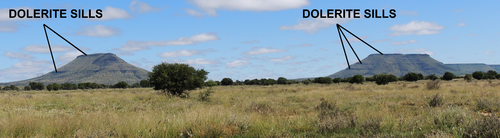
The hard dolerite has lower levels of weathering than the surrounding sedimentary rock, the reason for the high mountains in this area.
As one moves south along the river there is less dolerite resulting in more noticeable vlaktes (plains).
As one approaches the Darlington Dam the geology changes. Here one can see rocks of the Ecca and Dwyka groups. The Dwyka Group is overlain by the Ecca and Beaufort Group rocks. About 300 mya Africa was covered with glaciers. These glaciers migrated south/south-west. As they moved they ripped up rock which was deposited when the glaciers melted. This rock cemented to become tilllite of the Dwyka Group, which Group occurs as a horizontal band along the northern edges of the Zuurberg mountain range and along the southern shores of Darlington Lake.
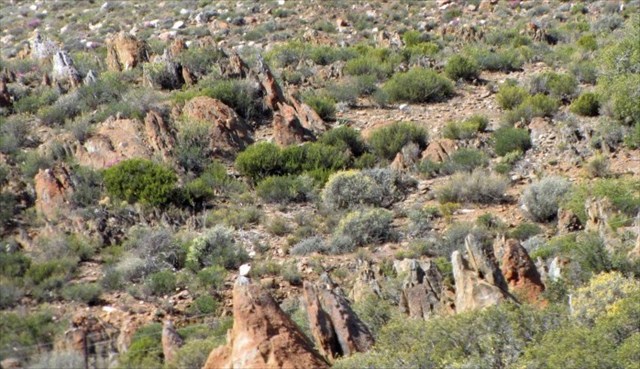 |
| Tombstone shaped rock |
![]() This lithological horizon is an indicator horizon, which separates the Cape Supergroup rocks to the south and the Karoo Supergroup rocks to the north. Dwyka Group rocks are fairly easy to spot in the veld, as they weather to form an irregular landscape that looks like tombstones – so called “tombstone weathering”.
This lithological horizon is an indicator horizon, which separates the Cape Supergroup rocks to the south and the Karoo Supergroup rocks to the north. Dwyka Group rocks are fairly easy to spot in the veld, as they weather to form an irregular landscape that looks like tombstones – so called “tombstone weathering”.
The next formations are rocks of the Witteberg Group, part of the Cape Supergroup which comprise quartzitic sandstone, sandstone and shale and were deposited about 400 mya during the Devonian Period. These rock types make up the Zuurberg mountain range.
Also to the south of the Zuurberg mountains are rocks of the Suurberg group. These are extrusive (igneous rocks that flow across the surface) rocks derived from great depth and associated with volcanic activity due to crustal tectonics during the break up of Gondwana. These comprise basalt, tuff, and breccia.
During the Jurassic Period (about 140 to 190 mya) torrential streams eroded the quartzitic sandstone highlands and deposited extensive boulder beds and gravels. The resultant red coloured conglomeritic Enon Formation (named after the small village of Enon to the north of Port Elizabeth) is a very prominent horizon along the southern foothills of the Zuurberg Mountain range.
After flowing through the Zuurberg Mountains the Sundays River enters the Algoa Basin and flows through deposits of the Uitenhage group.
The Mesozoic Algoa Basin represents a very significant geological event along the south-eastern coast of southern Africa. The Algoa Basin extends along the Algoa Bay coastline from Bethelsdorp in the south-west to the Sundays River mouth in the north-east. It probably extends even further beneath the surface cover material to the Woody Cape cliffs area. It extends inland along what is called a “panhandle” to the Erekroonspoort area, about 25 km east of Jansenville.
The Kirkwood Formation sedimentation began towards the end of the Jurassic Period (about 140 to 150 mya). The Kirkwood Formation represents an accumulation of fine-grained sediments under fluvial conditions. The resultant mudstone and subordinate sandstone also contains foliage and wood fossils. The fluvial deposition began to fill the Algoa Basin and was followed by marine ingression to form the Sundays River Formation. This Formation contains numerous marine fossils, such as ammonites, belemnites, bivalves and gastropods (shells). From oldest to youngest, the Enon, Kirkwood and Sundays River Formations are collectively referred to as the Uitenhage Group.
 |
| Algoa Group |
The final formation along the river before the dune fields at the mouth is the Algoa Group.
By the end of the Cretaceous Period (about 80 mya), the present configuration of the Southern African coastline was established. The evolution of the landscape from this time onwards was dictated to a large extent by fluctuating sea-levels. Climatic cooling results in more seawater freezing in the Polar Regions, which will correspond with a dropping of global sea level. By the same token, sea level rise will be associated with global warming.
These fluctuations in sea levels have resulted in a number of fairly level wave-cut platforms. These levels occur in about three different heights (each representing a different sea level), each formed during a still-stand followed by further lowering of sea level.
The most recent of all geological formations is the aeolian Schelm Hoek Formation. This comprises windblown sand adjacent to the present day coastline and is still being deposited. The Schelm Hoek Formation includes the Alexandria dune sea east of the river mouth. This formation includes an older generation vegetated dune and a younger generation, non-vegetated sand dune. The migration of the latter has been retarded to a certain extent by the infestation of Australian wattle species, especially noticeable along the eastern side of the Sundays River mouth.
Estuary
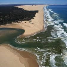 The extensive Sundays River estuary has a length of approximately 20 km and a surface area of 3 sq. km.
The estuary has a regular pattern of freshwater input, leading to a dilution of its natural saline regime. Recreation (sailing, fishing) is the main activity on the estuary, with limited farming practised in the flood plain. There are no industrial activities, and very low human habitation along the river and estuary. It is thus a relatively “pristine” estuary, although elevated levels of N and P have been measured from time to time due to agricultural practices within the catchment area.
References:
Biodiversity Sector Plan for the Sundays River Valley Municipality 2012 - D.C Vromans, K.S. Maree, S.D. Holness and A.L. Skowno
Wikipedia
Sundays River Estuary, Algoa Bay, Eastern Cape, South Africa Dan Baird
South African National Parks
The Relation between South African Geology and Geohydrology - Paul Joël Havemann Lourens
Geological Journeys – Nick Norman and Gavin Whitfield. ISBN 978-1-77007-062-2
Department of National Geo-spatial Information