Restinga do Lobito EarthCache
-
Difficulty:
-

-
Terrain:
-
Size:  (other)
Please note Use of geocaching.com services is subject to the terms and conditions
in our disclaimer.
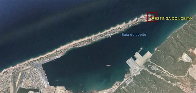
RESTINGA DO LOBITO
[EN] The Earth's surface is the result of a balance between the planet's internal forces, that create volcanoes, mountain ranges and depressions and move the rigid chuncks of the crust around (the tectonic plates) and the never ending effects of the external atmospheric elements and the rivers and oceans (basically air and water, liquid or solid) . Internal forces create topographic features, irregularities, and air and water (with the help of the long geological time) smooth them out. Where there is a hill, there's material moving to fill a valley.
The Angolan geology has unique features. Diamonds, oil and gas, phosphates and gold, iron and pegmatitic minerals abound. Its economy has been based on oil and diamonds for the past three decades. Diamond deposits, for example, are a direct result of the balance between these conflicting geological forces. Diamonds are carried to the surface (from the Earth's interior, where they are fomred, 200 km deep or more) by special volcanic phenomena, kimberlite and lamproite, in special tectonic settings. Being of deep origin, the kimberlite (s.l.) rocks quickly rot and its residues are quickly washed away by moving water. Among those residues, diamonds (the hardest substance) literally shine (resisting to transport distances of hundreds or thousands of km). During their travel through river systems, diamonds carried to the surface by volcanic eruptions, eventually concentrate and deposit, forming the renowned Angolan alluvial deposits.
One other unique feature of Angola, perhaps its greatest richness (not oil) is the fact it has abundant water resouces. The Kwanza (Cuanza) River is a major Angolan water course. Yes, it crosses kimberlite provinces; yes, it carries diamonds and deposits them in its margins (today and in past). But like the Kwanza River, the Catumbela River, also nourishes agricultural lands and wild ecosystems and generates part of the electrical power that lights the Angolan population. The Catumbela River also carries commnon, humble, sediments: sand and clay minerals. Part of those sediments is carried to the sea (the Angolan hinterlands filling the Atlanctic depression). Where the Catumbela River meets the ocean, south of Lobito, its sediments meet the cold, fish rich, Benguela current. These sediments are carried northward by the Benguela current along the coast (with splendorous beaches as a striking testimony). In certain areas, controlled by local conditions, Restingas (large coastal sand bars) are formed.
Lobito, in Benguela province, has a striking example of a Restinga (as other Angolan coast points like "Restinga de Luanda"). This Earthcache celebrates restingas' beauty, their importance as the ecosystems, the complex Earth process that generates them and, yes, the nice spots that allow us to relax at the sun, next to the sea water and, preferably, with a fresh drink and a good friends company. Yes, this describes the "Restinga de Lobito", my favorite Restinga in Angola... my favorite Restinga in the world.

3) Optionally, taking a foto (selfie) at the GZ were i can see the Lobito Restinga Lighthouse. (Not obligatory).
Send me your answers to my profile e-mail, not by profile message, so I can validate your log.
[PT] A EarthCache
Para considerar um "found" desta earthcache, devem cumprir estes três objectivos:
1) Qual a dimensão da granulometria da areia no Ponto Zero? (<1mm ; > 1mm e < 2mm ; >2mm).
2) Qual o papel dos pontões de pedra ao longo de toda a restinga?
3) Como opção, tirem uma foto vossa (selfie) no Ponto Zero onde se possa observar o Farol da Restinfa do Lobito. (Não obrigatório).
Enviem-me as resposta para o meu e-mail de perfil, nunca para as mensagens do perfil, para que possa validar o vosso found.

Additional Hints
(No hints available.)