The Iguazu Falls
The Iguazu Falls are one of the greatest natural wonders of the world.Iguass Falls were discovered for Europeans by the Spanish Alvar Nunez Cabeza de Vaca in 1542, who named it Saltos de Santa Maria, but very soon after regained its original name guarani Iguazu. The waterfall system consists of 275 falls that are up to 80 meters high. The "large water" or Iguaçu in the language of the Tupi, have formed before about 200 million years ago in the division of South America from the African continent. As the continents have drifted apart, the several geological changes in the American continent meant. Ago between 1.5 and 1 million years, the river Parana mightiest resulted in a first slope, a result of their greater erosive capacity, which would be the embryo of the falls. Since then, remontant erosion has caused cataracts traveling over 23 km upstream from the confluence of the Parana River Falls to their current situation. As witness this backward motion is the canyon of the Falls: it is remarkable the contrast between the shape of the river before the falls, with a broad, meandering channel (reaching 1,500 meters wide just before the falls), and its place in a canyon between cataracts and his meeting with the Parana.
Potholes- How did they come?
Here at the Iguazu waterfalls are found in the main magmatic rocks. Various basalt rocks such as Dolerit and Melaphyr form the bedrock. Because the ness of the rocks are different, that potholes can arise here in the interplay of water and stones. Potholes we can discover in the bed or shore area of rivers. They have a cylindrical and barrel-shaped appearance. They are formed by a fluvial erosion. Originally they are caused when water rolls move in rotation on one point. By permanently increased velocity of the water is not only a reinforced material transport, but also swirling cobbles support the erosion and abrasion processes. Under erosion we understand the natural erosion of rocks and soil by water, glaciers and wind. In contrast, abrasion describes the mechanical grinding of hard rocks. Visible signs of grinding the rock are polishes and potholes. We call this process as Evorsion. It is the undermining effect of swirling rocks and sand in water. By Evorsion arise in the riverbed, even in hard rock, especially below waterfalls these potholes. The water carries sand and gravel with it and is brought to swirls through unevenness and obstacles of the walls and the bottom.
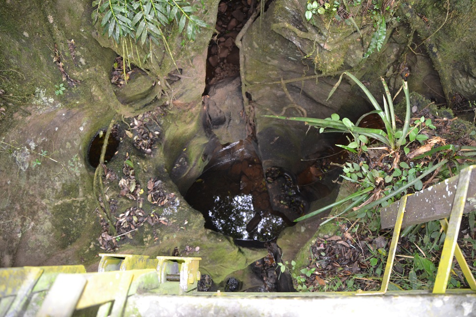 Good condition, conspicuous and clearly visible are potholes on flat rock slabs. At this location, have formed very striking potholes. The graphics describe clearly their development process. First formed in the body of water a slight depression. By swirling the water further erosion takes place. Over time, collects in the basin harder rocks that can’t get out and the hole can be deeper. After and after, these stones are usually cut himself quite round.
I would be very happy for a picture of you at this location. But this is of course not mandatory. To log this cache, go to this location and answer the following questions. Then post a photo of you at the location to your log. Of course, if you do not want to appear in the photo, a personal item in the photo is enough proof of your presence. (According to the Earthcache Guidelines, photo-proofing has been required since June 2019.) After that you can give your log directly. If anything is not ok, we will contact you.
1.) At the cache coordinates you'll find right next to the walkway in about 5m depth a large pothole (see Spoiler 1). Treasures its depth and width.
2.) Describe its shape. Can you detect a structure on the inner wall, or is it here to a homogeneous rock structure?
3.) WP2: If you are on the way to the platform, you'll find at these coordinates right next to the jetty several round stones. (See Spoiler 2) Look at them closely. Could they be responsible for a pothole? Explain your answer.

Die Iguazu Wasserfälle
Die Iguazu Wasserfälle sind eines der größten Naturwunder der Welt. Die Wasserfälle wurden für die Europäer vom dem Spanier Alvar Nunez Cabeza de Vaca in 1542 entdeckt. Er benannte sie Saltos de Santa Maria, aber sehr bald danach erhielten sie wieder ihren ursprünglichen Namen Iguazu. Das Wasserfallsystem besteht aus 275 Fällen, die bis zu 70 Meter hoch sind. Das „große Wasser“ oder Iguaçu in der Sprache der Tupi, haben sich vor ca. 200 Millionen Jahren bei der Teilung Südamerikas vom afrikanischen Kontinent gebildet. Als die Kontinente auseinander gedriftet sind, hatte das mehrere geologische Veränderungen auf dem amerikanischen Kontinent zur Folge. Vor zwischen 1,5 und 1 Million Jahren führte der Fluss Parana zu einem ersten mächtigem Gefälle, ein Ergebnis seiner großen erosiven Macht, das der Embryo der Wasserfälle war. Seitdem hat die Erosion eine rückwärtige Bewegung des Wasserfalls von über 23 km verursacht, stromaufwärts von der Mündung des Parana River Falls zu ihrer aktuellen Lage. Ein Zeugnis dieser Rückwärtsbewegung ist die Schlucht des Falls: Bemerkenswert ist der Kontrast zwischen der Form des Flusses vor den Wasserfällen , mit einem breiten, mäandrierenden Kanal ( Er erreicht eine Breite von 1500 Meter kurz vor den Wasserfällen ), seinem Platz in einer Schlucht zwischen den Wasserfällen und seinem Treffen mit dem Parana.
Strudeltöpfe– Wie sind sie entstanden?
Hier an den Iguazu-Wasserfällen finden wir in der Hauptsache magmatische Gesteine.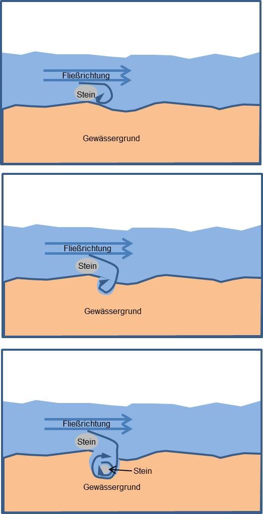 Verschiedene Basaltgesteine, wie Melaphyr und Dolerit bilden die Grundgesteine. Da sie unterschiedlich hart sind, können hier im Zusammenspiel von Wasser und Steine die Strudeltöpfe entstehen. Strudeltöpfe finden wir im Bett oder Uferbereich von Flüssen. Sie haben ein zylindrisches bis wannenförmiges Aussehen. Bei ihrer Entstehung handelt es sich um eine fluviale Erosion. Ursprünglich werden sie verursacht, wenn Wasserwalzen sich rotierend auf einer Stelle bewegen. Durch die permanent erhöhte Geschwindigkeit des Wassers erfolgt hier nicht nur ein verstärkter Materialtransport, sondern auch herumwirbelnde Gerölle unterstützen die Erosions- und Abrasionsprozesse. Unter Erosion verstehen wir die natürliche Abtragung von Gestein und Boden durch Wasser, Gletscher und Wind. Im Gegensatz dazu beschreibt die Abrasion das mechanische Abschleifen von Festgesteinen. Sichtbare Zeichen des Abschleifens am Gestein sind Polituren und Strudellöcher. Diesen Vorgang bezeichnen wir als Evorsion. Es ist die aushöhlende Wirkung von im Wasser wirbelnden Steinen und Sandkörnern. Durch die Evorsion entstehen im Flussbett, auch im Festgestein, besonders unterhalb von Wasserfällen diese Strudellöcher. Das Wasser führt Sand und Geröll mit sich und wird durch Unebenheiten und Hindernisse der Wände und des Bodens zum Strudeln gebracht.Gut erhalten, auffällig und gut sichtbar sind Strudeltöpfe auf ebenen Felsplatten. An dieser Stelle haben sich nun sehr markante Strudeltöpfe gebildet. Die Grafiken beschreiben sehr deutlich ihren Entstehungsprozess. Zuerst bildet sich am Gewässergrund eine leichte Vertiefung. Durch das Verwirbeln des Wassers findet eine weitere Erosion statt. Im Laufe der Zeit sammelt sich in dem Becken härteres Gestein, dass nicht mehr herauskommt und das Loch immer tiefer werden lässt. Dabei werden diese Steine meistens selber recht rund geschliffen.
Um diesen Cache zu loggen, begib dich zu dieser Location und beantworte nachfolgende Fragen. Anschließend postet zu eurem Log bitte noch ein Foto von euch an der Location. Wenn ihr selbst nicht auf dem Foto erscheinen wollt, reicht natürlich auch ein persönlicher Gegenstand auf dem Foto als Beweis eurer Anwesenheit. (Laut Earthcache Guidelines ist die Forderung eines Fotobeweises seit Juni 2019 wieder erlaubt.)
Danach könnt Ihr sofort loggen. Wenn irgendetwas nicht in Ordnung sein sollte, melde ich mich.
1.) An den Cachekoordinaten findest du direkt neben dem Steg in ca. 5m Tiefe einen großen Strudeltopf ( siehe Spoiler 1 ). Schätze seine Tiefe und Breite.
2.) Beschreibe seine Form. Kann man eine Struktur an der Innenwand erkennen, oder handelt es sich hier um eine homogene Gesteinsstruktur?
3.) WP2: Wenn du auf dem Weg zur Plattform bist, findest du an diesen Koordinaten rechts neben dem Steg mehrere runde Steine. ( siehe Spoiler 2) Schaue sie dir genau an. Könnten sie für ein Strudeltopf verantwortlich sein? Begründe deine Antwort.
source directory:
-Wikipedia
-Mineralienatlas.de
-spektrum.de/lexikon/geographie
-Picture by my own
-Graphics: by my own