The Cache
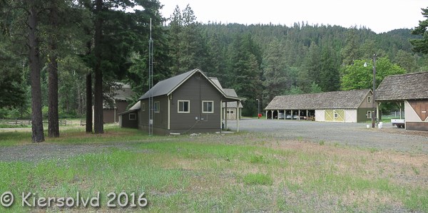
The posted coordinates are for a pullout along Hwy 410. It is very near the cache's actual location, perhaps within sight, where there is ample parking.
At the pullout, you'll find a brass plaque commemorating this location as a Civilian Conservation Corp (CCC) camp. You need to find certain numbers on the plaque and use them to obtain the coordinates for the cache itself.
Cache coordinates: N 46° 54.ABC W 121° 01.J[K+L][M+N]
- Year the camp opened: AxKL
- Year the camp closed: xxCx
- Camp number: Co. xMN-FBJ
Location
The Chinook Pass Work Station is located on both sides of the highway, with the work buildings on the south side and the residences on the north side. It was the Naches Ranger Station of the US Forest Service until 1981, when the district merged with the Teiton District and this facility became a work station. A now-archived cache had been located at this pullout but was removed at the request of the station manager.
History
The Naches Ranger District, established circa 1900, encompassed lands within the Naches River drainage. In 1904 the first administrative headquarters was located at the Nile Creek Guard Station under the administration of first District Ranger W.W. Cryder. In 1910 the District headquarters was transferred to the Little Fish Ranger Station, constructed on Nile Creek by District Ranger Harry Croxford. By 1919-20 the guard station at Currant Flat on the Naches River had become the administrative headquarters of the Naches District. E.K. Currant, a Summit District miner, had previously located a cabin at that location.
Currant Flat was actually one-half mile upstream from where the Naches Ranger Station was finally established at Anderson Flat. When the Forest Service failed to obtain Currant's homestead for the location of their new station, they chose Anderson Flat, the early homestead of Charles Anderson and later John Emerick, for their new station and called it Currant Flat Ranger Station. The land had been deeded to the federal government by the Northern Pacific Railroad in 1899, and was withdrawn from the public domain for forest service use in 1906. The station's location was chosen for its extensive pasturage, close proximity to the Forest boundary, and sitting on a major cross-Cascade route, State Highway 410. A permanent route over Naches Pass, however, never materialized. Instead, a route over Chinook Pass was completed in 1929 because it afforded convenient access to Mt. Rainier National Park. In 1931 the route was dedicated the Mather Memorial Highway after Stephen T. Mather, the first director of the National Park Service. The highway included a one-half mile protected scenic zone on both sides of the road, from the east boundary of Rainier National Forest to the west boundary near Greenwater.
Construction of the Naches Ranger Station at Currant Flat began circa 1921, under the supervision of District Ranger Henry Croxford. The station was the administrative center of the Naches Ranger District until the consolidation with the Tieton District in 1981, when a new office was established in the town of Naches. The former Ranger station today serves as the Chinook Pass Work Center.
America was in the grip of the Great Depression when Franklin Delano Roosevelt was inaugurated in March of 1933. More than twenty-five percent of the population was unemployed, hungry and without hope. The New Deal programs instituted bold changes in the federal government that energized the economy and created an equilibrium that helped to bolster the needs of citizens. Out of the economic chaos emerged the Civilian Conservation Corps (CCC). The goal was two-fold: conservation of our natural resources and the salvage of our young men. The CCC is recognized as the single greatest conservation program in America and it served as a catalyst to develop the very tenets of modern conservation. The work of America's young men dramatically changed the future and today we still enjoy a legacy of natural resource treasures that dot the American landscape
The CCC influenced the physical development of the U.S. Forest Service more than any other single group or federal program. While several federal agencies utilized the manpower of the CCC, the Forest Service was one of its first and most enthusiastic supporters. The CCC had a significant impact on the development and improvement of the National Forests in the Pacific Northwest; reforestation projects, soil erosion control, and construction of trails, roads, fire lookouts and ranger station facilities were undertaken by the CCC.
The construction of Region 6 rustic-style buildings at the Naches Ranger Station by the CCC reflected a national policy that promoted expansion of Forest Service facilities and responsibilities during the Depression period. In 1932, the Forest Service initiated an extensive ten-year national plan for forest projects and resource development which marked a major shift of emphasis from earlier custodial responsibilities. The establishment of the CCC coincided with the implementation of this plan and Forest Service CCC camps were rapidly established between 1933-1935.
Enrollees into the CCC were mobilized and trained by the U.S. Army, while federal agencies such as the Forest Service provided the work opportunities. Each Army district had numerous camps and "side" camps. Camp Naches, the 932nd Company of the Fort Lewis District, was established at Nile Creek in May 1933. After six months the camp was transferred to Cherry Valley near Seattle. In April 1934 the company moved back to the Naches Valley and began construction of the final Camp Naches (F-70) at Currant Flat (Naches) Ranger Station.
Camp Naches was located in the open pasturage on the station's south side between to the state highway. At its peak the camp had upwards to 250 men . Today there are no visible remains of the camp, which included recreation and mess halls, crew quarters, a ball field and a swimming pool. Camp Naches was one of the largest camps in the Fort Lewis District, certainly the most significant in the Yakima-Naches region. Camp Tieton was the next largest camp. Smaller side camps existed at Clear Lake, Bumping Lake, Pleasant Valley, and Huckleberry Mountain.
The CCC at Camp Naches engaged in intensive construction activities: building fire lookouts, bridges, trails, roads and campgrounds. At the Naches Ranger Station itself twelve buildings were constructed by the CCC. Local carpenters were reportedly hired out of Yakima to work with the CCC work force on construction of these buildings. Civilians often worked with the CCC labor force, for much of the supervisory personnel of the CCC was civilian. Physical evidence of the CCC contributions is visible throughout the Wenatchee and Snoqualmie National Forests. Almost every type of recreational activity that takes place today from Naches Station to the Cascade crest makes use of facilities constructed by Camp Naches CCC members.
References
- Historical Building Survey
- CCC Legacy
2016 was the 100th anniversary of the National Park Service, and to celebrate, Visit Rainier and WSGA hosted the Visit Rainier Centennial GeoTour - 100 caches placed in and around Mount Rainier National Park. The geocaches highlighted the rich history, scenic wonders, quaint communities, and hidden gems of the Rainier region. Participants received geocoin and pathtag prizes for finding all the caches.

