General Information and Warnings
Here at Cwmorthin you will find a stunning glacial valley but geologically it can be confusing due to the vast amounts of slate mining and surface quarrying that have taken place here. The earthcaches on this trail focus on both the original glacial features of the valley, and also the interesting slate that has been exposed from underground by the workings. Always remember that the huge piles of slate you will frequently walk over and past were not placed here naturally, this is all the work of man. As you walk around, try and keep an image in your mind of how the valley would have looked before the slate was quarried.
Our earthcache trail keeps to the tracks around the old quarry and mine areas. The mines are extensive and the main adit should all be gated and locked. Some mines were abandoned because they were too unsafe to work. It is not recommended to climb the spoil heaps or explore away from the paths as there could be hidden dangers, and it’s not recommended to let children or pets run off unsupervised. Also be aware that slate can have a very sharp edge and can cut very deeply, so please treat this area with the respect it requires.
Information about the Waterfall
The first earthcache on the Cwmorthin Geology Trail brings you to a very picturesque waterfall at the entrance to the Cwmorthin Valley. First we need to think about how this waterfall fits in with the valley around it. Valleys are formed in several ways. When they are formed by a river, the valley entrance/exit is often at the same level as the land outside the valley, but when the valley was formed by a glacier, it means a huge block of ice carved out the valley during one of the ice ages. This block of ice may have left the entrance/exit to the valley at a higher level than the land outside of valley, meaning you have to climb up into the valley, and this is why the next bit of your walk will be up hill! It also means the water that is flowing out of the valley today has to drop down to reach the land outside the valley, and part of that drop is happening in front of you here.
Generally speaking, when a waterfall forms closer to the source of the river, the river course takes it over resistant bedrock and erosion happens slowly, while downstream the erosion occurs more rapidly. Streams become wider and shallower just above waterfalls due to flowing over the rock shelf, and there is usually a deep area just below the waterfall because of the force of the water hitting the bottom. Waterfalls normally form in a rocky area due to erosion. After a long period of being fully formed, the water falling off the ledge will retreat, causing a horizontal pit parallel to the waterfall wall. Eventually, as the pit grows deeper, the waterfall collapses to be replaced by a steeply sloping stretch of river bed. A river sometimes flows over a large step in the rocks that may have been formed by a fault line. Waterfalls can occur along the edge of a glacial trough, where a stream or river flowing into a glacier continues to flow into a valley after the glacier has receded or melted. This can be referred to as a hanging valley.
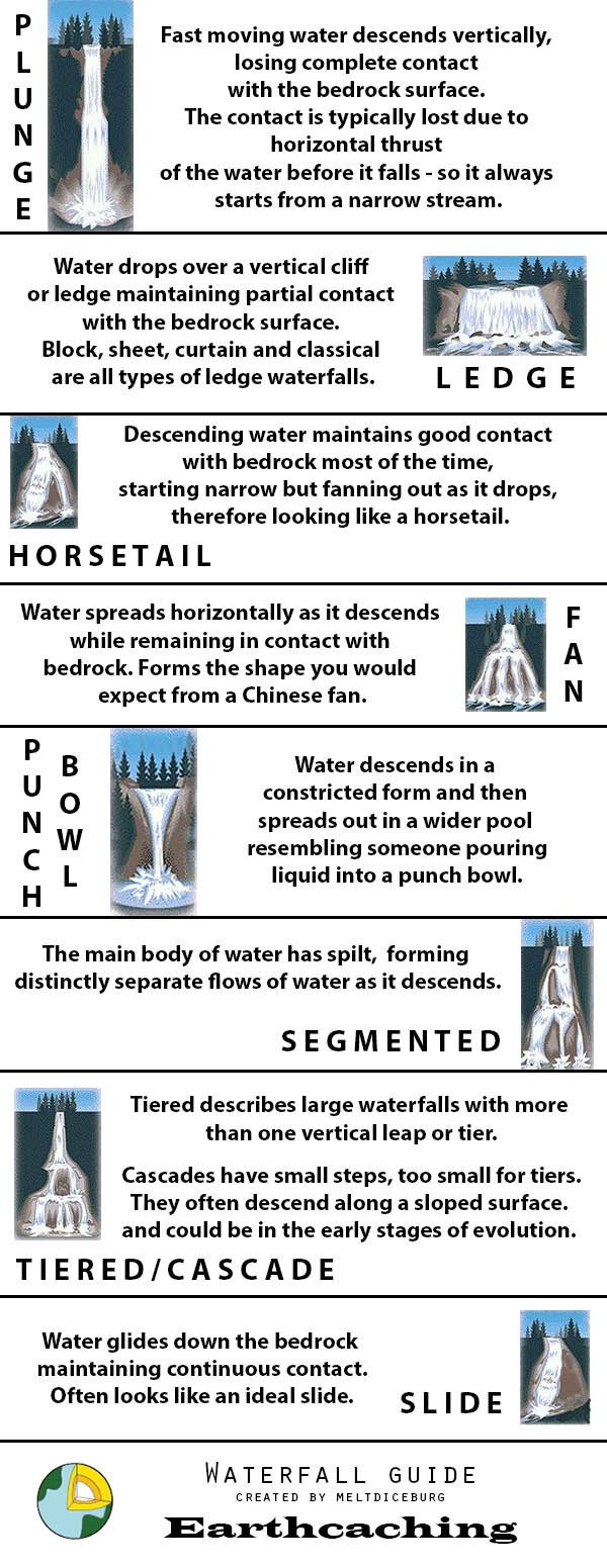
There are different types of waterfall and these are shown above on the diagram. You will need to print the diagram, or view it on your smart phone. If you find you can’t view the diagram at GZ, please take a photo so you can identify the waterfall type later.
Logging Requirements (Questions to Answer)
Please e-mail me the answers to the below questions via my profile. I do read all answers and try to reply to them all; I may not reply immediately so please do not wait for a reply before posting your find. Ideally, please send your answers at the same time you submit your log, or within a few days of your visit. I do check answers have been sent for every log, if you do not send answers within a week your log may be deleted. You are not expected to have any previous geological knowledge, your best attempt at the answers is all that is required.
1. From the waterfall illustration above, can you identify the type of waterfall here? Why do you think it is this type?
2. Facing the waterfall at the given co-ordinates, please describe the rock face to the left of the waterfall, and then describe the rock to the right of the waterfall.
3. Given your answer to the previous question, why do you think the waterfall has chosen this path?
We always like to see photographs of you and/or your GPS device with the geological features - plus this also provides additional proof of your visit, so please include one with your log if you wish.
This cache has been produced especially for the