Grand Etang Crater Lake, Grenada EarthCache
Grand Etang Crater Lake, Grenada
-
Difficulty:
-

-
Terrain:
-

Size:  (other)
Please note Use of geocaching.com services is subject to the terms and conditions
in our disclaimer.

Please do not log a find on this cache until you have sent the answers. The busy cruising season makes it too hard to keep track. Just post a note as a placeholder in the meantime. Logs with no answers will be deleted. Apologies, but I will no longer message cachers who do not send answers with their logs.
Hello and welcome to the Grand Etang! This is an Earthcache. There is no physical container to find. Logging an Earthcache requires that visitors undertake an educational task relating to the specific Earth Science at the site. To earn credit for this Earthcache you must answer a series of questions posed on this cache page.
Welcome to the Grand Etang Rain Forest Reserve and National Park! The Grand Etang Forest Reserve was established in 1906 and covers an area of 3816 acres. Within the protected rain forest reserve lies the source of the largest river on the island, the Great River, which drains into the Atlantic ocean on the eastern side of the island. The Seven Sisters waterfall is on one of the many tributaries flowing from this watershed area. The reserve is also home to four of Grenada's highest mountains including the Southeast Mountain (712m), Mount Sinai (700m), Mount Qua Qua (713m) and an unnamed peak measuring 760m in height.
One of the key features of the reserve (and the focus of this earth cache) is the famous Grand Etang Crater Lake. The lake was formed by volcanic activity that took place some 12,000 - 25,000 years ago. The lake is 1740 feet above sea level and measures 36 acres. But exactly what is a crater lake and how did it get there? Before we can answer that question let's go back for a brief summation of the geologic history of the area.
Grenada is the most southerly of the Windward Islands and is part of the volcanic chain in the Lesser Antilles Arc. Grenada lies on the eastern portion of the Caribbean tectonic plate.

The gigantic plates of the earth's surface meet in the Caribbean. The enormous forces of mainly the Caribbean, North American and South American plates moving and grinding against one another generate enormous pressure which is periodically released in earthquakes or volcanoes. As these volcanic eruptions continue over eons, islands are built up from the deposits of lava and ash. The inner arc of the Lesser Antilles rose up out of the sea some 30 million years ago.
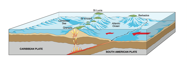
The Grand Etang Crater Lake is part of the Mount St Catherine 'massif' (which is defined as a compact group of connected mountains forming an independent portion of a larger range). The Mt. St. Catherine massif represents some of the younger major volcanic structures on the island. The final stage of volcanic activity caused the formation of explosion craters throughout Grenada, most notably the Grand Etang, along with Lake Antoine and St George's. The three closely-spaced explosion craters at Grand Etang are generally thought to be the youngest volcanic structures on the island having formed approximately 12,000 years ago.
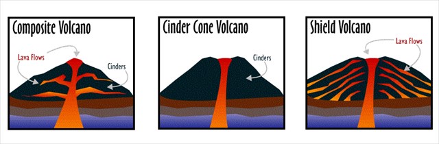
Out of the three main types of volcanoes known as stratovolcano/composite, cinder cone or shield, the Grand Etang Crater lake was formed by a volcano type called 'stratovolcano' or 'composite' volcano. Stratovolcanoes are what most people associate with the word 'volcano'. These towering peaks rise hundreds to several thousands of meters above their surroundings, often visually dominating the landscape around them. As their name implies, they are formed of stratified layers of both viscous lava flows and fragmental material. Most stratovolcanoes are complex structures formed by multiple eruptions from summit and flank vents. Some stratovolcanoes may form in a few thousand years, but may remain active for tens to hundreds of thousands of years.
When volcanic craters cool down after major eruptions, they sometimes fill with water to form 'crater lakes'. The water may come from precipitation, groundwater circulation or melted ice. The water level rises until an equilibrium is reached between the rates of incoming and outgoing water. Reasons for water loss within the lake may include evaporation, subsurface seepage or surface leakage or overflow when the lake level reaches the lowest point on its rim. Water temperature in a crater lake varies. Some crater lakes are cool when they are just filled by rain water or melted ice, and others are warm or even hot when they are still connected to their volcanic plumbing. The waters of the Grand Etang are relatively cool as the volcano is considered long dormant. Below is a graphic view of crater lake formation as the crater slowly cools after the eruption cycle.

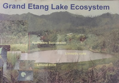
Today Grand Etang Crater Lake is part of a diverse ecosystem and is an integral part of the rain forest preserve and its beauty today resembles nothing of its violent fiery beginning. The lake is rich in plant and animal life. The lake itself can be devided into two distinct zones: the 'littoral zone' and the 'limnetic zone'.
The shallow waters together along with the vegetation make up the littoral zone of the lake. Most of the organisms live within this zone because it is the most productive, containing food trapped from the land as well as that produced in the lake. The root system of trees provides surfaces for organisms to live on and also provides protection from larger predators. The open water is known as the limnetic zone. Large species tend to occupy that zone although they also use the littoral zone to feed and reproduce. Several species are bottom dwellers or benthic, living on the floor of the lake and within the sediment.
*Update June 15, 2019: A photo can now be required as a logging condition of an earth cache! To earn credit for this Earthcache you must visit the Grand Etang National Park and answer the following questions. All answers can be found in the visitors center. I realize that many visitors will be on vacation and will have limited internet from which to log. But if you have connectivity to log, you should also be able to email to me your answers. Please don't give me the unfortunate duty of deleting logs that are not accompanied by the required information. Thank you in advance for your understanding and I hope you enjoy learning about the Grand Etang Crater Lake!IMPORTANT!!!!! If you are sending answers for more than one person, you MUST include all the names in your group in your email! Please understand that I will no longer try and figure out who is caching together and will delete logs that are not named in group emails.
1. Grand Etang Crater Lake is filled mainly by rainfall. According to the signage, how many inches of rain per year falls in the Preserve?
2. What is an ecotone?
3. Why is it difficult to determine the exact waters edge of the lake?
4. What is the definition of 'hydrosere succession'?
5. REQUIRED: Please post a photo of yourself or your GPS showing your location at the Crater Lake overlook showing the lake in the background or in front of the Welcome Center.

Sources: www.volcano.si.edu www.geonet.org.nz www.nationalgeographic.com www.geology.com www.macmillan-caribbean.com www.geology.sdsu.edu.com
Additional Hints
(Decrypt)
Nafjref pna or sbhaq va gur ivfvgbef pragre