 LES RUINES DE SECHILIENNE
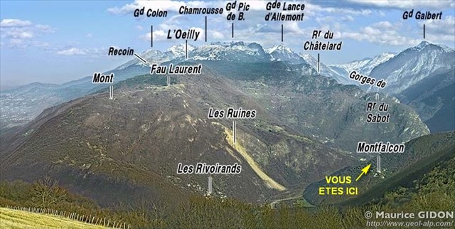
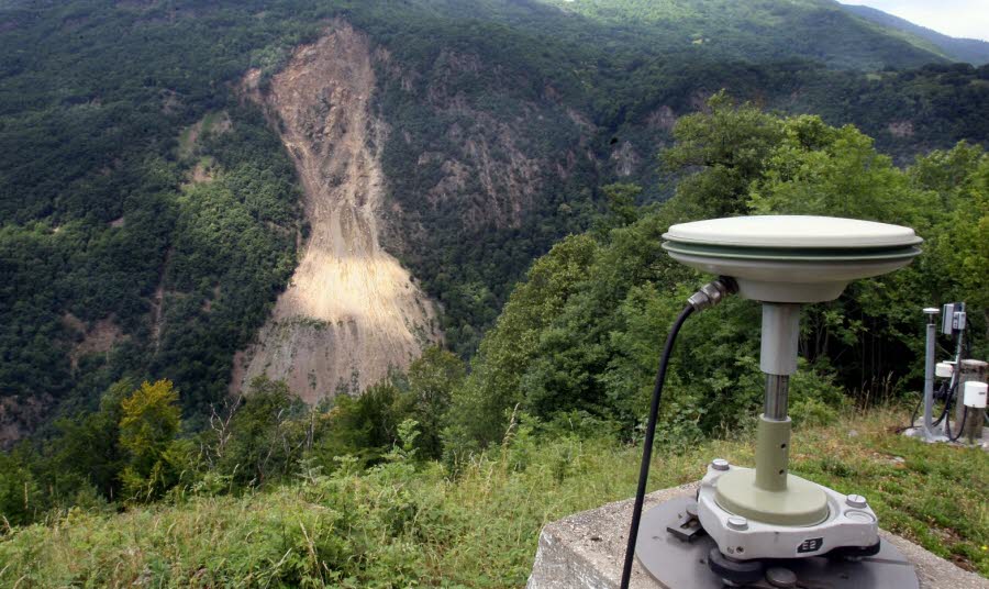 Au Sud du massif de Belledonne, des fractures et des affaissements affectent les terrains du versant Sud de la montagne au lieu appelé les Ruines de Séchilienne.
L'aléa est bien connu et des éboulements mineurs ont régulièrement lieu. Le cône d’éboulis évolue d’année en année, et est bien surveillé. Des réflecteurs laser sont positionnés au niveau du décollement supérieur, la mesure régulière de leurs positions absolues et relatives permet un suivi des mouvements de ce flanc de montagne. On peut ainsi enregistrer "en routine" le très lent glissement vers le bas, et, éventuellement, noter une accélération de cette vitesse, annonciatrice d’un possible éboulement majeur.
Le risque majeur, dans le cas présent, est un éboulement important et brutal qui obstruerait la vallée étroite de la .... (environ 400 m de largeur à hauteur de la route actuelle, face au cône d'éboulis). Un tel événement créerait une retenue d'eau qui ennoierait l'amont (Séchilienne) dans un premier temps avant que la pression ne rompe le barrage d'éboulis et ne provoque une vague qui inonderait l'aval (Vizille...).
 La catastrophe de référence due à la rupture d'un barrage de ce type est l'inondation de Grenoble de 1219. En août 1191 un glissement de terrain barra la ..... au niveau des gorges de l'Infernet, créant un lac en amont, appelé lac Saint Laurent. La rupture de ce barrage suite à de violents orages en septembre 1219 entraîna la vidange du lac et le déferlement d'une vague qui descendit la Romanche puis le Drac avant d'atteindre l'Isère et Grenoble. Cette vague bloqua le flux naturel des rivières, créant des accumulation d'eau temporaires en amont de Grenoble dont la vidange, dans un second temps, provoqua les dégâts les plus importants.
Un suivi permanent des mouvements de terrain et un protocole d'alerte existent pour éviter la répétition d'une catastrophe suivant un scénario semblable à celui de 1219.
QUESTIONS
 "Loguez cette cache "Found it" et envoyez-moi immédiatement vos propositions de réponses soit via mon profil, soit via la messagerie geocaching.com (Message Center), et je vous contacterai en cas de problème." Il est inutile de pénétrer sur le site pour répondre aux questions.
1 - Quel est le nom de la rivière qui coule en fond de vallée ?
2 - Placez vous face aux ruines et déterminez de quel côté se trouve la source de la rivière, à droite ou à gauche ?
3 - Les Ruines de Séchilienne sont dominées par un sommet montagneux qui culmine à 1100 m d'altitude. Quel est le nom de ce sommet ?
4 - Plusieurs aménagements ont été mis en place pour parer des incidents de gravité croissante. Citer 3 dispositifs mis en oeuvre
5 - Estimer à 200 m près la distance qui vous sépare du sommet des ruines :
6 - Donner l'angle par rapport au Nord formé par la direction du sommet des ruines :
7 - Quel est le principal risque engendré en cas de chute des Ruines de Sichiliennes ?
8 - A quelle date (jour et mois) eut lieu la catastrophe qui inonda Grenoble en 1219 ?
9 - De quels minéraux sont composés les sols et sous-sols des Ruines ?
10 - Des dispositifs d'auscultation et de surveillance du site ont été mise en place, citer au moins 3 de ces dispositifs :
11 - Sur le portail d'accès, vous devrez trouver un numéro de téléphone, donner la somme des chiffres composant le numéro.
Une photo de votre GPS avec les ruines en fond serait très appréciée.
Bon courage, merci pour vos recherches, à bientôt
Goupil30
 RUINS OF SECHILIENNE
South of the Belledonne, fractures and subsidence affecting the grounds of the South side of the mountain instead called Séchilienne Ruins.
The hazard is well known and minor landslides take place regularly. The talus cone is changing from year to year, and is well monitored. Laser reflectors are positioned at the upper detachment, regular measurement of their absolute and relative positions allows tracking of the movements of the mountainside. We can thus save "routine" the slow slide down, and possibly note an acceleration of this speed, major harbinger of a possible landslide.
The major risk in this case is an important and brutal landslide that obstruct the narrow valley .... (approximately 400 m wide up to the current road, facing the talus cone). Such an event would create a water reservoir that ennoierait upstream (Séchilienne) initially before the pressure will break the dam of debris and causes a wave that would inundate downstream (Vizille ...).
The reference to catastrophic rupture of a dam of this type is the flood of Grenoble 1219. In August 1191 a landslide ..... the barra at the grooves Infernet, creating a lake upstream, called Lake Saint Laurent. The breaking of the dam after heavy storms in September 1219 led to the draining of the lake and the breaking of a wave that came down the Romanche and Drac before reaching the Isère and Grenoble. This wave blocked the natural flow of rivers, creating temporary accumulation of water upstream from Grenoble whose drain, in a second time, caused the most damage.
Continuous monitoring of ground movements and an alert protocol exist to avoid repetition of a disaster following a scenario similar to 1219.
QUESTIONS
"Logue this cache" Found it "immediately and send me your answers proposals either via my profile or via geocaching.com messaging (Message Center), and I will contact you in case of problems." There is no need to enter in the site to answer questions.
1 - What is the name of the river flowing in the valley ?
2 - Position yourself facing the ruins and determine which side is the source of the river, right or left ?
3 - Séchilienne Ruins are dominated by a mountain summit, at 1100 m altitude. What is the name of this summit ?
4 - Several improvements have been implemented to counter the increasing severity of incidents. Quote 3 devices used :
5 - Estimate 200 m near the distance to the top of the ruins :
6 - Give the angle to the North between the direction of the summit of the ruins :
7 - What is the main risk arising when Sichiliennes Ruins fall ?
8 - On what date (month and day) occurred the disaster that flooded Grenoble in 1219 ?
9 - What minerals are compounds floors and basements of Ruins ?
10 - Auscultation devices and site monitoring have been set up, cite at least 3 of these devices :
11 - On the access portal, you will need to find a phone number, give the sum of the digits making up the number.
A picture of your GPS with the ruins in the background would be highly appreciated.
Good luck, thank you for your research soon
Goupil30