Weir'd Trinity EarthCache
-
Difficulty:
-

-
Terrain:
-

Size:  (other)
Please note Use of geocaching.com services is subject to the terms and conditions
in our disclaimer.
Weir'd Trinity Earthcache
 Trinity River.
The Trinity River is a 710-mile-long (1,140 km) river that is the longest river that flows entirely within the U.S. state of Texas. The Trinity River has been important in shaping the Dallas Fort Worth Metroplex. The northern hemisphere ice age occurred in Pleistocene time, when a continental ice sheet reached as far south as Kansas during the Wisconsin glaciation period. The ice age climate had two effects on the Trinity River: It caused down-cutting (erosion of river bed), and a wetter climate caused much more water to flow in the river. The greater river flow generated great sedimentary terraces (deposits of glacial till). Another unique geological feature is that the Trinity is great for drinking! This is because it doesn't flow over salt-bearing Permian sediments. Consequently, the Trinity is a sweeter water.
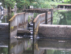
As depicted in the map, the Trinity River has four branches: the West Fork , the Clear Fork, the Elm Fork, and the East Fork. This earthcache highlights the West Fork along with it's weir features.
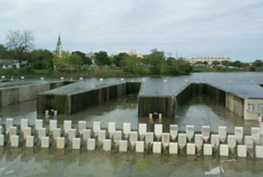
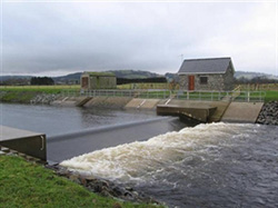
Weir.
A weir is a barrier across a river designed to alter its flow characteristics. In most cases, weirs take the form of obstructions smaller than most conventional dams, pooling water behind them while also allowing it to flow steadily over their tops. Weirs are commonly used to alter the flow of rivers to prevent flooding, measure discharge, and help render rivers navigable. A weir is anchored in the bedrock so that no water can flow under it.
Types of Weir.
| LABYRINTH WEIR: A weir with a trapezoidal shaped geometry to increase the overall weir length. They are versatile structures and can be modified to many applications. |
 |
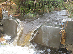 |
SHARP CRESTED WEIR: A weir with a sharp upstream corner or edge such that the water springs clear of the crest is a sharp- crested weir. Sharp-crested weirs are classified according to the shape of the weir opening, such as rectangular weirs, triangular or V-notch weirs, trapezoidal weirs, and parabolic weirs. |
| BROAD CRESTED WEIR: Broad crested weirs are robust structures that are generally constructed from reinforced concrete and which usually span the full width of the channel. They operate more effectively with higher downstream water levels than a sharp crested weir. |
 |
 |
COMPOUND WEIR: For accurate flow measurement over a wider range of flow rates, a compound weir combines two or more types - typically a V-notch weir with a rectangular weir. |
In order to log this Earthcache, you must email team wiji (see profile for email) the answers to the following questions:
1. Based on your reading above and your observations, which type best describes the weir in the Trinity river?
2. Estimate the length of the crest (the part the water flows over)? Secondly, estimate the distance between the crest and river bed below (how far the water falls)? Hint: You can estimate the length of the crest by measuring the distance across the Trinity river via the pedestrian walkway (see reference point)
3. The description above details three reasons why weirs are commonly built. Based on your observations of the area, which of these reasons do you think this weir was built for? Explain your reasoning.
4. Observe the river before and after the weir. Do you see any evidence of erosion? If so, is the erosion better or worse after the weir? Explain your reasoning.
5. OPTIONAL - Take a photo of your GPSr or yourself/team with the weir in the background. You may include this photo in your log.
++ Congratulations to TerraViators on the FTF!! ++

Additional Hints
(No hints available.)