The distinctive checkerboard pattern of land boundaries in Oklahoma and all across the West was conceived by Thomas Jefferson in the early 1780's--long before the rough and rugged character of this vast wilderness had been charted. Jefferson was the grand architect of the distinct western landscape. In the late 1800’s government surveyors were commissioned to survey the public lands for sale or grant to the public. See our geocache Correction Survey Lines (GC122YE) for more about these surveys.
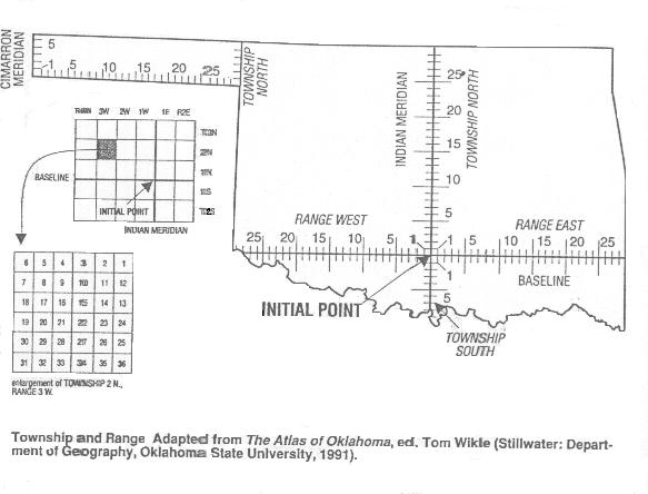
Federal land surveys in Oklahoma began in 1870, when Ehud Darling, a professional surveyor of the West, established the initial starting point for the township and range grid for Indian Territory. This point of origin is known as the INITIAL POINT. It is located on the current county line between Murray and Garvin Counties about 7 miles west of Davis, OK. A large stone monument marked “IP” still stands today in the farmer’s field. The line running east-west from this point is known as the BASE LINE and extends across the state from AR to TX. The line running north-south from this point is known as the INDIAN MERIDIAN and extends from the Red River all the way to the Kansas State Line. The actual BASE LINE is located a few hundred feet South of this cache along Beech Avenue. All public lands in Oklahoma were laid out on this grid except for the Panhandle, which was done at a later date and has its own Base Line and Meridian.
We also have a cache located along the Indian Meridian, it is called The Survey Meridian (GC122YE). If you look at the legal description of your property, it might read something like Township 2 North-Range 20 West (T2N-R20W) of the INDIAN MERIDIAN (I.M.). This means that your land is in the township located 2 North of the Base Line and 20 west of the Indian Meridian. In other words, 12 miles (2 townships x 6 miles each) North and 120 miles (20 townships x 6 miles each) West from the Initial Point. So your land is located in Jackson County near Altus. The numbering of the sections within each township was also specified by the government starting at the northeast corner with Section 1 going west and south in a serpentine manner until you reach Section 36 at the southeast corner of the township.
THE CACHE
Cache is a MICRO. This is not a difficult find but hopefully will be an educational one. Cache contains a log only so bring your own pencil.
THE OSLS GEOCACHING PROJECT
Through the Geocaching Project, The Oklahoma Society of Land Surveyors (OSLS) has established several geocaches across the state of Oklahoma. Each geocache under this project promotes three topics. The first is, of course, the geocache itself, thereby promoting the sport of geocaching, the Geocaching.com website and environmental responsibility. The second topic is the site where the geocache is placed; typically sites that relate in some way to land surveying and tell the world about it. The third topic is the promotion of surveying as a viable career choice, which is the main purpose of the OSLS Geocaching Project. A good geocache should promote all three topics. This project is an attempt to introduce geocachers to surveying and surveyors to geocaching.
Check out SurveyOklahoma.com for more information on a career in surveying.