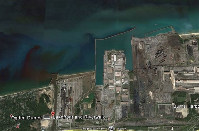
The Indiana Dunes National Lakeshore is located along 15 miles of the southern Lake Michigan shoreline and is adjacent to 2 coal fired power plants, the Port of Indiana, 3 steel mills, and 2 recreational harbors.
The various harbor and industrial facilities, involving breakwaters and other structures within the lake, have affected sand movement along the INDU beaches, with severe erosion occurring along sand-starved sections of the shoreline. Particular problem areas are at Mt. Baldy, immediately down-drift of a marina, recreation harbor, and power plant at Michigan City, and at Portage Lakefront Park, immediately down-drift of the Port of Indiana, 2 steel mills, a power plant, and a recreation harbor.
The Port of Indiana and the 2 recreation harbors are maintained by the Chicago District, U.S. Army Corps of Engineers, so the Corps is partnered with INDU on a 2-year study of the problems in 2010. For 20 years or more the Corps has been conducting beach nourishment along these 2 problem areas, but the erosion issues remain.
Biologist Elizabeth McCloskey spent a week assisting INDU and Indiana State University staff collect data about 3 current beaches and an ancient beach under a sand dune along the shoreline. This included collecting sand/sediment samples within a grid along the beach and in the lake.
INDU is using this data to determine what types of sands and perhaps gravels should be used in beach nourishment while protecting nearshore aquatic habitat. Additional aspects of the study concern the viability of the beach nourishment itself, which has not helped the situation so far, and the possibility of sand bypassing around the harbors and industries.
Beaches
Beaches are formed from locally available materials. It can be coarse or fine grained sediment. For example, boulders/rocks from cliffs, sand from rivers, and mud from rivers and waterways. Material is always in transit along the shoreline. In summertime, the waves will be different than wintertime. The waves will be lighter during the summer. However, in winter, the waves are stronger and sediment is moved away from the shore. You will notice a narrower beach.
Longshore drift, also known as littoral drift, transports the beach sediment in a zigzag fashion in the direction of the longshore current. It will occur in the surf zone.

Erosion is largely due to the natural movement of sand being obstructed by navigational harbors and shoreline structures, resulting in sand accretion (too much sand) in some areas and sand starvation (too little sand) in others. Sand dredging and artificial beach nourishment operations have been used as stop-gap measures, but this process is not sustainable and does not address the long-term problem of protecting this valuable shoreline.
The creation of ports and harbors throughout the world can seriously impact on the natural course of longshore drift. Not only do ports and harbors pose a threat to longshore drift in the short term, they also pose a threat to shoreline evolution. The major influence the creation of a port or harbor can have on longshore drift is the alteration of sedimentation patterns, which in turn may lead to accretion and/or erosion of a beach or coastal system.
What’s Happening Here
Portions of the national lakeshore, including Portage Lakefront, are particularly vulnerable to erosion from storm waves because their beaches have become narrower due to “sand-starvation.” This situation is caused by nearby harbor structures that prevent the normal cycle of sand deposition onto the beach. The national lakeshore’s Shoreline Restoration and Management Plan calls for 74,000 cubic yards of sand to be placed on the Portage Lakefront beach each year to replace what is being intercepted by the harbor structure.
During a storm in October of 2014, huge waves washed away between 75 and 115 feet of beach and dune at Indiana Dunes National Lakeshore’s Portage Lakefront and Riverwalk. In May 2015, park staff placed fencing along the remaining dunes at the site to help stabilize them and reduce the impact of future storms on that part of the lakeshore. Visitors and park neighbors were asked to help by staying out of the fenced areas so native vegetation has a chance to regrow and stabilize the dunes.
Placing sand on the beach, stabilizing the dunes is very expensive and it becomes even more critical to protecting the shoreline at Portage Lakefront. Dune grass, and other vegetation, is necessary to stabilize dunes. The fencing is designed to keep visitors from leaving the beach and designated walkways and trampling the dune’s vegetation. More than 135,000 people visited Portage Lakefront in 2014 and damage to dune vegetation is evident. Park staff counted 38 illegal trails where dune vegetation had been killed by people trampling it along a stretch of beach that is only 2/10th of a mile long. If this damage is not stabilized with dune grass, a blow-out is likely to occur placing the stability of the surrounding area at risk, including the Portage Lakefront’s pavilion and nearby private property in the Town of Ogden Dunes.
In addition to protecting property, stabilizing this area will also help protect the area’s natural resources. Despite being just over 100 acres, Portage Lakefront is home to thirty species of rare plants, including one, the Pitcher’s thistle, that is on the Federal Endangered Species List.
And peeking westward from Portage Lakefront, waves are now striking the walls built years ago to protect homes at adjacent Ogden Dunes. Until just recently, even the eastern most home had yards of beach between it and Lake Michigan's edge.
According to the U.S. Army Corps of Engineers Detroit District, Lake Michigan's level is up 3 inches in a month (July 2015) and 11 inches from last year (2014). And it is still rising. It predicts the levels will continue to rise, at least for the foreseeable future. Part of that may be the lake's natural cycle. Add to it in recent years large snowfalls that have melted into the lake, higher than average precipitation and cooler summers limiting normal evaporation rates.
Erosion in the area between the Portage Lakefront and Riverwalk running westward through Ogden Dunes is exacerbated because of the Port of Indiana and the Burns Waterway small boat harbor. Both block the lateral flow of sand along the shoreline from east to west, starving the shoreline to the west of the structures.
Officials agree the solution to the erosion problems along the lakeshore is beach nourishment, the dumping of sand on or near the beach to replenish what has been washed away.
Logging Requirements
1. How many feet of beach can you see today?
2. Do you notice any preventative measures in place to stop the beach erosion?
3. Do you see any areas of sand accumulating in this area, or is it all eroding?
4. Post a picture of yourself (face not required) or a personal item at the Lakefront.