Woking’s Muslim Burial Ground is a reminder of the significant contribution made by some three million Indian service personnel who fought alongside the Allied troops during the First and Second World Wars. It was built during the First World War as the only designated place of burial for Muslim soldiers who had died at the temporary Indian Army Hospital in Brighton Pavilion and elsewhere along the south coast. Those who died received burial rites according to their religion. There were special crematoria at Patcham, (Sussex), Netley and Brockenhurst (Hampshire) for Hindu and Sikh soldiers, while Muslim soldiers were buried. However, rumours spread that Muslim soldiers were not receiving burial according to their religious customs. These were dispelled once the War Office commissioned a special burial ground at Woking, chosen for its close proximity to Britain’s only purpose-built mosque at that time.
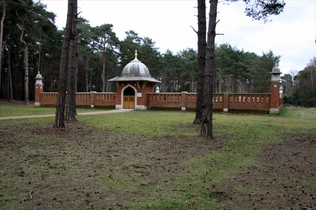
This unique Grade II listed site is situated among pine trees, tucked away on the south east corner of Horsell Common. Designed by architect T H Winney and built by local Woking firm, Ashby and Horner Ltd, it is bounded by ornate brick walls and has a domed archway entrance and minaret, reflecting the design of the nearby Shah Jahan Mosque. The site was completed in 1917 with 19 bodies being received from Brighton during the First World War but a total of 27 with subsequent burials from the Second World War.
In 1921, the Commonwealth War Graves Commission took over the upkeep of the site. Local people remember that it had a yellow path, iron gates at the entrance and two seats inside. All the graves faced east according to Islamic custom.
With later burials taking place at Brookwood Cemetery the Horsell site fell out of use. During the 1960s the site was vandalised and the bodies were removed to the Military Cemetery section at Brookwood.

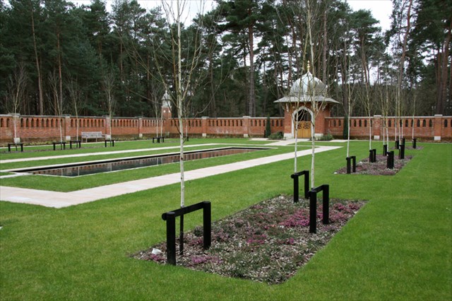
During the summer of 2013, works to restore the unique Grade II listed Muslim Burial Ground to its former glory and create a garden of peace and remembrance commenced. Funding and support from a number of organisations, including Woking Borough Council, Historic England, Armed Forces Covenant Grant Scheme, Department for Communities and Local Government, Shah Jahan Mosque, Surrey County Council, and the Sultanate of the Government of Oman has helped create an Islamic style garden within the walled structure for visitors to enjoy its tranquillity, and to reflect on the sacrifices made by those servicemen who gave their lives in battle during two World Wars.
The Peace Garden features 27 Himalayan birch trees representing the number of servicemen formerly buried at the site, a water feature incorporating a memorial stone bearing their names, bold strips of pink and white heather orientated towards Mecca, scented plants such as Rosa rugosa and Sarcococca orientalis, two stone ceremonial prayer mats, and benches. The garden is a significant heritage site for Woking and will provide a focal point for acts of commemoration and remembrance.
The garden was officially opened by HRH The Earl of Wessex, KG, GCVO, on 12 November 2015.
About Wherigo Reverse Caches:
Wherigo Reverse Caches were inspired by the original Reverse Geocache Puzzle Box
The cartridge for the Wherigo version was developed by -Waldmeister- and has been re-used in many difference caches.
About this Geocache:
To find the cache you will need to download this Wherigo cartridge to a compatible device
This cartridge will tell you how far it is to the final location but not the direction - you will have to work that out for yourself.
So far so good.
But! In order to activate it you need to enter three 6-digit numbers:
A5E30H
G75F0B
CJ0D60
To find the values of A, B etc. you will need to go to the headline co-ordinates and also to the Peace Garden .
1. At the headline coordinates there is an information board about the burial ground. There is a map indicating a number (A) of present-day countries. The information board is inside a wooden frame, at the top of which are four words. B is the total number of letter E's and letter O's that appear in these words
Now go to the Peace Garden at N51 19.755 W000 32.520
2. At the entrance you will see a plaque with text in two languages. The top line of the English text comprises HJ words.
3. Count how many square/rectangular slabs line one long side of the water feature (ignore the 'L' shaped corner pieces and the narrow channel running from the memorial stone). This number is CD
4. On the memorial stone the top two lines are in two languages. The first two words of the English text comprise E and F letters respectively. The total number of letters in the 3rd and 4th words is G.