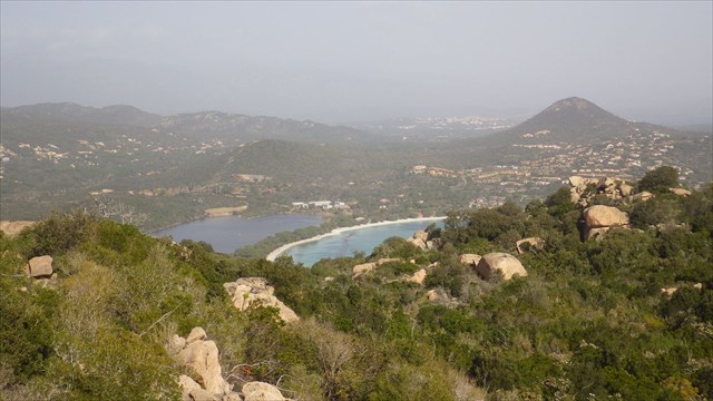

 La plage de Santa Giulia de Porto Vecchio est l’une des plages les plus connues du Sud de la Corse. Située dans un golfe bien abritée, de faible profondeur et composée de nombreux rochers, les fonds marins sont remarquables et d’une clarté exemplaire. Ce vaste golfe est composé de plusieurs plages. La baignade se fait en pente douce. Classer 6 eme plus belle plage de France, (Palombaggia étant la Deuxieme) La fréquentation est très importante en été.
Deux accès pour cette plage que l’on trouve en prenant la direction de Bonifacio en sortant de Porto-Vecchio. Le premier se fait par les Hauts de Santa Giulia. Après le rond-point (intersection pour Ajaccio), continuez sur 2.9 km. Au rond-point, prendre sur la gauche en direction de Bocca Di L’Oru. Suivre la route sur environ 1.5 km puis tournez à droite (de nombreux panneaux publicitaires annoncent les Hauts de Santa-Giulia). Continuez sur 1.8 km puis garez-vous dans la descente.
Le deuxième accès se situe 1.5 km après le précédent rond-point sur la N198. Un panneau indique les différentes infrastructures dans le golfe de Santa-Giulia. Après quelques centaines de mètres, on trouve plusieurs parkings gratuits. Garez-vous rapidement car l’accès est ensuite réservé aux résidents.
A noter que pour le deuxième accès, on trouve un itinéraire aménagé pour les personnes à mobilité réduite (proximité du ponton de Moby Dick - également la seule zone surveillée dans le golfe de Santa Ghjulia).
Le top 10 des plus belles plages françaises selon le Travelers' Choice Plages de Tripadvisor::
1 - Côte des Basques - Biarritz, Aquitaine
2 - Plage de Palombaggia - Porto-Vecchio, Corse
3 - Plage d'Hendaye - Hendaye - Aquitaine
4 -Plage du Touquet - Le Touquet, Nord-Pas-de-Calais
5 - Plage de Pampelonne - Saint-Tropez, Provence
6- Plage de Santa Giulia - Porto-Vecchio, Corse
7 - Plage du Petit Spérone - Bonifacio, Corse
8 - Plage d'Arone - Piana, Corse
9 - Plage d'Espiguette - Le Grau-du-Roi, Languedoc-Roussillon
10 - Plage de Paloma - Saint-Jean-Cap-Ferrat, Provence
La Cache :
Distance : 4,6 Km
Durée : 3h00
Ascension : 250 m
Tracé GPS : Adventure Garmin Santa Guilia Beash
Équipement Obligatoire : Chaussure de Marche, Pantalon, et 1/2 litre d'eau / Personnes. Enfants à partir de 12 ans.
La boucle de Santa Giulia démarre au sud de la plage au point GPS référencé, puis pour nous mettre en jambe un dénivelé de 200 mètres sur 1,3 km vous fera connaître les mérites d'arrivée à la cache.
La redescente est plus calme puisqu'elle se fera par le versant West sur 3 km.
 The beach of Santa Giulia in Porto Vecchio is one of the most famous beaches of southern Corsica. Located in a sheltered bay, shallow and composed of many rocks, the seabed is remarkable and exemplary clarity.This vast gulf consists of several beaches. Swimming is a gentle slope. Sort 6 th most beautiful beach in France, (Palombaggia being the Second) Attendance is very important in the summer.
Both access to this beach that is found by taking the direction of Bonifacio out of Porto-Vecchio. The first is by the Hauts de Santa Giulia. After the roundabout (intersection Ajaccio), continue for 2.9 km. At the roundabout, turn left towards Bocca Di L'Oru. Follow the road for about 1.5 km and turn right (many billboards herald the Hauts de Santa Giulia). Continue for 1.8 km then park in the descent.
The second access is located 1.5 km after the last roundabout on the N198. A sign indicates the various infrastructures in the Gulf of Santa Giulia. After a few hundred meters away, there are several free parking. Pull over quickly because access is then restricted to residents. Note that for the second access, there is a route set up for persons with reduced mobility (near the dock Moby Dick - also the only monitored area in the Gulf of Santa Ghjulia).
The hiding-place : Adventure Garmin Santa Guilia Beash
Distance: 4.6 km - Duration: 3h00 - Ascent: 250 m
Equipment Required: Shoe Walking Trousers and 1/2 liter of water / Persons. Children from 12 years.
Santa Giulia loop starts south of the beach at the point referenced GPS and leg to put us in a vertical drop of 200 meters to 1.3 km you will see the arrival of merits to the cache.
The descent is calmer since it will by the West slope of 3 km.
 Der Strand von Santa Giulia in Porto Vecchio ist eines der bekanntesten Stränden im Süden Korsikas. Das Hotel liegt in einer geschützten Bucht, flach und besteht aus vielen Felsen, ist der Meeresboden bemerkenswert und beispielhafte Klarheit. Diese tiefe Kluft besteht aus mehreren Stränden. Schwimmen ist eine leichte Steigung. Sortieren 6. schönsten Strand in Frankreich, Teilnahme (Palombaggia der Zweite zu sein) ist sehr wichtig, im Sommer.
Sowohl der Zugang zu diesem Strand, die, indem sie die Richtung von Bonifacio von Porto-Vecchio zu finden ist. Die erste ist, die von den Hauts de Santa Giulia. Nach dem Kreisverkehr (Kreuzung Ajaccio), für 2,9 km weiter. Am Kreisverkehr nach links in Richtung Bocca Di L'Oru. Folgen Sie der Straße für ca. 1,5 km und biegen Sie rechts ab (viele Werbetafeln die Hauts de Santa Giulia ankündigen). Fahren Sie für 1,8 km dann in der Abfahrt parken.
Der zweite Zugang ist 1,5 km nach dem letzten Kreisverkehr auf der N198 gelegen. Ein Schild zeigt die verschiedenen Infrastrukturen im Golf von Santa Giulia. Nach ein paar hundert Meter entfernt, gibt es mehrere kostenlose Parkplätze. Ziehen schnell vorbei, weil der Zugriff auf Anwohner beschränkt ist. Beachten Sie, dass für den zweiten Zugang, gibt es eine Route für Personen mit eingeschränkter Mobilität eingerichtet ist (in der Nähe der Anlegestelle Moby Dick - auch der einzige überwachte Bereich im Golf von Santa Ghjulia).
Cache: Adventure Garmin Santa Guilia Beash
Entfernung: 4,6 km - Dauer: 3h00 - Aufstieg: 250 m
Grundstück:
Ausrüstung: Schuhwandern Hosen und 1/2 Liter Wasser / Personen. Kinder ab 12 Jahren.
Santa Giulia Schleife beginnt südlich des Strandes an der Stelle verwiesen GPS und Bein uns in einem Höhenunterschied von 200 m bis 1,3 km zu setzen erhalten Sie die Ankunft der Verdienste in den Cache zu sehen.
Der Abstieg ist ruhiger, da wird es durch den Westen Steigung von 3 km.