Distance : 3,5 Km
Ascension : 92 m
Durée : 1h00
Garmin Adventure
A une dixaines de Kilometres à Partir de Porto-vecchio en direction de Bonifacio;
L'acces au chemins menant à la plage ce trouve juste avant l'entreprise agréga sud corse;
Prevoir une paire de basquette, 1 litres d'eau, et maillo de bain !
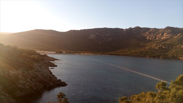
Cette plage n'est fréquentée que par les bateaux qui y viennent chercher un mouillage superbe dans un environnement dénuée de toute construction. La principale raison de cette préservation en est sa relative difficulté d'accès : vous avez le choix, pour aller de la RN198 à la plage W, entre une piste de 3km, réservée aux véhicules 4x4 et démarrant le long d'une carrière en bord de RN198, et un sentier traditionnel de 2km avec passage d'un col à 120m d'altitude. Autant dire que les adeptes de l'accès en voiture à la plage avec parasols, glacières, accessoires de baignade, etc... en sont pour leur frais et préfèrent aller se garer dans les parkings sur-saturés de la Palombaggia ou de Rondinara !
La baie elle-même est superbe, avec un golfe orienté au NE et agrémenté de deux baies perpendiculaires avec toutes deux plage et étang : la baie W, la plus vaste, où arrivent piste et chemin pré-cités et dans laquelle vient se jeter le ruisseau de Porto Novo après avoir irrigué un vaste étang lagunaire et la baie S, plus étriquée mais presque aussi belle, où arrive un ruisseau (sans nom sur IGN) en provenance de la crête de Suartone qui vient lui aussi former un petit étang spectaculaire avant de rejoindre l'extrémité E de la plage.
(http://corse-sauvage.fr/)
Has tens of Kilometers in from Porto-Vecchio towards Bonifacio;
The access to the roads leading to the beach that is just before the company aggregates; Corsican south;
Foresee a pair of basquette, 1 liter of water, and bathroom maillo!
This beach is frequented by boats that will pick a beautiful fountain in a building devoid of ANY environment. The main reason for this preservation is its relative lack of access: you can choose to go to the beach W RN198 between a 3km track reserved for 4x4 vehicles and starting along a career edge of RN198, and a traditional trail with 2km through a pass at 120m altitude. Suffice to say that beachgoers to access by car with umbrellas, coolers, bathing accessories, etc ... are for their costs and prefer to park in car parks on-saturated of Palombaggia and Rondinara!
The bay itself is gorgeous, with a gulf oriented NE and decorated with two bays perpendicular with both beach and pond Bay W, the largest, which arrive track and road pre-listed and in which is throwing the Brook Porto Novo after irrigating a large pond lagoon and the bay S, more narrow but almost as beautiful, where a stream comes (unnamed on IGN) from the peak Suartone which has also just set up a small spectacular lake front joining the E end of the beach.
(Http://corse-sauvage.fr/)