Clifton Suspension Bridge
The original design for a bridge to span the Avon Gorge in Bristol was to be decided by a competition which, in 1829, was judged by Thomas Telford. Telford rejected all the designs and put his own forward which obviously proved very unpopular. A second competition was held in 1830 and 24 year old Isambard Kingdom Brunel was eventually declared the winner and appointed project engineer – his first major commission.
However, financial difficulties and contractual disagreements led to long delays in its construction and it was left for decades unfinished. When Brunel died in 1859, the bridge was still not completed. His colleagues in the Institution of Civil Engineers felt that completion of the Bridge would be a fitting memorial to Brunel, and started to raise new funds to complete it. As Brunel's Hungerford suspension bridge, over the Thames was being demolished at the time, its chains were bought to use at Clifton.
The bridge spans 214 metres between its two 26 metre high towers and stands 76 metres above the high water mark in the Avon river gorge.. Modern computer analysis has revealed that in his design of the crucial joints between the 4,200 links that make up the bridge’s chain, Brunel had made an almost perfect calculation of the minimal weight required to maintain maximum strength.
Although built for pedestrian and horse drawn traffic, the bridge was so ingeniously constructed that it is now capable of carrying millions of cars a year. Recently it was discovered that the bridge’s abutments contain a honeycomb of chambers and tunnels, some of which are 11 metres high. It is thought that these spectacular vaults reduced the cost of construction without reducing strength.
You can read more about the bridge here- Clifton Suspension Bridge Wiki
Brunel's Swivel Bridge
The swivel bridge is Brunel's first large wrought iron opening bridge. It is far older than the Suspension Bridge, and is Bristol's only abandoned Brunel structure. The Bridge is listed Grade 2* and is on English Heritage's Buildings at Risk Register. The bridge rotates on four fixed wheels in contact with a solid ring under the bridge. The bridge was turned by a hydraulic mechanism of twin rams located in pits that are connected to a turning ring under the bridge via a substantial wire cable. The original turning mechanism prior to conversion to hydraulic machinery was a hand turned crank similar to that used on old train turntables. The pistons and chains are still in position. The original hydraulic system ran on fresh water supplied from a pressurised water system sited in Underfall Yard.
Some interesting facts about the bridge-
* The bridge was designed in 1849 by staff in I.K. Brunel's Westminster office to carry traffic over the new South Entrance Lock ('Brunel's Lock') in the Cumberland Basin, which was under construction at the time. The bridge became operational in October 1849.
* Brunel himself was closely involved in both its design and its construction. It represents an early stage in the development of the flanged plate girders that characterised Brunel's later medium span wrought-iron bridges.
* Brunel’s Swivel Bridge, which spanned the new lock, was fabricated at the Great Western Steamship works where the SS Great Britain had been built a few years earlier, and where the ship is now displayed in splendour.
* In 1872-1873 the bridge was shortened and relocated to its present position over the North Entrance Lock ('Howard's Lock').
* The hydraulic machinery of the lock was renewed in 1901-1902, manufactured by Sir W.G. Armstrong, Whitworth and Co Ltd of Newcastle upon Tyne.
* The bridge was decommissioned in 1968 after construction of the nearby Plimsoll Bridge as part of the new Cumberland Basin road system and it narrowly avoided being scrapped when the new bridge was constructed.
You can read more about the bridge and the project to save it at the Brunel's Other Bridge webpage.
Other points of interest on the way-
Clifton Rocks Railway

Thousands of people pass the bottom entrance to the Clifton Rocks Railway as they drive along Bristol's Portway, with most not knowing what secret is buried in the rock of the Avon Gorge. Constructed with great difficulty inside the cliffs of the Avon Gorge in order to reduce its visual impact on the picturesque surroundings, this water powered 'funicular' railway opened on 11 March, 1893 and operated for 40 years against diminishing trade. Its closure in 1934 did not mark the end of its useful life as it became a secret transmission base for the BBC during WWII. It has been empty and disused since the BBC moved out after the war.
You can read more and learn about the restoration project at the Clifton Rocks Railway webpage.
The Cumberland Basin and locks
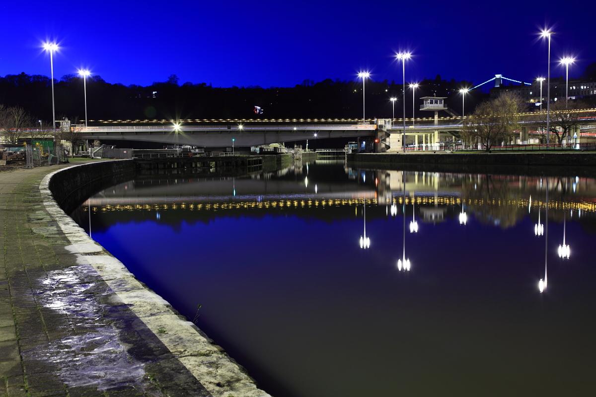
The River Avon never flowed through the Cumberland Basin. Before the 19th century improvements and the construction of the non-tidal Floating Harbour, the Avon flowed through the tidal harbour and out through the future location of the Underfall Yard. When the basin and Floating Harbour were constructed the river was diverted through the New Cut, bypassing the harbour entirely.
Following competition from other ports, in 1802 William Jessop proposed installing a dam and lock at Hotwells to create the harbour. The £530,000 scheme was approved by Parliament, and construction began in May 1804. The scheme included the construction of the Cumberland Basin, a large wide stretch of the harbour in Hotwells where the Quay walls and bollards have listed building status.
The new scheme required a way to equalise the levels inside and outside the Dock for the passage of vessels to and from the Avon, and bridges to cross the water. Jessop built Cumberland Basin with two entrance locks from the tidal Avon, of width 45ft (13.7m) and 35ft (10.7m), and a 45 feet (13.7m) wide junction lock between the Basin and what became known as the Floating Harbour. This arrangement provided flexibility of operation with the Basin being used as a lock when there were large numbers of arrivals and sailings. The harbour was officially opened on 1 May 1809. Brunel was the first to carry out alterations with the construction of the south junction lock which was completed in 1849 and had a single-leaf wrought-iron gate. It is no longer used and has been sealed by a concrete wall.
You can read more about the history of the harbour here- Bristol Floating Harbour Wiki
The Geocache!
At the posted coordinates you will find a lovely view, and a wooden post. On the wooden post there are two numbers, each embossed in a metal disc.
Top number = A
Bottom number = B
Now head off to the next set of coordinates, via the rock slide if you like! You can also take a walk on the bridge.
N 51° 27.261 W 002° 37.540
At this location you will find an information sign. In what year was the project completed? Year numbers = CDEF
Grab a photo before it's time to head down. Follow the zig zag path down to the Portway and to the next location:
N 51° 27.190 W 002° 37.609
On the other side of the road opposite the railway station you will see a lamppost, what is the number on it? Number = GH
Now cross the Portway, I highly recommend walking into Hotwells and crossing at the lights.
This would be a good time to take a look at Church Micro 7476...Hotwells - Grenville Chapel
If the lock gates are closed double back to a gate here:
N 51 27.012 W 002 37.490
Now make your way to:
N 51° 26.969 W 002° 37.459
Here you will find what I believe to be a large bollard. How many holes are in the white ring that runs around it near the top? Number of holes = I
Next it's on along the lock to a lovely view point at:
N 51° 26.888 W 002° 37.444
Take in the view, what year were the works initiated? Year = 196J
Now it is best to double back, and head off to examine the other bridge here:
N 51° 26.919 W 002° 37.378
Enjoy the engineering, now what is the registered charity number referred to on the signs? KLMNOP
You can now head under Plimsoll bridge to the final cache location:
N 51° A(L-C).P(D-F)(H-K) W 002° JL.(M-I)E(N-O)
If you want to find the bonus in the Avon series please be sure to get the bonus info from the cache!
Please no spoilers or photos that may give away cache location!
Enjoy!