En 1893, une délibération du conseil municipal change le nom en « Le Monêtier-les-Bains » afin de développer le thermalisme, lié à une source thermale réputée pour ses propriétés gastriques, rumathologiques et dermatologiques. Cette source était déjà connue au temps des Romains, quand le village s'appelait Stabatio. Les habitants du Monêtier sont surnommés « les tripes chaudes » (en occitan vivaro alpin las tripas chaudas) puisqu'ils soignaient certains maux en buvant l'eau (chaude) de la source.
In 1893, a deliberation of the city council changed the name to "Le Monêtier-les-Bains" to develop hydrotherapy, linked to a hot spring known for its gastric properties rumathologiques and skin. This source was already known in Roman times when the village was called Stabatio. The inhabitants of Monêtier are nicknamed "hot guts" (in vivaro Alpine Occitan las tripas chaudas) since they were treating certain illness by drinking water (hot) source.
Le village du Monêtier est édifié sur du tuf (Calcaire) déposé par les eaux de la source. Le tuf était jadis utilisé comme matériau de construction. L'eau Sulfatée et Calcique, circule à une profondeur de 1000m environ avant de jaillir à une température proche de 38°.
The village of Monêtier is built on the tuff (Limestone) deposited by the waters of the source. The tuff was once used as a building material. Water Contains sulphate and Calcium circulates at a depth of about 1000m before rising to near 38 ° temperature.
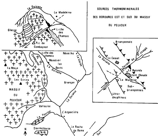
Les sources sont constituées de deux emergences principales : la source de la rotonde à 1500m et la source de Font Chaude à 1440m qui appraissent dans la plaine de la Guisane à travers les formations alluviales et d'un epais massif travertineux qui ont été déposés au fil du temps par ces sources.
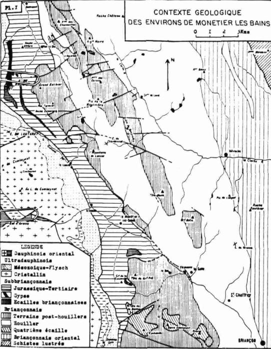
Elles se situent encore au sud d'un accident de type dextre et de direction N40° E qui affecte au niveau du torrent de St Joseph les formations briançonnaises et les gypses qui jalonnent leur chevauchement.
The springs have two main emergences: the spring of "the rotunda" (alt 1500m) and the spring of "Font Chaude" to (alt 1440m) which appear in the Guisane valley through the alluvial formations and a massive thick travertine that were filed over time by these springs.
They are located south of a dextral type of accident and N40 ° E direction that affects at the St Joseph torrent briançonnaises and gypsum formations that mark their overlap.
Les eaux sont de teneurs Chlorosulfatés, Calciques et Sodiques, les fortes teneurs en SO4, Cl, Na, F et Li confirmeraient l'origine triasique des eaux. Les fortes variations en teneur des ions majeurs principaux confirment les effets de dilution par les eaux superficielles non minérales.
La source de la Rotonde de Monetier est composée de 20% d'eau chaude profonde sans tritium et 80% d'eau superficielle venant de la nappe de la Guisane.
The waters have high chlorosulfates, calcium and sodium levels (SO4, Cl, Na, Li and F) wich confirm the origin of the Triassic waters. The large variations content main major ions confirm the effects of dilution by non-mineral surface waters.
The source of the Rotunda Monetier is composed of 20% deep hot water without tritium and 80% of surface water from the sheet of Guisane.
Loguez cette cache "Found it" et envoyez-moi vos propositions de réponses aux questions suivantes soit via mon profil, soit via la messagerie geocaching.com (Message Center), et je vous contacterai en cas de problème.
Log in this cache "Found it" and send me your answers to the following questions via my profile or via geocaching.com messaging (Message Center), and I will contact you in case of problems.
1. Quels sont les trois sortes de dépots caractéristiques de la periode triasique?
1. What are the three kinds of deposits characteristic of the Triassic period?
2. La période triasique est elle anterieure ou posterieure au Jurassique?
2. Does the Triasique period comes before or after the Jurassic one?
3. La temperature de sortie de l'eau varie t elle au cours de l'année, et pourquoi?
3. Does the temperature of the water change during the year, and why?
4. Quel objet trouve t on au sol derrière la rotonde?
4. What's on the ground behind the rotunda?