La "boutonnière" de Ligueil.. EarthCache
La "boutonnière" de Ligueil..
-
Difficulty:
-

-
Terrain:
-

Size:  (other)
Please note Use of geocaching.com services is subject to the terms and conditions
in our disclaimer.
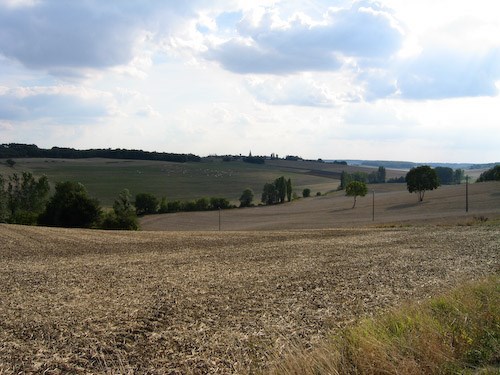
Le Bray de Ligueil.
Une boutonnière est une dépression creusée, par érosion, dans la partie haute de l'anticlinal provoquant une inversion de relief, découvrant des couches géologiques différentes à celle de la surface de l'anticlinal.

Ligueil est située dans une des régions les plus vallonnées de Touraine, aux paysages pittoresques, dus à une spécificité géologique : un dôme anticlinal évidé par l'érosion de deux rivières parallèles : l'Esves et son affluent l'Estrigueil, d'une part, et la Ligoire d'autre part, séparées par un bombement médian : le bray ou "boutonnière" de Ligueil qui s'étend sur une dizaine de communes...
(Ligueil, Civray sur Esves, Bournan, Sepmes, Vou, Varennes, La Chapelle Blanche, Esves le Moutier,etc...)
Histoire géologique du Bray de Ligueil
« Dès la fin de l’Ère Secondaire, des blocs primaires sous-jacents recouverts de plusieurs centaines de mètres de sédiments formèrent un dôme attaqué dès l’exondation tertiaire(Fait, pour une terre inondée, de sortir hors de l'eau) Les premiers épisodes érosifs épandirent sur des surfaces peu à peu nivelées, des dépôts très variés : certaines argiles à silex, des perrons disséminés, des calcaires lacustres.
La mer des faluns apporta ensuite des sables fossilifères originaux, qui ne subsistent qu’en des endroits préservés.
Les reprises d’érosion liées aux grandes glaciations quaternaires, entraînèrent la dissection des surfaces tertiaires.
Les puissantes couches de craie, de marnes, puis de sables de l’Ère Secondaire y furent alors déblayées à l’intérieur du dôme anticlinal de Ligueil.
Celui-ci devint progressivement un ‘bray’, une dépression, où les ressources du sous-sol sont mises à nu. 
POUR VALIDATION DE LA CACHE: REPONDEZ AUX QUESTIONS SUIVANTES:
1) Définition de l'anticlinal ?
2) Définition d'un Bray ?
3) Citez 3 dépots variés dus aux érosions successives du Bray?
4) Citez 3 régions géologiques attenantes à la Boutonnière ?
5) Citez les 4 rivières ayant contribué à la formation de la Boutonnière ?
6) Au W.P:Notez la phrase inscrite au dessus de la porte de la cabane commençant par: La v.........?
7) Photo optionnelle de votre GPS avec la cabane en fond d'image...
Loguez cette cache "Found it" et envoyez-moi vos propositions de réponses soit via mon profil, soit via la messagerie geocaching.com (Message Center), et je vous contacterai en cas de problème.
 A buttonhole is a hollowed depression, by erosion in the upper part of the anticline causing an inverted relief, discovering the different geological layers to that of the surface of the anticline.
Ligueil is located in one of the hilly regions of Touraine, picturesque landscapes, due to geological specificity: an anticlinal dome hollowed by the erosion of two parallel rivers: the Esves and its tributary the Estrigueil one hand , and secondly Ligoire, separated by a median camber: the bray or "buttonhole" Ligueil which extends over a dozen of ...
A buttonhole is a hollowed depression, by erosion in the upper part of the anticline causing an inverted relief, discovering the different geological layers to that of the surface of the anticline.
Ligueil is located in one of the hilly regions of Touraine, picturesque landscapes, due to geological specificity: an anticlinal dome hollowed by the erosion of two parallel rivers: the Esves and its tributary the Estrigueil one hand , and secondly Ligoire, separated by a median camber: the bray or "buttonhole" Ligueil which extends over a dozen of ...
(Ligueil, Civray sur Esves, Bournan, Sepmes, Vou, Varennes, La Chapelle Blanche, Esves le Moutier, etc ...)
Geological history of Bray Ligueil
By the end of the Secondary Era, the play of underlying primary blocks and covered several hundred meters of sediment, bent his latter gradually attacked a dome from the tertiary bank exposure. The first episodes erosive épandirent on surfaces gradually leveled, very different deposits: some flint clay, spread of porches, lacustrine limestones. . The sea faluns then brought the original fossil sands, which remain preserved in places. Reversals of erosion linked to major Quaternary glaciations, led dissection of tertiary surfaces. The powerful layers of chalk, marl and sands of the Secondary Era there were then cleared within the anticlinal dome Ligueil. It gradually became a 'bray' depression, where the resources of the subsoil are exposed. ".
VALIDATION FOR THE CACHE: ANSWER THE FOLLOWING QUESTIONS:
1) Definition of the anticline?
2) Definition of Bray?
3) Name three different deposits due to successive erosions of Bray?
4) Name three geological regions adjoining the buttonhole?
5) Name the four rivers that contributed to the formation of the buttonhole?
6) In WP: Note the phrase inscribed above the door of the hut starting with: v The .........?
7) Optional GPS Photo with cabin background image ...
Log in this cache "Found it" and send me your answers proposals or via my profile or via geocaching.com messaging (Message Center), and I will contact you in case of problems.
Additional Hints
(Decrypt)
Vy a'l n cnf qr yvrh qésvav cbhe y'bofreingvba qr yn "obhgbaavèer" wr ibhf erpbzznaqr yn obhpyr inyybaaér (Q59 & Q99) FRCZRF/OBHEANA/PLIENL FHE RFIRF cbhe yn qvirefvgé qrf cnlfntrf. (yr fcbg fr gebhir yr ybat.)
***********************************************
Gurer vf ab cynpr frg sbe gur bofreingvba bs gur "ohggbaubyr" V erpbzzraq gur uvyyl ybbc (Q59 & Q99) FRCZRF / OBHEANA / PLIENL BA RFIRF gb gur qvirefvgl bs ynaqfpncrf (Nobir vf gur fcbg)