

Géologie  Francais :
Le Calvados recouvre une zone de contact géologique. Il est partagé entre deux domaines contrastés : un socle ancien et un bassin sédimentaire. Situé sur le quart Sud-ouest du Département, le massif ancien se compose d’un ensemble de terrains anciens plissés essentiellement granitiques et schisteux. De formation plus récente (du trias au crétacé), le bassin parisien est composé de couches sédimentaires sub-horizontales sablo-gréseuses, calcaires ou argileuses qui recouvrent le Nord et l’Ouest du département. Plus récemment, au quaternaire, les importantes variations climatiques (glaciations) ont favorisé l’accumulation d’importants dépôts sédimentaires sur le littoral et dans les basses vallées.
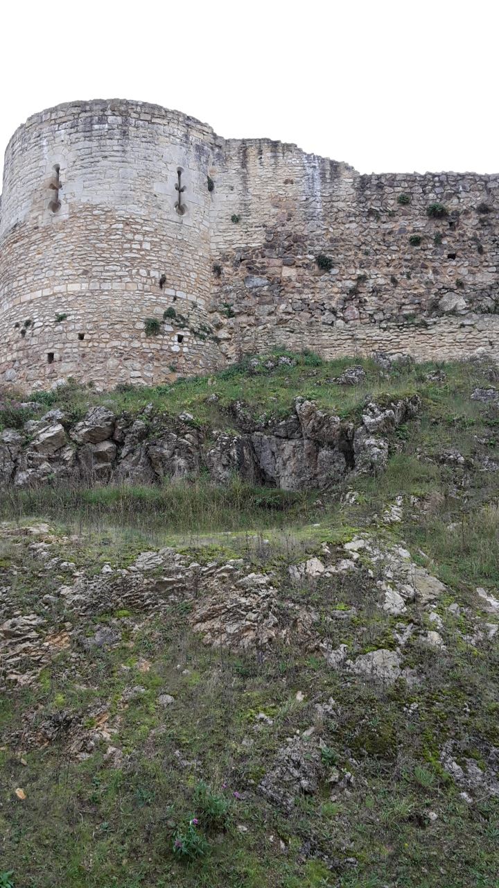
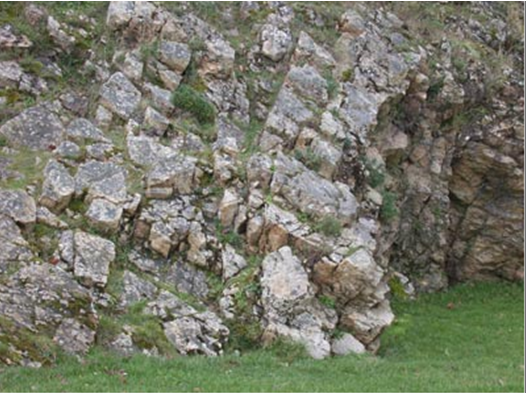
Cet affleurement, dans le secteur Nord-Ouest du rempart du château, permet une mesure de la direction et du pendage du Grès armoricain en position renversée : N130, 50°N. Attention, les plans de stratification peuvent être facilement confondus avec les plans de fracturation ! Le pendage est visible sur cette photo, dans la partie droite.
Geology  English :
Calvados covers a geological contact zone. It is divided between two contrasting areas: a former base and a sedimentary basin. Located on the southwest quarter of the Department, the ancient massif consists of a set of ancient land pleated mainly granitic and schistose. Latest training (Cretaceous to Triassic), the Paris Basin consists of sub-horizontal sedimentary layers sandy-sandstone, limestone or clay that cover the north and west of the department. More recently, quaternary, significant climatic changes (glaciations) have favored the accumulation of significant sedimentary deposits on the coast and in the lower valleys.
This outcrop in the northwestern sector of the ramparts of the castle, allowing a measure of the direction and dip of Sandstone armoricain upside down : N130 , 50 ° N . Please note, bedding planes can be easily confused with fracking plans ! The dip is visible in this picture, the right side .
Pour loguer cette Earthcache : Francais :
Rendez-vous aux coordonnées de la cache afin de répondre aux questions avec l'aide du descriptif de la cache:
1. Quelle est le degré du pendage du Grès armoricain devant vous, aidez-vous de la photo du descriptif de la cache ?
2. Pour être certain de votre passage, derrière vous sur votre gauche se trouve le pont d’accès au château, combien y a t'il de trou sur le mur qui soutient celui-ci ?
3. Merci de vous prendre en photo ou votre GPS autour de ce lieu
"Loguez cette cache "Found it" et envoyez-moi vos propositions de réponses soit via mon profil, soit via la messagerie geocaching.com (Message Center), et je vous contacterai en cas de problème."
To log this Earthcache: French: English :
Go to the hiding contact information to answer questions with the help of description of the cache :
1. What is the degree of dip Sandstone armoricain front of you , help you to picture the description of the cache ?
2. To be certain of your passage behind you on your left is the access bridge to the castle , how many of you it hole on the wall that supports it?
3. Please take pictures or GPS around this place

"Phones Sign the cache" Found it "and send me your answers proposals or via my profile or via geocaching.com messaging (Message Center), and I will contact you in case of problems."