Et la Corse devint une ile
______________________________________________________________________________________________________________________________
La Corse et sa grande sœur la Sardaigne, n’ont pas toujours été des îles.
L’histoire géologique de la Corse s’inscrit dans celle du sud de la France, dont elle fit partie, à part entière, jusqu’à la période du début de leur séparation. Lea position actuelle de la Corse et de la Sardaigne, alignées nord-sud dans le golfe de Gênes, est une acquisition récente, à l’échelle géologique s’entend. Effectivement c'est dans la période du miocène que l'ouverture de la dorsale méditerranéenne va séparer la Corse et la Sardaigne de la Provence.
______________________________________________________________________________________________________________________________
Tectonique
C'est avec les mouvements des plaques tectoniques plaçant progressivement l'Europe face au continent africain que, aux cours de millénaires successifs, d'éruptions volcaniques, en failles ouvertes et autres plissements montagneux, que la Corse et l'ensemble italien vont se détacher du continent pour aller, chacun dans sa dérive, se positionner au beau milieu de la mer Méditerranée.
A l’Oligocène, la distension généralisée entraîne la formation d'un rift d'effondrement d'une partie de l'écorce terrestre, avec formation de bassins continentaux – 35 Ma.
______________________________________________________________________________________________________________________________
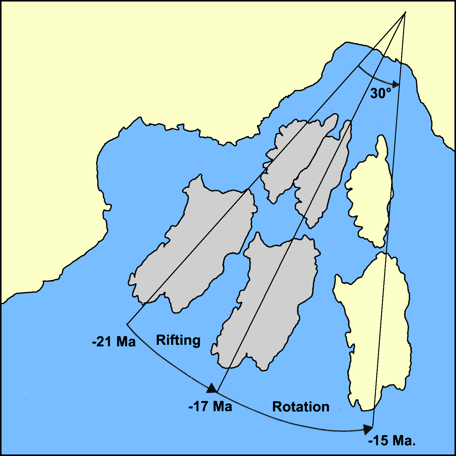
Dérive de la micro-plaque Corse-Sardaigne.
Ce mouvement de dérive aurait débuté peu après les premières manifestations volcaniques. Il aurait tout d’abord consisté en une translation -21 Ma. Le bloc corse et sarde se détacha du continent il dériva dans la Méditerranée. La faille s’élargit. A cette translation aurait succédé, vers -17 Ma, une rotation anti-horaire. La Corse et la Sardaigne pivotèrent d'un angle de 30 degrés en sens inverse des aiguilles d'une montre, pour atteindre sa position actuelle, 2,5 millions d'années plus tard. Ce serait donc à partir de -15 Ma. au plus tard, que la Corse et la Sardaigne ont atteint la position géographique que nous leur connaissons aujourd’hui.
______________________________________________________________________________________________________________________________
Acquisition de l’insularité
En définitive, c’est suite au stade de rifting, suivi du processus d’océanisation qui s’est déroulé au miocène moyen, entre -21 et -15 Ma que la Corse et la Sardaigne ont acquis leur statut insulaire.
Elles vont le reperdre moins de 10 Ma plus tard, au Messinien, (il y a quelques -6 Ma), suite à un assèchement de la mer Méditerranée, provoqué par un déplacement vers le nord de la plaque Afrique. Ce mouvement ayant eu pour effet de fermer le détroit de Gibraltar et de rompre la communication avec l’océan Atlantique, La mer Méditerranée s'assécha pendant. Ceci sur une courte période, car l’ouverture du détroit de Gibraltar à la fin du Messinien, 500 000 ans plus tard, a permis aux eaux marines océaniques de revenir et de remplir le bassin méditerranéen. La communication avec l'atlantique ayant repris, la Corse redevint insulaire.
Au quaternaire, il y eut quatre glaciations successives, et le niveau marin baissa, ainsi, la Corse fut reliée à la Toscane par le pont tyrrhénien (la Tyrrhénide était un continent aujourd'hui disparu qui occupait le centre de la Méditerranée actuelle). Corse et Sardaigne ayant perdu leur barrière marine ont cessé de nouveau d’être des îles. Ce qui, facilitant les communications avec le continent, a peut-être créé les conditions favorables à l’arrivée des premiers hommes sur l’île et leur déplacement à pieds secs vers la Sardaigne.
Vers -0.6 Ma, le niveau marin remonte, la Corse se sépara définitivement du continent, suite à la disparition du pont tyrrhénien, qui la reliait au nord de la péninsule italienne.
Corse et Sardaigne retrouvent alors leur insularité perdue. Insularité qu’elles ne vont plus perdre jusqu’à nos jours.
Et enfin la Corse fut une île !
Actuellement l’expansion océanique dans le bassin Ligure n’est plus active.
On peut voir encore de nos jours que les formes de ces îles s'emboitent bien dans la découpe des côtes de Provence. La séparation s'est faite par une rotation avec une ouverture en ciseaux ou en triangle par rapport au continent.
______________________________________________________________________________________________________________________________
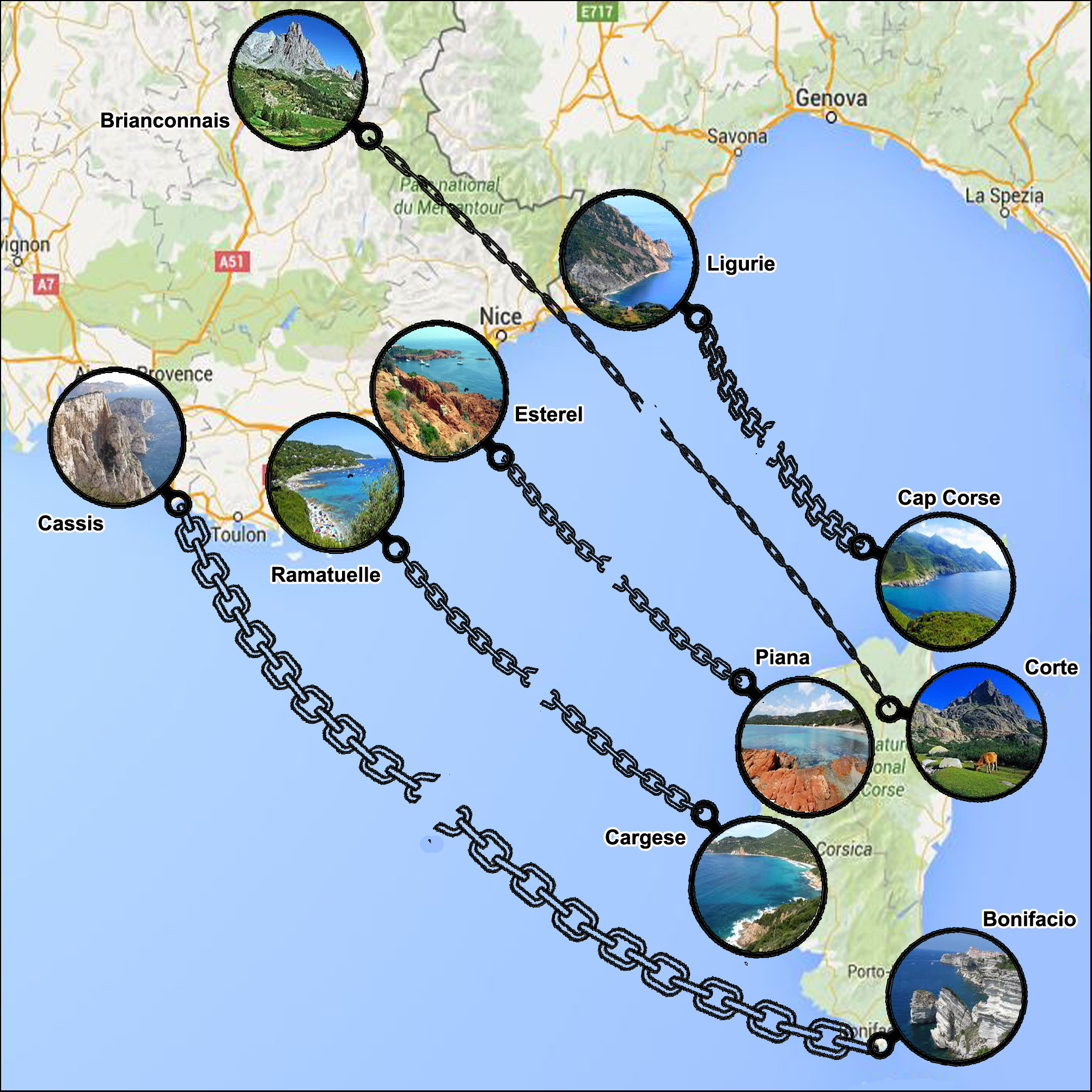
Similitude des paysages.
A l'origine, la Provence, la Corse et la Sardaigne formaient un seul ensemble géologique. C'est pour cette raison, que l’on peut observer des similitudes entre la Corse et l’Estérel. Les roches sont analogues. Un argument Important pour témoigner de leur origine comme avant que la Corse ne dérive.
La zone de Porto-Vecchio avec ses dykes de rhyolite semblables à ceux de l'Estérel.
La zone occidentale Porto - Ajaccio, au sol hercynien est semblable au Massif des Maures.
Le Cap Corse se greffe entre la région de Gênes et Menton où l'on retrouve les mêmes ophiolites.
La région de Corte est construit sur des nappes de charriage correspondant aux terrains du briançonnais.
La zone de Bonifacio, faite de grès calcaires d'origine correspond aux régions de Cassis - La Ciotat.
______________________________________________________________________________________________________________________________
Votre mission
Pour se conformer aux nouvelles directives éducatives pour les Earthcaches vous devez répondre aux quatre questions suivantes.
1 - Quel phénomène a entrainé la séparation de la Corse et du continent?
2 - A quelle époque la Corse a atteint sa position actuelle?
3 - De l’endroit où vous êtes, dans quelle direction et a quelle distance se trouve la Corse ?
Sur place
4 - Faites une description des roches qui vous entourent ( nature, couleur… etc) et que l’on retrouve entre Cargese et Calvi.
Pour justifier de votre passage sur place: Wp question 5 - N43° 26.933 E6° 55.123
5 - Donnez les deux dates entre lesquelles ont etes construits les ouvrages de defenses ?
Loguez cette cache " Found it " et envoyez-moi vos propositions de réponses soit via mon profil, soit via la messagerie geocaching.com (Message Center), et je vous contacterai en cas de problème.
______________________________________________________________________________________________________________________________
Toutes les photos, ne donnant pas d’indices, seront fortement appréciées
_____________________________________________________________________________________________________________
Corsica and Sardinia her big sister, have not always been islands.
The geological history of Corsica is in the south of France, of which it was part, in itself, to the period from the beginning of their separation. Lea current position of Corsica and Sardinia, aligned north-south in the Gulf of Genoa, is a recent acquisition, on a geological scale that is. Indeed it is in the Miocene period that the opening of the Mediterranean will separate dorsal Corsica and Sardinia Provence.
______________________________________________________________________________________________________________________________
Tectonic
It is with the movements of tectonic plates gradually placing Europe facing the African continent that, during successive millennia of volcanic eruptions in other mountain folds open and faults, as Corsica and the Italian ensemble will scrape the continent to go, each in its drift, position in the middle of the Mediterranean Sea.
In the Oligocene, generalized distension causes the formation of a rift collapse of part of the earth's crust, forming continental basins - 35 Ma.
______________________________________________________________________________________________________________________________
Derives from the microplate Corsica-Sardinia.
This drift motion would have started shortly after the first volcanic events. It would initially consisted of a translation -21 Ma. Corsican and Sardinian block broke away from the mainland it drifted in the Mediterranean. The rift widens. At that translation would have succeeded, to -17 Ma, a counterclockwise rotation. Corsica and Sardinia swiveled through an angle of 30 degrees in the opposite direction of clockwise, to its current position, 2.5 million years later. It would be from -15 Ma. At the latest, as Corsica and Sardinia have reached the geographical position which we know them today.
______________________________________________________________________________________________________________________________
Acquisition of insularity
Ultimately, it is following the stage of rifting, followed oceanization process that took place through the Miocene, between -21 and -15 Ma as Corsica and Sardinia have acquired their island status.
They are going to lose again within 10 Ma later, in the Messinian (there are some -6 Ma), following a desiccation of the Mediterranean Sea caused by a northward movement of the African plate. This move had the effect of closing the Strait of Gibraltar and break communication with the Atlantic Ocean, The Mediterranean Sea dried up for. This a short period since the opening of the Strait of Gibraltar at the end of the Messinian, 500,000 years later, allowed the ocean marine waters to return and complete the Mediterranean. Communication with the Atlantic having resumed, Corsica island became.
Quaternary, there were four successive glaciations and sea level lowered and, Corsica was connected to Tuscany by the Tyrrhenian bridge (the Tyrrhénide was now disappeared continent which occupied the center of the current Mediterranean). Corsica and Sardinia have lost their marine barrier stopped again for the islands. This, facilitating communications with the mainland, may have created favorable conditions for the arrival of the first men on the island and their movement on dry ground to Sardinia.
To -0.6 Ma, sea level rises, Corsica is permanently separated from the mainland, following the disappearance of the Tyrrhenian bridge that connected the north of the Italian peninsula.
Corsica and Sardinia then find their lost insularity. Insularity that they will not lose to this day.
And finally Corsica was an island!
Currently seafloor spreading in the Ligurian basin is no longer active.
______________________________________________________________________________________________________________________________
You can still see today that the shapes of the islands fit together well in cutting the coast of Provence. The separation was carried out by a rotation with an opening scissor or delta from the mainland.
______________________________________________________________________________________________________________________________
Similarity of landscapes.
Originally, Provence, Corsica and Sardinia formed a single geological together. For this reason, we can observe similarities between Corsica and the Esterel. The rocks are like. Important An argument to show their origin as before Corsica will drift.
• The area of Porto-Vecchio with rhyolite dykes similar to those of the Esterel.
• The western area Porto - Ajaccio to hercynien ground is similar to the Massif des Maures.
• The Cap Corse is grafted between the Genoa area and Menton where we find the same ophiolite.
• La Corte region is built on thrust sheets corresponding to the briançonnais land.
• The Bonifacio area, made of calcareous sandstone origin corresponds to regions of Cassis - La Ciotat.
______________________________________________________________________________________________________________________________
Your mission
To comply with the new educational guidelines for Earthcaches you must answer four questions.
1 - What phenomenon has led to the separation of Corsica and the mainland?
2 - At what time Corsica has reached its current position?
3 - From where you are, in what direction and how far is Corsica?
On site
4 - Make a description of the rocks around you (type, color etc ...) and that are found between Calvi and Cargese.
To justify your visit on the spot: Wp Question 5 - N43 ° 26 933 55 123 E 6 °
5 - Give the two dates between which the defenses were built're works?
Log in this cache 'Found it' and send me your answers proposals or via my profile or via geocaching.com messaging (Message Center), and I will contact you in case of problems.
______________________________________________________________________________________________________________________________
All photos, not giving clues, will be highly appreciated
______________________________________________________________________________________________________________________________