Sur les "earthcaches", il n'y a ni boîte, ni logbook. Pour valider votre Earthcache il vous suffit de vous rendre sur place et de répondre aux questions posées. Vous pouvez loguer sans attendre mais vous devez me faire parvenir vos réponses en même temps en me contactant soit par mail dans mon profil, soit via la messagerie geocaching.com (Message Center), et je vous contacterai en cas de problème. Les logs enregistrés sans réponses seront supprimés.
On " Earthcaches " , there is no box , no logbook . To validate your Earthcache you just have to go out there and answer the questions . You can log in without waiting but you must send me your answers at the same time by contacting me either by email in my profile or via geocaching.com messaging (Message Center ), and I will contact you in case of problems. Registered logs without answered will be deleted.
On " Earthcaches ", es gibt keine Box, kein Logbook. Um Ihr Earthcache zu validieren müssen Sie nur rausgehen und die Fragen beantworten. Sie können ohne Warten loguen , aber Sie müssen mir Ihre Antworten zur gleichen Zeit senden , Sie können mich kontaktieren entweder per E-Mail in meinem Profil oder über geocaching.com Messaging ( Message Center), und ich werde Ihnen bei Problemen kontaktieren. Log ohne antworten werden gelöscht.
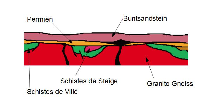
Les Grès
Les grès sont des roches sédimentaires formées par le dépôt puis la cimentation des sables. Dans notre région le grès d'Annweiler (palatinat) est le grès le plus âgé affleurant. On l'appelle également Bundsandstein inférieur. Il est rouge et riche en argile. Dans cette carrière on exploite le grès vosgien, appelé Bundsandstein moyen. Sa couleur est variable, du blanc cassé au rose en fonction des oxydes qui le colorent.
Les bases de notre Earthcache sont posées au Permien (-290 Ma).
La Pangée vient de se formée durant le carbonifère (- 358 Ma) et ce super continent entraîne de grande variation de température et de précipitation donc d'érosion.
- L'érosion des chaînes hercyniennes (grande chaîne de montagne qui se forme, du Carbonifère au Permien, par la collision des continents existants) conduit à des dépôts locaux de sables. Les grès permiens constituent ainsi la première formation de la couverture sédimentaire des Vosges.
- De grande structure volcanique sont associées à cette période et sont à l'origine de la série du Nideck.
- Au Buntsandstein, le massif Vosgien est recouvert par les produits de l'érosion du Massif situé sur l'actuel Bassin de Paris. En Alsace le grès peut être classé dans l'ordre chronologique suivant :
- grès des Vosges (pauvres en fossiles, suite à l'extinction permienne)
- Poudingue de Saint-Odile (ou conglomérat principal)
- grès à Voltzia (riches en fossiles, la vie a repris ses droits) composé de :
- grès à meule
- grès argileux
L'affleurement de Grès vosgien de la carrière de Cleebourg est situé en bordure du horst du Hochwald entre Cleebourg et Rott , à proximité du parking de la Cave vinicole de Cleebourg.
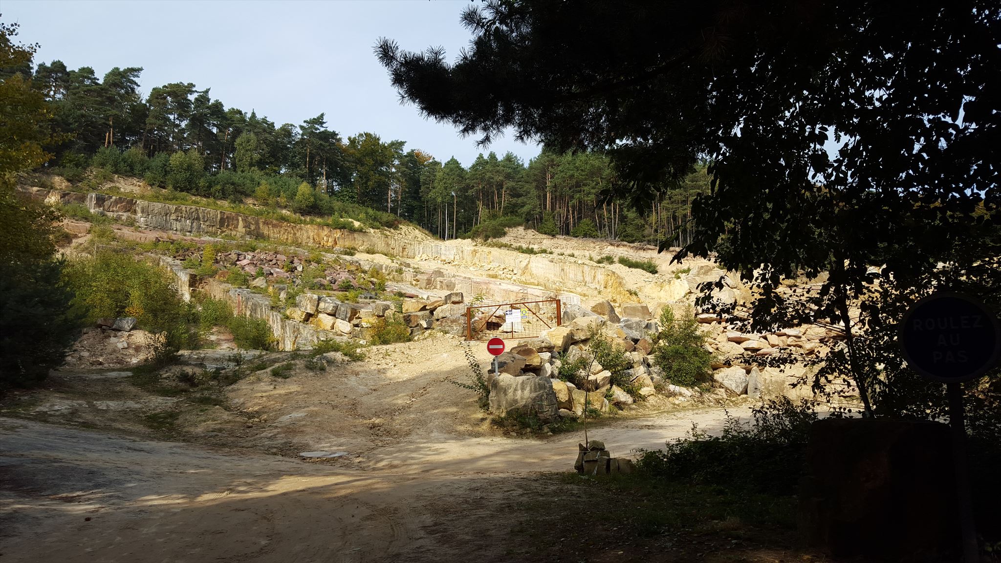
La carrière est installée dans le Grès vosgien qui présente ici deux particularités remarquables :
- La coloration habituelle, rose à rouge, du Grès vosgien est ici pratiquement blanche. Mais on peut observer localement (centre de l'affleurement), des amas de grès plus friable aux teintes roses. La série du Buntsandstein moyen a donc subi une décoloration dans ce secteur.
- L'ensemble des amas lenticulaire (en forme de lentille) est fortement incliné dans le sens de la pente et recouvert d'un manteau d'éboulis. Cependant l'angle de la pente de l'ordre de 30° interdit toute approche du front de taille aux non-professionnels (conditions de terrain de type haute montagne !).
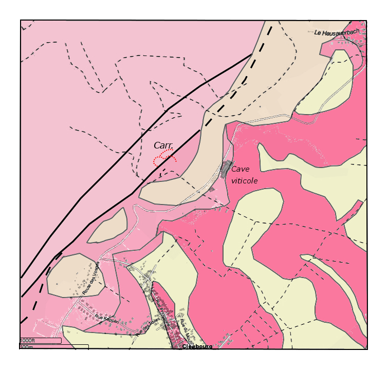
La carte géologique nous montre que la carrière est située à proximité de la faille rhénane qui met en contact les grès du Trias à l'ouest avec les terrains tertiaires du fossé à l'est. La carrière entaille une bande effondrée formant un gradin en coin sur le versant Est du horst du Hochwald.
Sur place l'observation des blocs à l'entrée de la carrière nous montre que la coloration varie du blanc au brun (couleur rouille due aux oxydes et hydroxydes de fer).
L'utilisation de ces grès de Cleebourg en association avec le grès rose traditionnel permet des effets remarquables
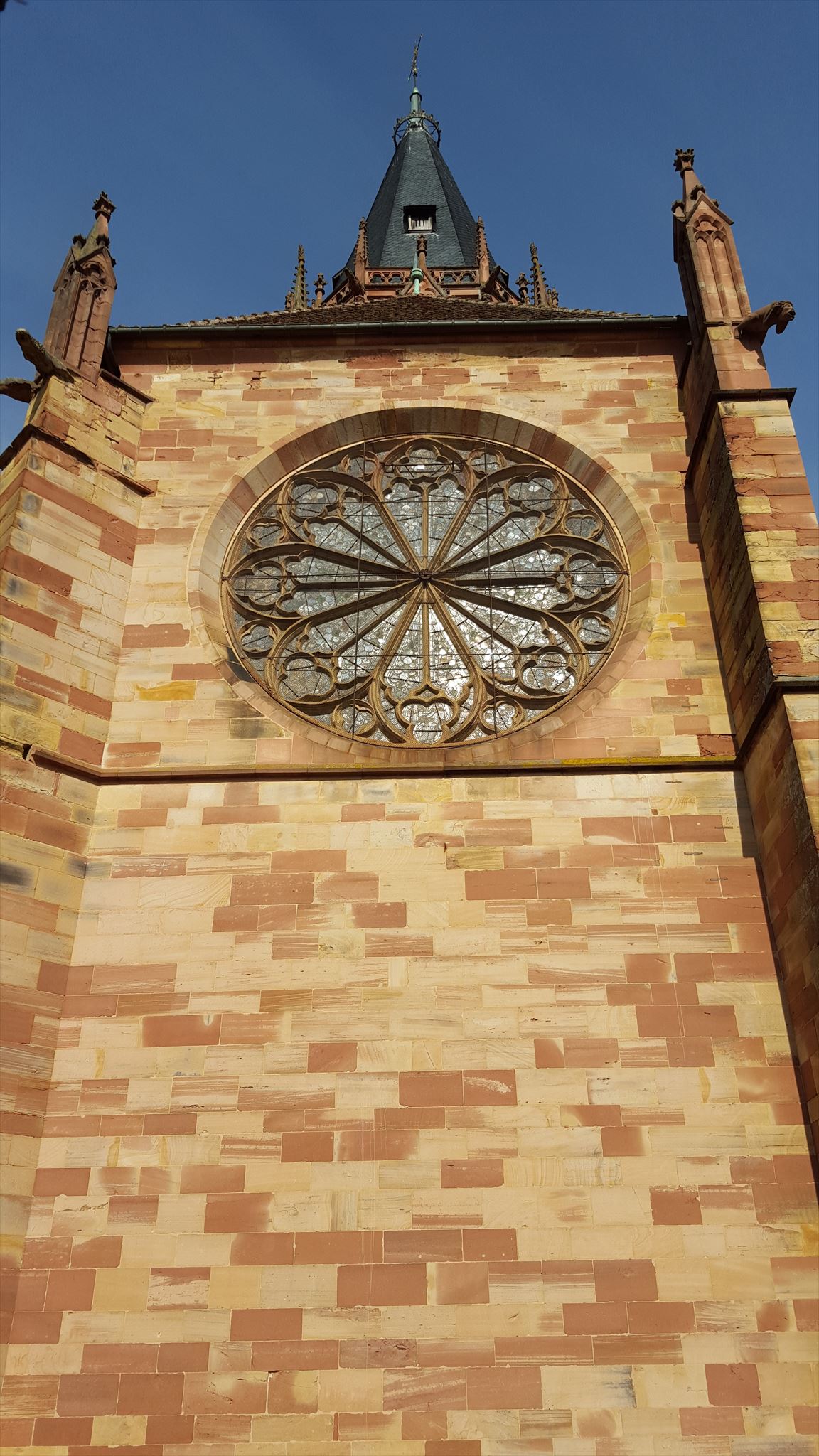
détail de l'église Saint Pierre et Saint Paul à Wissembourg.
Pour valider votre Earthcache veuillez répondre aux questions suivantes :
Qu'a subit le grès du Buntsandstein moyen dans ce secteur ? ( la réponse est dans le texte )
Quelle sont les risques encourue si vous franchissez les deux panneaux jaunes à votre droite ?
Quelle âge à la terre lors de la formation du grès vosgien ?
Cette Earthcache est sur le chemin du « sentier forestier » qui est un parcours permanent de 20 km de la Féderation Française de Sport Populaire dont le départ se situe à la cave vinicole de Cleebourg.
ENGLISH
The Sandstone
Sandstones are sedimentary rocks formed by depositing and then the cementation of sands. In our region Annweiler sandstone ( Palatinate) is the oldest outcropping sandstones. It is also known as New Red Sandstone or Lower Triassic sandstone. It is red and rich in clay. In this quarry, we work Vosges sandstone , known as medium red sandstone. Its colours varies, from off white to pink according to the oxides that colour it.
The bases of our Earthcache are posed to Permian ( -290 Ma)
Pangea just formed during the Carboniferous period (- 358 Ma) and this super continent leads to wide variation in temperature and precipitation, therefore erosion.
- Hercynian mountains chains (large mountain range which were forms from the Carboniferous to Permian, by the collision of continents existing) led to local sand deposits. Permian sandstone are the first formation of the sedimentary cover of the Vosges.
- Large volcanic structures are associated with this period and are at the origin of the series of Nideck.
- At the Buntsandstein, the Vosges mountains are covered by the products of erosion of the Massif on the current Paris Basin. In Alsace sandstone can be classified in the following chronological order:
- Vosges sandstone (fossil poor, following the Permian extinction)
- Poudingue de Saint-Odile (or main conglomerate)
- Voltzia sandstone (rich in fossils, life has reclaimed) composed of :
The Vosges sandstone outcrop of Cleebourg 's career is on the edge of horst Hochwald between Cleebourg and Rott , near the parking lot of the wine cellar of Cleebourg.
The quarry is installed in the Vosges sandstone which presents here two remarkable features:
- The usual color , pink to red , the Vosges sandstone is here practically white . But it can be observed locally ( center of the outcrop ) , more friable sandstone pile pink hues. The series of medium red sandstone has undergone discoloration in this area.
- All lenticular mass ( lens shape) is strongly inclined in the direction of the slope and covered with a coat scree . However, the slope angle of about 30 ° approach prohibits the working face to non-professional ( high mountain terrain type conditions !).
The geological map shows that the quarry is located near a fault. This is the Rhenish fault that connects the Triassic sandstone to the west with the Tertiary of the ditch to the east. Quarry cut a collapsed strap forming a corner bench on the east side of horst Hochwald .
The observation of the blocks deposited at the quarry entrance shows that the color varies from pure white to yellow-brown ( rust color due to iron oxides and hydroxides ) .
Using these Cleebourg sandstone in combination with the traditional pink facies allows remarkable effects
detail of the St. Peter and St. Paul's church in Wissembourg.
To validate your Earthcache please answer the following questions :
What happened to the medium red sandstone in this sector? ( the answer is in the text )
What are the risks incurred if you cross the two yellow signs on your right ?
When the Vosges sandstone was formed, the earth was already ....?..... years old
This Earthcache is on the way of the " sentier forestier " which is a permanent route of 20 km from the French popular sports federation whose departure is located at the wine cellar of Cleebourg
DEUTSCH
Der Sandstein
Sandstein ist eine Sedimentformation die durch die Ablagerung mit anschliessender Zementierung von Sand entstehen. In unserer Region int der Sandstein von Annweiler (Pfalz) der älteste an dder Erdoberflache austretende Sandstein. Man nennt ihn auch unteren Buntsandstein. Er ist rot und weist einen starken Tonerdegehalt auf. In diesem Steinbruch wird Vogesen-Sandstein abgebaut. Seine Farbe schwankt von Wollweiss bis Rosa, je nachdem, welche Oxide ihm seine Farbe verleihen.
Die Grundstein unseres Earthcache sind im Permian (290 mya) gelegen.
Pangea gerade im Karbon (358 mya) geformt werde und superkontinent führt zu großen Unterschiede in Temperaturen und Niederschlägen deshalb Erosion.
- Die Erosion der Herzynischen Gebirgsketten (großen Bergketten, die von Karbon bis Perm, von Kollision von bestehenden Kontinenten sich Formen) führte zu lokalen Sandablagerungen. Permischen Sandstein sind die erste Ausbildung der sedimentären Bedeckung der Vogesen.
- Großer Vulkan Strukturen werden mit dieser Periode zugeordnet und sind die ursache der Reihe Nideck.
- Buntsandstein in den Vogesen wird von den Produkten der Erosion des Massif auf dem aktuellen Pariser Becken abgedeckt Elsass wird der Buntsandstein wie folgt gegliedert:
- Vogesensandstein (arm an Fossilien, nach dem Perm)
- Saint-Odile-Konglomerat („Hauptkonglomerat“)
- Voltziensandstein (reich an Fossilien) besteht aus :
- Grès argileux, im Übergang zum Muschelkalk
- Grès à meule
Die Vogesen Sandstein-Aufschluss von Cleebourg Karriere ist auf dem Rand des horst Hochwald zwischen Cleebourg und Rott, nahe dem Parkplatz der Weinkeller von Cleebourg.
Der Steinbruch liegt in der Vogesen-Sandstein , der hier zwei bemerkenswerte Eigenschaften präsentiert :
- Die übliche Farbe, rosa bis rot, der Vogesen-Sandstein ist hier praktisch weiß. Aber es kann lokal ( Mitte des Zutage ) beobachtet werden , brüchiger Sandstein Haufen rosa Farbtönen. Die Serie der mittleren Buntsandstein hat ein Entfärbung in diesem Bereich durchgemacht.
- Alle linsenförmigen Masse (linsenform) sind stark in der Richtung der Neigung geneigt und mit Geröll Mantel bedeckt. Allerdings die Neigung von etwa 30 ° verbietet die Ansatz die Arbeitsfläche um nicht-professionellen ( Hochgebirge Typ Bedingungen !)
Die geologische karte zeigt, dass der Steinbruch in der Nähe einer Störung sich befindet. Dies ist das rheinische Bruch, dass die Trias Sandstein im Westen mit dem Tertiär Land aus dem Grabens im Osten verbindet . Die Karriere schneidet eine eingestürtzes Band die ein Stufe bildet auf der Ostseite von horst Hochwald .
Vor-Ort- Beobachtung der Blöcke am Eingang zu dem Steinbruch zeigt, daß die Farbe variiert von weiß bis braun (Rostfarbe durch Eisenoxide und -hydroxide)
Unter Verwendung dieser Cleebourg Sandstein in Kombination mit den traditionellen rosa facies ermöglicht bemerkenswerte Effekte
Detail der Peter-und-Paul Abteikirche in Wissembourg.
Um Ihr Earthcache zu validieren beantworten Sie bitte folgende Fragen :
Was ist mit dem mittleren Buntsandstein in diesem Sektor passiert? (die Antwort ist im Text)
Was sind die angefallen Risiken, wenn Sie die zwei gelben Schildern überqueren auf der rechten?
Bei der Entstehung des Vogesen-Sandsteins war die Erde bereits ....?..... Jahre alt.
Dieser Earthcache ist auf dem Weg "sentier forestier", der ein wanderweg von 20 km von der Französischen Volkssportverbandes ist, deren Abreise im Weinkeller von Cleebourg entfernt ist .