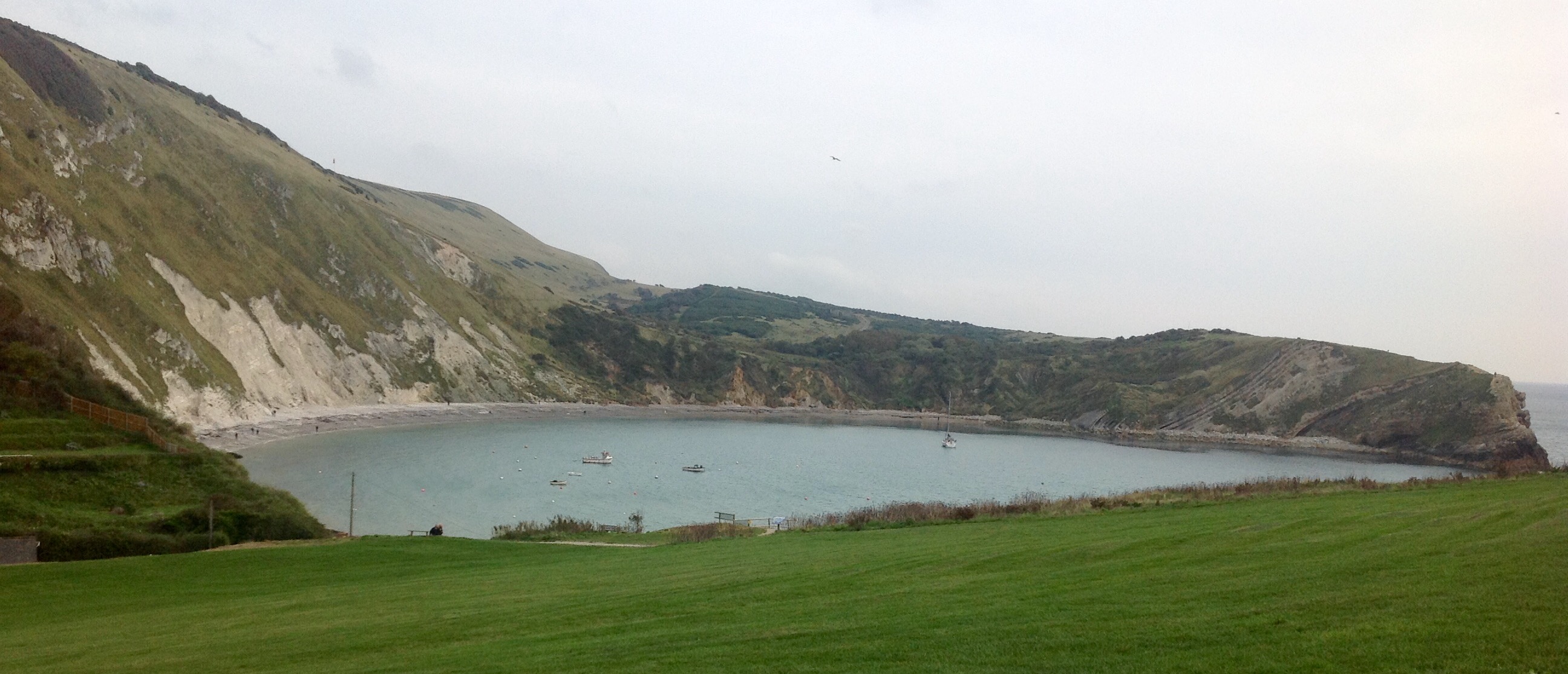
All the natural processes of coastal erosion can be seen here at Lulworth Cove.
There are natural cracks and fissures (joints) in the limestone (Portland Stone) that are widened by the hydraulic action of the pounding waves. Stones and rocks are picked up by the big waves and thrown against other rocks breaking them into smaller pieces. The saltwater itself can form a chemical reaction with the rocks (particularly limestone) which it breaks down. The friction of the waves wears away at the surface of the rocks.
Lulworth Cove was formed approximately 10,000 years ago by the awesome powers of a river and the sea. The unique shape of the cove is a result of the wave diffraction. It continues to evolve behind a narrow Portland stone entrance as the softer Purbeck, Wealdon, Greensand and Chalk exposures are eroded.
The cove has formed because there are bands of rock of alternating resistance running parallel to the shore (a concordant coastline). The seaward side the clays and sands have been eroded away. A narrow (less than 30 metre) band of Portland limestone rocks forms the shoreline. Behind this is a narrow (less than 50 metre) band of slightly less resistant Purbeck limestone. Behind this are 300–350 metres of much less resistant clays and greensands (Wealden clays, Gault and Upper Greensand).
Forming the back of the cove is a 250 metre wide band of chalk, which is considerably more resistant than the clays and sands, but less resistant than the limestones. The entrance to the cove is a narrow gap in the limestone bands. This was formed by a combination of erosional processes by wave action and the processes of weathering. The wide part of the cove is where the weak clays and greensands have been eroded. The back of the cove is the chalk, which the sea has been unable to erode as fast as it does not dissolve in the sea acids.
The unique shape of the cove is a result of wave diffraction. The narrow entrance to the cove ensures that as waves enter they bend into an arced shape this is shown clearly on the photograph
SAFETY FIRST! PLEASE BE CAREFUL, THE COASTAL PATH IS UNSTABLE AT THE MOMENT AND HAS SUFFERED SLIPS LOCALLY. CLIFF EDGES ARE DANGEROUS AND CARRY THE POTENTIAL TO FALL. CLIMBING IS PROHIBITED. ABIDE BY ALL SIGNS.
EarthCaches are a fun and interesting way to learn about geology. Lulworth Cove on the Jurassic Coast in Dorset is amongst the most popular geological site visited by schools and groups. With this in mind, I have set some of the questions for this EarthCache with younger cachers in mind, to encourage them to enjoy learning about geology. At Waypoint 1, you have the opportunity to get up close and personal and touch the rock types that make up Lulworth Cove from a safe position. This is where you will gain the answers to Question 5. You will notice that some of the rock types are used in buildings and structures both locally and further away.
To log this EarthCache: Go to the published Co-ordinates, waypoint and answer the following questions. All answers are on the notice board, by what you can see at the coordinates in the text or at waypoint1. Send your answers to me through the email / messaging service on my profile, please feel free to log before you receive a reply :
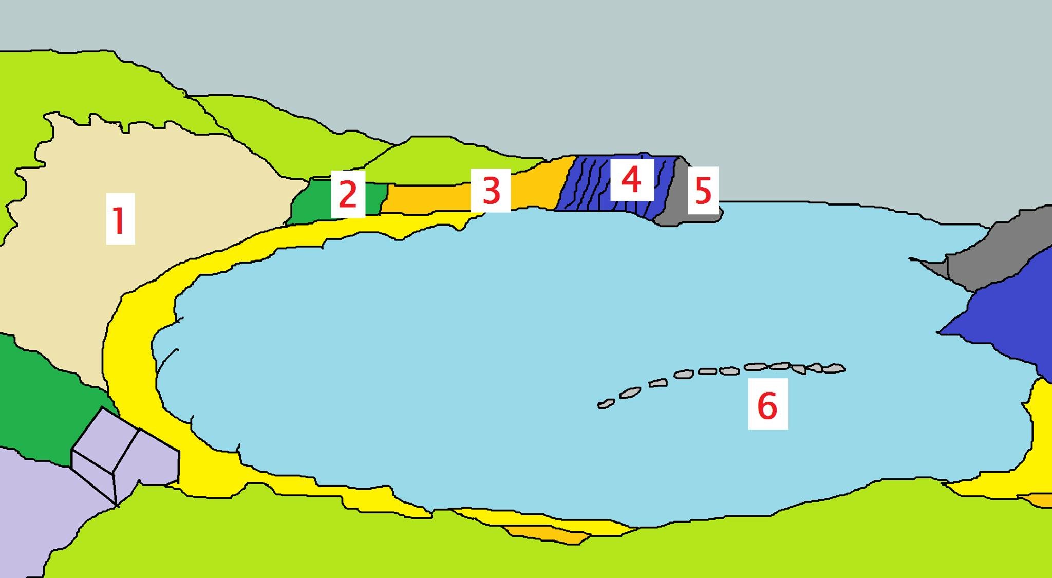
Question 1. What are the types of rock labled 1 to 6 in the above diagram?
Question 2. What type of action gives the cove its unique shape?
Question 3. Describe 2 different types of coastal erosion that can be seen here?
Question 4. How many years ago did the glacial meltwater cut the gap which formed the cove?
Please share your experience in your log. If you wish you can post a photo of you or the views at the GZ (optional)
Disabled Access
Depending on your abilities at the time, you may require assistance to get to the notice board, or have someone take a photo of it for you. Please feel free to contact me for further information. I am happy to help in any way I can.
There is a Visitor Centre and Museum located at the car park where you can learn more about fossils, geology and the history here on the Jurassic Coast, and even buy some replica fossils. There is plenty to do here to enjoy a day out for all ages and lots of designated walks. It is well worth having a look at nearby Earthcache Stair Hole, and for those able to walk / hike up the hill side, you could visit Fossil Forest and Durdle Door EarthCaches.
Many thanks also to nobby.nobbs for his inspiration and hard work in setting up the (now archived) very interesting and successful EarthCache at Lulworth Cove.

Earthcache Souvenir designed by Wesley J Parks wjp666 © With kind permission from wjp666 I will send you the HTML code to place this souvenir on your geocaching profile page when I reply confirming your your answers.