Loess Is More EarthCache
-
Difficulty:
-

-
Terrain:
-

Size:  (other)
Please note Use of geocaching.com services is subject to the terms and conditions
in our disclaimer.
Motorists travelling along Interstate 29 between the Iowa border and St. Joseph, Missouri, enter a desert land, filled with dunes of impressive height. No, they haven’t somehow teleported to the Sahara Desert in some weird teleportation event; they have just entered the loess hills of Northwestern Missouri.
Looking east as one travels north on the interstate, these loess hills are very well illustrated along the east Missouri River valley wall, especially in the area between Rock Port and Mound City. Similar deposits can also be found all along the Missouri River from Kansas City to St. Louis, but they become less impressive and less dune-like, with the exception of Les Mammelles near St. Charles.
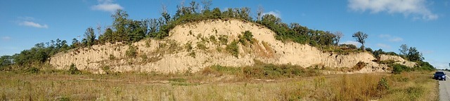
This particular Earthcache will bring you to a great example of this geologic phenomenon in Rock Port, Missouri. Parking is available along the side of the road. It can be busy at times, so be sure to pull off to the side as far as you can and watch the little ones if they are caching with you. You do not have to enter any property to do this Earthcache, as all tasks can be accomplished from the roadside.
•••WHAT IS LOESS?•••
Loess is a unique type of silt that ranges in thickness from a few inches to more than 300 feet. Unlike other soils, loess is pale and loosely packed. Loess usually contains some clay and in some cases, fine sand, a composition that allows it to be easily worked, yet strong and cohesive enough that deep cuts with vertical walls are easily made. In fact, in parts of China residents build cave-like dwellings in thick loess cliffs.
This cohesiveness appears to be a result of two factors, namely it’s composition of exceptionally fine particles, resulting in a molecular attraction acts as a bond as well as the fact that the particles tend to be angular and prone to interlock. A third possible factor may be plant and tree roots, acting as reinforcing rods.
One of the disadvantages of loess, however, is that it loses its cohesiveness once it’s reworked. It crumbles easily; in fact, the word “loess” comes from the German word for “loose.” A chunk of loess can be easily crushed by hand, reducing it to its component fine dust.
Loess in the Midwest is a result of outwash deposited approximately 100,000 years ago during the Pleistocene Period, a time in which meltwater from glaciers filled river valleys so quickly that plant life did not have time to get started in them and thus anchor it. Another factor in its formation was that near the glacier’s edge, temperatures were cold enough to inhibit plant growth. Strong winds picked up this silt and deposited it in the dunes in the downwind side of the valleys.
Extensive loess deposits are found in northern China, the Great Plains of North America, central Europe, and parts of Russia and Kazakhstan. The thickest loess deposits are near the Missouri River in Iowa and along the Yellow River in China.
Loess often develops into extremely fertile agricultural soil. It is full of minerals, drains water very well and is easily tilled for the planting of seeds. In areas of thick loess deposits, farmers utilize the land extensively. In China, for example, farmers have been working the loess near the Yellow River for more than a thousand years.
Loess also is a benefit to local fauna. For example, Bank Swallows carve out nesting areas inside the loess, providing a secure and safe area to live, lay their eggs and protect their young. One can easily identify a nesting colony by the numerous holes that dot the face of the exposed loess.
•••YOUR TASKS•••
Now that we know a bit about loess, let's get to what you need to do to claim this Earthcache smiley! To get credit for this Earthcache, please answer the following questions and send these answers to me via the message center or email.
Any logs that are not accompanied by these answers be silently deleted.
1. Briefly describe how the loess hill that stands before you was formed. Approximately how long ago did this happen?
2. There are three factors that seem to play a role in the cohesiveness of loess. Name two of them.
3. What is your estimation of the height of the loess hill before you?
4. Given the composition of loess, do you think it would make good fill material?
5. Looking at the exposure in front of you, describe any obvious signs of erosion you may see going on. Where is it occurring (i.e., toward the top, bottom, etc.)?
While it isn’t required, a picture of yourself with the loess exposure behind you would be awesome.
•••SOURCES CITED•••
• Beveridge, Thomas. Geologic Wonders and Curiosities of Missouri. 2nd. Rolla, Missouri: Missouri Department of Natural Resources, 1990. 34-35. Print.
• Spencer, Charles G.. Roadside Geology of Missouri. 1st. Missoula, Montana: Mountain Press Publishing Company, 2011. 40-43. Print.
• National Geographic. N.p.. Web. 6 October 2015. http://education.nationalgeographic.com/encyclopedia/loess/

Additional Hints
(No hints available.)