

A marine transgression is a geologic event during which sea level rises relative to the land and the shoreline moves toward higher ground, resulting in flooding. Transgressions can be caused either by the land sinking or the ocean basins filling with water (or decreasing in capacity) (1). – Simply put, it is the advance of the sea over land.
Transgressions can be caused by:
- Tectonic subsidence
- Rise in sea level
- Erosion of shoreline
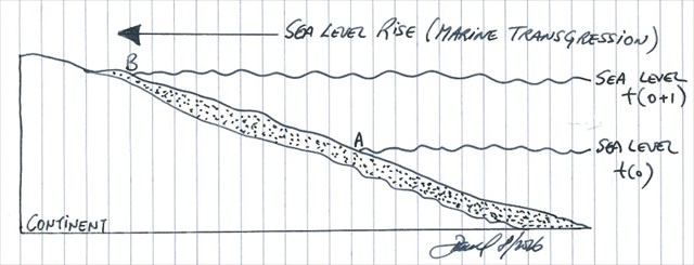
A marine regression is a geological process occurring when areas of submerged seafloor are exposed above the sea level (2). – Simply put, it is the retreat of the sea from the land.
Regressions are caused by:
- Tectonic uplift
- Drop in sea level
- Over supply of sediment

The practical side of things
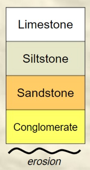
In a regression the vertical column of sediment becomes coarser upwards.
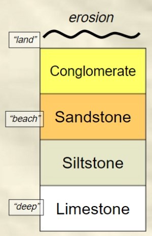
In a transgression the vertical column of sediment becomes finer upwards.
The EarthCache Location
The coordinates for this EarthCache will take you to a rocky outcrop on the western side of S. Julião da Barra Fort located in the eastern extreme of Carcavelos Beach.
Here, you are faced with a sedimentary sequence of rocks that is made up of sandstones and limestones. These are included in the mapped units of limestones and marls of Cretaceous age [Albian; approximate time range is 113.0 ± 1.0 Ma to 100.5 ± 0.9 Ma (million years ago)] (3)(4)
The EarthCache
In order to qualify for a “Found” in this EarthCache, you have to go to the coordinates and walk towards and away from the sea so as to cross the sedimentary sequence and then answer the following questions correctly:
- How thick do you estimate the limestone layer to be? (Remember, I want true thicknesses)
- How thick do you estimate the sandstone layer to be? (Remember, I want true thicknesses – you can take the eastern limit as the fort wall)
- Having studied the sedimentary sequence in question and the cache page, tell me whether you think the sediment package represents a marine transgression or regression. Why?
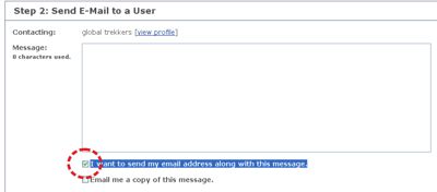
If you feel you have all the answers correct, please log your found but also send me the answers via e-mail so I can check them. If I don’t answer you it is because they are correct and you have another found. Please note that when you e-mail me, please supply the reference (GC64K9B) and name (Transgressions & Regressions, DP/EC 80) of the cache and please click on the “I want to send my e-mail address along with this message” so that when I reply to you the messages don’t go into e-mail heaven (or hell).
References:
- https://en.wikipedia.org/wiki/Marine_transgression
- https://en.wikipedia.org/wiki/Marine_regression
- Ramalho, M.M., Ribeiro, M.L. and Seralheiro, A., 1999. Folha 34-C (Cascais), Escala 1:50000, Instituto Geológico e Mineiro.
- Ramalho, M.M., Rey, J., Zbysweski, G., Matos Alves, C.A., Palácios, T, Moitinho de Almeida, F., Costa, C. and Kullberg, M, 2001, Notícia Explicativa da Folha 34-C (Cascais), Instituto Geológico e Mineiro.

A transgressão marinha é um evento geológico, durante o qual o nível do mar sobe em relação à terra e a costa move em direção a um terreno mais alto, podendo dar resultado a inundações. Transgressões marinhas podem ser causadas pelo afundamento de terra ou as bacias oceânicas de enchimento com água (ou diminuição da capacidade) (1). – De uma forma muito simples, é o avanço do mar sobre a terra.
Transgressões podem ser causadas por:
1- Subsidência tectónica
2- Subida do nível do mar
3- Erosão da linha de costa
Uma regressão marinha é um processo geológico que ocorre quando áreas de fundo marinho submerso ficam expostas acima do nível do mar (2). - Simplificando, é o recuo do mar da terra.
Regressões marinhas podem ser causadas por:
1- Levantamento tectónico
2- Queda no nível do mar
3- Com o fornecimento de sedimentos
O lado prático das coisas
Numa regressão, a coluna vertical de sedimentos (para cima) torna-se mais grosseira.
Numa transgressão a coluna vertical de sedimentos (para cima) torna-se mais fino.
A localização da EarthCache
As coordenadas para esta Earthcache irão levá-lo a um afloramento rochoso no lado ocidental Forte de S. Julião da Barra que está localizado no extremo leste da Praia de Carcavelos.
Aqui, você depara-se com uma sequência sedimentar de rochas que é composta por arenitos e calcários. Estes são incluídos nas unidades mapeadas de calcários e margas de idade do Cretácico idade [Albiano; intervalo de tempo aproximado é de 113,0 ± 1,0 Ma a 100,5 ± 0,9 Ma (milhões de anos)] (3) (4)
A EarthCache
Para poderes logar o teu "Found" nesta Earthcache, tens que ir para as coordenadas. Aqui é preciso fazer um corte (caminhar tanto na direcção do mar como da terra) de modo a atravessar a sequência sedimentar aflorante e, em seguida, responder correctamente às seguintes perguntas:
1- Qual a espessura estimada da camada de calcário? (Lembra-te que quero as medidas verdadeiras da camada e não a medida virtual)
2- Qual a espessura estimada da camada de arenito? (Lembra-te que quero as medidas verdadeiras da camada e não a medida virtual) - podes tomar o limite oriental como a parede do Forte)
3- Tendo estudado a sequência sedimentar em questão e a página de cache, diz me se achas que o pacote de sedimentos representa uma transgressão ou uma regressão marinha. Porquê?
Se achas que tens as respostas correctas, faz o teu log de "found", mas envia-me também as respostas por e-mail para que eu possa vê-las. Se eu não te responder é porque elas estão correctas.
Por favor, nota que quando me enviares um e-mail, por favor forneçe a referência (GC64K9B) e nome (Transgressions & Regressions - DP/EC 80) da cache e clica em “I want to send my e-mail address along with this message”para que quando eu responder as mensagens não sigam para o saco roto do geocaching.com.

 The most exciting way to learn about the Earth and its processes is to get into the outdoors and experience it first-hand. Visiting an Earthcache is a great outdoor activity the whole family can enjoy. An Earthcache is a special place that people can visit to learn about a unique geoscience feature or aspect of our Earth. Earthcaches include a set of educational notes and the details about where to find the location (latitude and longitude). Visitors to Earthcaches can see how our planet has been shaped by geological processes, how we manage the resources and how scientists gather evidence to learn about the Earth. To find out more click HERE.