Sentier Géologique du Wolfloch
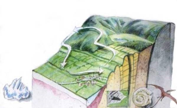
La colline de Lauw-Sentheim est exceptionnelle, car s'y trouvent réunis sur moins d'1 km², des terrains d'âge primaire, secondaire, tertiaire et quaternaire, qui nous permettent de traverser 350 millions d'années d'histoire géologique en seulement 3 heures !
(Source : http://www.geologie-alsace.fr/index.php/sentiersmusee.html)
Le Jurassique en Alsace :
Situation géographique : proche de l’équateur.
La région est envahie par une mer chaude avec des variations de niveau, entrainant la précipitation de calcaire (oolithique, ferrugineux, récifal) lorsqu’elle est peu profonde et agitée par les vagues et courant.
Lorsque la mer est plus calme et plus profonde, les particules argileuses provenant de l’érosion de terres émergées lointaines se déposent et se combinent au carbonate de calcium marin pour donner les marnes.
La première étape du sentier nous conduit à découvrir les calcaires oolithiques du Bajocien Bathonien.
Pour valider cette earthcache répondez aux questions suivantes
- A quel système et série géologique appartient le Bajocien et le Bathonien ?
- De combien de Ma d’années séparent le début de Bathonien et la fin du Bajocien, d’après la Commission internationale de la stratigraphie ?
- Au départ du sentier sur le pont se trouvent des panneaux expliquant l’évolution géologique de la terre. Trouvez les 5 évènements importants du jurassique et cité le troisième.
- Complétez la phrase suivante : Les oolithes sont des formations ????? présentant à leur centre un ???? autour duquel on observe des structures ????? formées de calcaire.
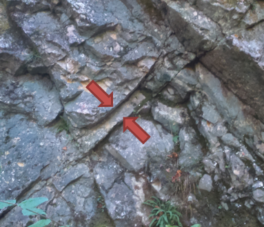
- Aux coordonnées vous pouvez apercevoir le plan incliné ci-dessous. Mesurées la distance en cm entre les flèches.
Vous pouvez loguer cette cache "Found it". Envoyez-moi vos propositions de réponses soit via mon profil, soit via la messagerie geocaching.com (Message Center), et je vous contacterai en cas de problème.
The Wolfloch Geological trail
Hill The Lauw-Sentheim hill is exceptional because one can found on less than 1 sq km land of primary, secondary, tertiary and quaternary era, which allow us to pass through 350 million years of geological history only in 3 hours!
(Source: http://www.geologie-alsace.fr/index.php/sentiersmusee.html)
The Jurassic in Alsace:
Location: near the equator.
The area is covered by a warm sea wich had level changes, causing the precipitation of limestone (oolitic ferruginous, reef) when it is shallow and agitated by the waves and current.
When the sea is calmer and deeper, clay particles from erosion of distant land masses are deposited and combine the marine calcium carbonate to give the marl.
The first step of the trail leads us to discover the Oolitic limestone Bajocian Bathonian.
To validate this earthcache answer the following questions
- At what system and geological series belongs Bajocian and Bathonian ?
- How many years separate the early Bathonian to late Bajocian, according to the International Commission on Stratigraphy?
- At the start of the trail on the bridge are signs explaining the geological evolution of the earth. Find the 5 major events of the Jurassic and name the third one.
- Complete the following sentence: The oolites are formations of ????? having at their center a ???? around which ?????? structures formed of limestone are observed
- On cache coordiantes you can see the inclined plane (see picture above). Measured the distance in cm between the arrows.
You can log this cache as "Found it." Send me your answers proposals via my profile or via geocaching.com (Message Center), and I will contact you in case of problems.