
What to do?
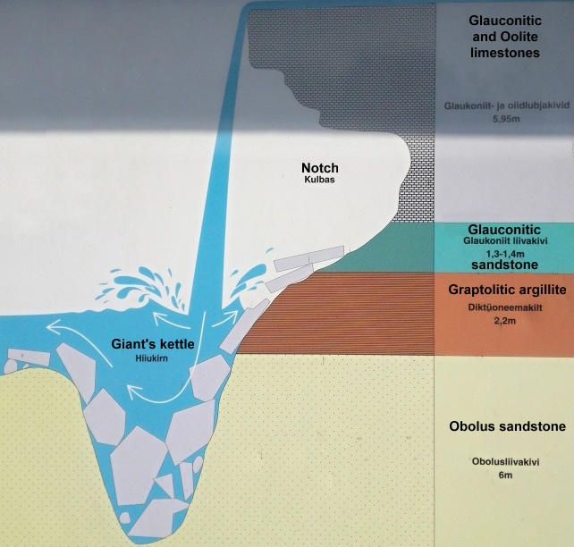
1) In listing of this geocache (or at information tables, which are at each side of the waterfall), you can see that waterfall consists of four types of rock. Which one is softest? Why could you say so?
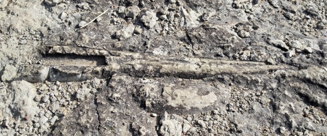
2) Look around you and try to find some fossils. How long they are? In which kind of rock did you find them? If you still can't find them, check the hint. There are hundreds of them mainly on the top of horizontal layers of the rock.
3) Take a photo of you in front of Jägala Waterfall or with any of the fossils found and add it to your log.
After completion of the tasks, send me your answers preferably to email address
puczmeloun@gmail.com with subject
Jagala. You can send me answers through profile or use the Geocaching Message system too. Don't wait for confirmation. If something is wrong, I'll ask you to clarify your answers later.
Mida leiu kirjasaamiseks tegema peab?
1) Infotahvlite juures (asuvad mõlemal pool juga) näed, et juga koosneb nelja sorti kivimist. Milline neist on pehmeim? Miks sa nii arvad?
2) Vaata ringi ja püüa leida mõned kivistised (fossiilid). Kui pikad nad on? Millisest kivimist sa nad leidsid?
3) Palun tee endast Jägala joa juures pilti või mõne leitud fossiiliga ning lisa see enda logile.
Kui ülesanded tehtud, saada oma vastused aadressile
puczmeloun@gmail.com. Kinnitust ei pea ootama. Küsimuste korral võtan sinuga ühendust, et vastuseid täpsustada.
Jägala Waterfall / Jägala juga
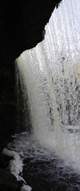
Jägala Waterfall is a waterfall in the lower course of the Jägala River, approximately 4 km before the river flows into the Gulf of Finland. The waterfall is approximately 8 metres in height, more than 50 metres in width and the average discharge of this waterfall is 12.8 m3/s (up to 200 m3/s during the spring high water period). The waterfall forms two strong whirlpools at each edge. Whirlpool at the right shore is stronger - reportedly there is 6 meters deep pit. Jägala river is not that deep here, but its stream is powerful enough to bring away a horse. The waterfall has created some 300 meters long canyon with 12 - 14 meters high rims. Formed on the boundary strata between limestone and sandstone complexes, Jägala Waterfall has been retreating ever since its formation about 3000 years ago, leaving behind a 280 meters long and 10–14 meters deep canyon. In the years 1688–1931 the waterfall retreated at a rate of approximately 17 centimetres per year.
Jägala juga on juga Jägala jõe alamjooksul Harju maakonna Jõelähtme valla territooriumil, umbes 5 km enne jõe suubumist Soome lahte. Kuni 60 m laiuse ja 8 m kõrguse veelangu vooluhulk on keskmiselt 12,8 m3/s (kevadise suurvee aegu kuni 200 m3/s). Tegemist on kõige kõrgema loodusliku joaga Eestis. Mõlema kalda all tekivad suured keerised, mis suunduvad uuesti joa alla kokku, ja alles siis tormab vahutav vesi üle kivide ning suurte paepankade edasi. Eriti tugev keeris on parema kalda all, kuhu olevat tekkinud kuni 6 m sügavune süvend. Pöörleva jõe jõust annavad tunnistust augu põhjast lahtirebitud ja väljapaisatud kiltkivi tükid. Juga asub pae- ja liivakivilasundi piiril ja on u 3000 aastaga endast maha jätnud 280 m pikkuse ja 10–14 m sügavuse kanjonoru. Aastatel 1688–1931 taandus juga kiirusega u 17 cm aastas.

The North Estonian Klint / Põhja-Eesti klint
The North Estonian Klint, a steep limestone "coastal escarpment" that in many places edges Estonia’s northern coast, is one of the most prominent nature monuments in northern Estonia. North Estonian Klint is also a singular boundary structure, marking the boundary between two extensive structures of the Earth’s crust: The
Baltic Shield (sometimes referred to as the Fennoscandian Shield) and the
East European Platform.
Põhja-Eesti klint on eelkõige Balti klindi astangud Põhja-Eesti rannikul Osmussaare ja Narva vahemikus, samuti murrutusastangud
Fennoskandia (Balti) kilbi ja
Ida-Euroopa platvormi piiril, st kõvade kristalsete ja pehmemate settekivimite piiril. Linnulennult on Põhja-Eesti klinti, olgu siis üht- või teistpidi tõlgendatult, u 300 km ehk ligi neljandik u 1200 km pikkusest Balti klindist.

The extent of Baltic klint from Öland Island to Lake Ladoga is about 1200 km.
The Baltic Shield is 1.5 billion to 2 billion years old and consists mainly of strongly folded crystalline rocks, while the East European Platform is represented by relatively soft sedimentary rocks that are non-metamorphized and often horizontally bedded. Thus, to the north of the klint crystalline rocks of an ancient shield crop out (e.g., the rocks that are exposed in Helsinki and elsewhere in southern Finland). The klint itself is the northern boundary of the sedimentary rocks of a huge platform structure. The sedimentary beds have a slight southward inclination. For example, in northern Estonia the sedimentary cover is about 100 meters thick, but in southern Estonia its thickness has increased to almost 800 meters and continually increases toward Latvia and Lithuania, where the thickness reaches several kilometres.
Balti klint algab Ölandi saare läänekaldalt. See on ligi 1200 km pikkune, Rootsi ranniku lähedalt algav ja üle Balti mere ja Eesti põhjaranniku kuni Venemaa Laadoga järve lõunakaldani ulatuv aluspõhja kivimitesse murrutatud astangute süsteem. Ölandilt pärineb ka selle pinnavormi nimetus “klint”, mis rootsi keeli rannaastangut tähendab. Balti klint, kuigi oma ulatuselt pikk, ei ole kusagil nii suursuguselt võimas kui Eesti põhjarannikul. Balti klint jaguneb astangute iseärasustest lähtuvalt neljaks alalõiguks ehk regionaalseks klindiks. Läänest itta liikudes oleksid need: Ölandi, Läänemere, Põhja-Eesti ja Ingeri klint.

Simplified north-south geological cross-section through the Gulf of Finland
The North Estonian Klint is remarkable not only in terms of its escarpments but also the waterfalls and cascades descending from them. Of the 32 waterfalls and cascades of the Baltic Klint, 29 are located on the North Estonian Klint or on structural units connected with it. The limit from which a descent of water is regarded as waterfall has been conventionally set in Estonia at 1 meter for a waterfall and 1.5 meter for a cascade. Of the 31 water descents of the North Estonian Klint, only 6 (Keila, Vääna, Jägala, Nõmmeveski, Joaveski, Narva) are located on rivers with a considerable discharge (average discharge above 1 m3/s), while the remaining 25 are located on small rivers (average discharge less than 1 m3/s) and streams or even drainage ditches. The height of the falls and cascades in the North Estonian Klint zone ranges from 1 to 30 meters but most of the falls are less than 10 meters high.
Eestis on kokkuleppeliseks piiriks, kust veelangu hakatakse joaks nimetama, võetud 1 m. Joastiku puhul on see piir 1,5 m. Balti klindil on neile tingimustele vastavaid veelange 32 ja 29 neist asuvad Põhja-Eesti klindil. Viimastest vaid 6 (Keila, Vääna, Jägala, Nõmmeveski, Joaveski, Narva) on arvestamisväärse (keskmiselt üle 1 m3/s) vooluhulgaga jõgedel ning ülejäänud 23 väikejõgedel ja ojadel-kuivenduskraavidel (keskmine vooluhulk alla 1 m3/s).

Waterfalls in the North Estonia
Orthoceras
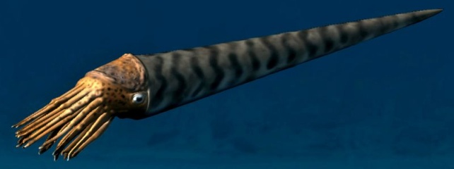
In the rock all around the waterfall we could find also fossils of ancient cephalopods. Orthoceras genus, which is related to current octopuses and squids, means in literal translation "straight horn" and it is dated to the lower Ordovician to Triassic ages (500 to 190 million years ago). The Orthoceras ranged in size from a few inches in length to over six feet. They could swim as well as crawl on the ocean floor. By filling the chambers in their shells with air they could float through the seas propelling themselves by squirting jets of water. As they died their shells accumulated upon the ocean floor, then covered by sediments they transformed into stone over the ages.
Stones that consist of monospecific assemblages of orthocone cephalopods are known as cephalopod beds in the geological literature. Based on studies of size distributions of the orthocone shells, it had been argued that these assemblages likely represent post-mating mass deaths, as are common among modern cephalopods (though not modern nautiloids) and indeed among many semelparous species. More recent taphonomic and sedimentologic studies argue that such "beds" are the result of the gradual accumulation of orthocone shells over an extended period of time in areas with very low rates of sedimentation and strong bottom currents. One of the most famous areas is the one at the Baltic island of Öland off the southern coast of Sweden. For centuries Öland has supplied greater Europe with material for floors, stairs and grave stones.

Orthoceras- ehk vaginatum-lubjakivi. Eesti ja naaberalade, sealhulgas Peterburi ümbruse ning Rootsi nautiloide sisaldavaid lubjakive hakati 19. sajandil nimetama Orthoceras-lubjakivideks (sks. Orthocerenkalk) või ka vaginatum-lubjakivideks. Nime andis sellele lubjakivile juba enne Linné-aega kirjeldatud sirge kojaga fossiil Orthoceras, mis sai hiljem tuntuks kui Orthoceras vaginatum. Kuigi nüüdisaegse süstemaatika järgi kuulub neis kivimites leiduvatest nautiloididest vaid osa seltsi Orthoceratida, kasutatakse seda mitteametlikku ajaloolist nimetust peamiselt Kesk-Ordoviitsiumi vanusega (umbes 470–460 mln. a.) lubjakivide kohta seniajani.
See lubjakivi tekkis kunagise Baltika mandri äärealasid katnud meres – ajal, mil kontinent ise paiknes praeguse asendiga ligikaudu samaväärsetel lõunapoolsetel laiuskraadidel. Kui seda kivi hoolega uurida, siis leiab sealt peaaegu kõik tollest ajast tuntud fossiilirühmad. Tõsi, kuigi spetsialistile äratuntavad, on enamik neist kivististest lagunenud liivatera suurusteks osakesteks; kuid mõnekümne sentimeetri pikkused nautiloidide kojad, suurematest rääkimata, torkavad hästi silma.

Jägala Waterfall is protected natural object. The river area, that is down from the waterfall, is a conservation area and Natura 2000 site. Since you want to observe the Jägala waterfall and the activity does not harm the waterfall, The Environmental Board gives permission for Geocaching at Jägala waterfall. Official placement permission could be found
here.
***
Jägala juga on looduskaitse objekt. 2003. aastal moodustati Jägala joa ja suudme vahemikus Natura 2000 hoiuala. Keskkonnaamet on andnud ametliku loa Maaaarde paigaldamiseks Jägala joale, kuniks soovitakse juga vaid vaaldelda ning oma tegevusega seda ei kahjustata. Ametlikku luba näete
SIIT.