The Mount Tahoma Trails Association operates and manages the largest no-fee, hut-to-hut trail system in North America for cross-country skiing and snowshoeing. Approximately 50 miles of trails (20 miles of which are groomed) provide safe and easy access to three ski huts and a yurt. Trails vary from novice to expert, are well-signed, and are patrolled by an all-volunteer ski patrol.
The North District combines beginner-friendly hut access with miles of groomed and backcountry trails. Copper Creek Hut is an excellent 4-mile day or overnight destination trip and a popular route for families with young children. The South District offers unmatched views of Mount Rainier, High Rock, Griffin Mountain, and all of the Gifford Pinchot National Forest, even though you’re seldom above 4,500 feet. Two huts and a yurt are positioned within the South District, offering rest and quiet seclusion.
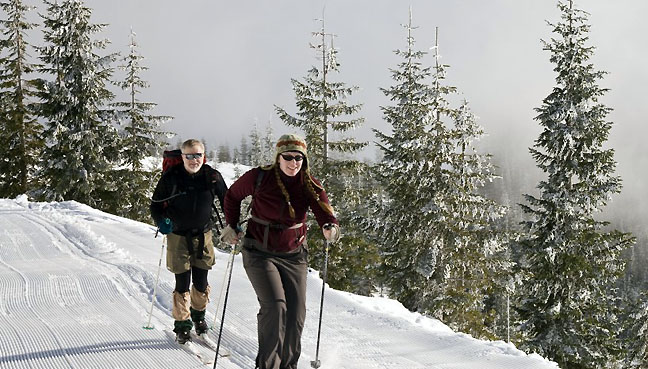
In summer, the landscape shifts to a mountain biker and hiker’s playground. The trails gradually wind through the ridges and valleys of the South Cascades, offering stunning views of its three volcanoes: Mt. Rainier, Mt. St. Helens, and Mt. Adams. Trails vary from novice to expert and are well marked. Spend several nights at a hut; enjoy the clean mountain air; take in the extraordinary, above-the-cloud sunsets. There are no parking fees or passes required for summer day visits.
The cache: This cache is placed in the North District, near the Beaver Lake trailhead. To reach the cache location, follow Hwy 706 east, and turn left on 278th Ave E (also signed FS92) about one mile west of Ashford. Continue 3.7 miles and turn left; you'll see signs for the ORV camp and Beaver Creek trailhead. Go 0.1 mi. and turn left. Go 1 mile and bear right, continue 1 mile to trailhead on the left.
Notes: This cache may not be accessible in winter due to snow. Also, while this land is maintained by the Washington DNR, it is state land and requires a Discover Pass for parking.

2016 was the 100th anniversary of the National Park Service, and to celebrate, Visit Rainier and WSGA are hosting the Visit Rainier Centennial GeoTour - 100 caches placed in and around Mount Rainier National Park. The geocaches highlight the rich history, scenic wonders, quaint communities, and hidden gems of the Rainier region.
The caches were released in four series of 25 caches each during 2015 and 2016. Participants record their finds in passports, which may be turned in upon completion of each series to receive a prize. Each series has a unique prize, and a commemorative geocoin is awarded to those finding all 100 GeoTour caches (while supplies last).
The Rainier Centennial GeoTour is sponsored by Visit Rainier and Washington State Geocaching Association (WSGA). We hope you enjoy touring the Mount Rainier area as much as we do!

