|
The Cache
The cache is within a half mile of the car park along a rather level and easy trail. The cache itself is 180 feet off the trail with minimal bushwhacking required. There are a few small logs in the area that can be avoided by choosing the right route in. There was evidence of Elk all along the trail and in the area of the cache.
|
 |
 |
Driving Directions
Heading east on State Route 410 from Enumclaw, pass through the little village of Greenwater for a couple miles until reaching US Forest Service Road 70. Head east for nine miles and look for the large sign pointing to the Greenwater Trails car park. The road and car park are paved and are suitable for all vehicles. A mile beyond the turn of on FS70 is a winter Snow Park Area
|
|
Location
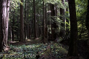
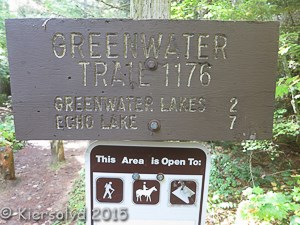
The trail to Greenwater Lake is a family friendly, fairly level trail that is enjoyable year round. Snow free from May through October, it is an enjoyable hike even in the snow. The hike to Greenwater Lakes is two miles with 200 feet elevation gain. Picturesque with deep, old-growth Douglas Fir groves, bridges, waterfalls, and lakes. Beyond the lake are Echo and Lost Lakes, each about 3.5 miles more with a steeper grade for a more strenuous destination.
|
 |
|
History
The Naches Trail crosses the Cascades Range through Naches Pass to the east of here. The area was used by Native Americans as a travel route from Yakima to Puget Sound to trade and to gather food. Later, the route was used by fur traders and settlers. One of the earliest written accounts of the use of this trail tells of the travel of a Lt. Johnson of the United States Exploring Expedition (Wilkes Expedition), crossing on horseback, as the Expedition explored the Pacific Northwest in 1841. The first settlers crossed in September and October 1853, running into such difficulties as low food, lowering the wagons down steep cliffs, and crossing the White River numerous times. A few years later, Snoqualmie Pass was determined to be superior for cross state travel. In the 1920s, Ezra Meeker lobbied for a state highway through Naches Pass, but Chinook Pass was selected instead. State Route 168 is a legislated but not constructed highway that would cross Naches Pass.
|
Parking Fees
In the summer, a Northwest Forest Pass is required. In the winter, a State Park Sno-Park Permit is required.
References
- Visit Rainier - Summer Time
- Visit Rainier - Winter Time
- Naches Trail
- Wikipedia - Naches Pass - SR168
- Parking Passes
2016 was the 100th anniversary of the National Park Service, and to celebrate, Visit Rainier and WSGA hosted the Visit Rainier Centennial GeoTour - 100 caches placed in and around Mount Rainier National Park. The geocaches highlighted the rich history, scenic wonders, quaint communities, and hidden gems of the Rainier region. Participants received geocoin and pathtag prizes for finding all the caches.

