Le Sentier des Sols / The Soils' Trail
Le sol est la partie la plus superficielle de la croûte terrestre, véritable interface entre biosphère et lithosphère. Cette formation est d'ailleurs le produit résultant de la transformation de la roche mère sous-jacente au contact de l'atmosphère et des êtres vivants sous l'influence de processus physiques, chimiques et biologiques.
D'une importance primordiale, il pourtant souvent mal connu. Cette anonymat se retrouve dans le panorama des caches géologiques, ou la science du sol, ou pédologie, est peu présente.
Un petit test... Vous pouvez certainement nommer 3 types de roches, 3 types de minéraux... Mais êtes vous capable de citer 3 types de sol ?
Cette série de caches géologiques, ou plutôt pédologiques, va être l'occasion de partir à la découverte de cet univers du sol en s'appuyant sur le Sentier des Sols, un très beau circuit pédagogique mis en place sur la commune d'Osenbach.
Chaque cache géologique sera l'occasion de découvrir un type de sol, ses caractéristiques, ses propriétés et sa formation, grâce à des panneaux explicatifs et à des coupes de sol, dont la majorité a été prélevée sur le territoire de la commune.
The soil is the outermost part of the Earth's crust, real interface between biosphere and lithosphere. It is also the product resulting from the processing of the underlying bedrock with the influence of the atmosphere and living beings under the influence of physical, chemical and biological process.
On paramount importance, yet it often poorly understood. This anonymity is reflected in the panorama of geological caches where the soil science, has little presence.
A small test ... You can certainly nominate three rock types, 3 types of minerals ... But are you able to quote 3 soil types?
This series of caches geological, or rather soil ones, will be an opportunity to explore this ground, so complex and so diverse, relying on the Soils' Trail, a very nice educational tour set up on the town of Osenbach.
Each geological cache will be the occasion to discover a type of soil, its features, its properties and its formation, through explanatory panels and soil sections, the majority was taken in the soils of the municipality.
Quelques définitions pédologiques / Pedological definitions
- Roche mère : roche sous-jacente dont la dégradation est généralement à l'origine de la fraction minérale du sol.
-Bedrock : underlying rock whose degradation is usually the source of the mineral fraction of the soil.
- Horizon : le sol présente deux fractions (organiques et minérales) qui se mélangent à des degrés divers selon la profondeur et donnent différents niveaux parallèles à la surface au sol, appelées horizons, d’abord humifères, puis minéraux. Ils sont généralement désignés par une lettre et ses dérivés (O ; A/A1 ; E ; B ; S / Sal ; C ; R).
- Horizon : the floor has two fractions (organic and inorganic) that mix to varying degrees depending on the depth and provide different levels parallel to the ground surface, called horizons, first humus and minerals. They are generally designated by a letter and its derivatives (O; A / A1; E; B; S / Sal, C, R).
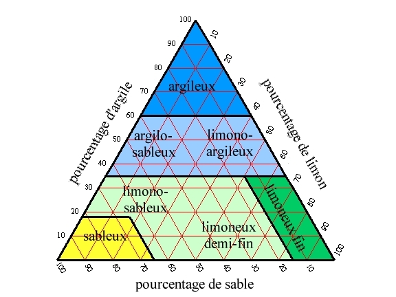
- Granulométrie : La classification de la fraction minérale se fait principalement sur le diamètre de ces éléments (granulométrie) :
• les graviers et cailloux (> 2 mm)
• les sables (20 µm-0,2 mm)
• les limons (2 µm-20 µm)
• l'argile granulométrique (< 2 µm)
- Particle size : the classification the mineral fraction is mainly on the diameter (particle size) : :
• gravel and pebbles (> 2 mm)
• sands (20 .mu.m-0.2 mm)
• silts (2 .mu.m-20 .mu.m)
• particle size clay (<2 microns)
- Texture : Le niveau de granularité et la proportion de chaque taille d’éléments minéraux détermine la texture du sol (sol sableux, limoneux ou argileux, ainsi que toutes les variantes intermédiaires).
- Texture : The level of granularity and the proportion of each size of mineral elements also determine the soil texture (sandy, loamy or clay soil, as well as all the intermediate variants).
- M.O. : Matière Organique, issue de la décomposition des êtres vivants (végétaux et animaux) et formant la fraction organique du sol.
- M.O. : Organic matter derived from the decomposition of living organisms (plants and animals) and forming the organic fraction of the soil.
Le sol : Alocrisol sur grès / Soil : Alocrisol on sandstone
L'alocrisol, appelé aussi sol brun acide ou sol brun ocreux, est un sol relativement organique, léger et bien agrégé, acide, contenant des quantités importantes de fer et d'aluminium échangeables.
► Caractéristiques
La majorité du matériel de départ de l’alocrisol est une roche acide (ici du grès), ce qui donne au sol sa coloration rougeâtre.
Ce sol contient cependant des limons et argiles en part non négligeable (32%) d’origine éolien. Ils se sont déposés il y a 20000 ans alors que la région connaissait un climat périglaciaire.
Cet alocrisol présente une texture sablo-limoneuse sur 4 horizons, avec un premier horizon organo-minéral peu épais. Il est dominée par les sables fins, avec une faible teneur en argile. Ce sable, nommé altérite, est issu de l’altération du grès. Sa proportion est cependant plus faible que dans d’autres types de sols vosgiens, ce qui en a bloqué la podzolisation.
Son pH est acide (inférieur à 5), dû à l’acidité de la roche mère, roche sédimentaire détritique ayant comme roche d'origine un granite.
► Formation
Le sol acide brun de la région est issu d’une dégradation du grès sous l’action de l’eau, qui a dissous le ciment du grès en ainsi libéré les minéraux de cette roche sédimentaire détritique qui était issue d’un matériel plutonique (granite), c'est-à-dire le quartz, feldspaths et micas.
Les felspaths et micas se sont dégradés en fer (Fe), aluminium (Al) et argile, alors que le quartz, peu altérable, est resté en l’état sous la forme de sable, formant un altérite (horizon C). En dessous, la couche R de la roche mère n'a pas évolué (couche géologique).
Ces éléments minéraux se sont mélangés dans la partie superficielle à de la manière organique (M.O.) pour former un complexe argilo-humique en surface (horizon A1, le chiffre "1" caractérisant une richesse en matière organique) puis une couche d'altération riche en alumine (Sal), mais qui a peu pénétré dans le sol.
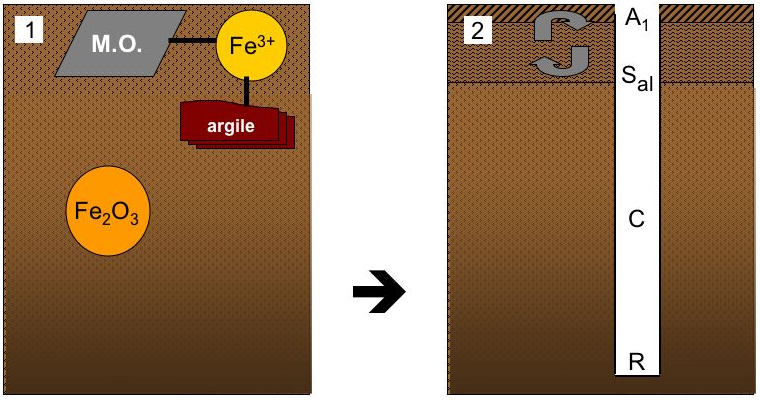
Dans ce type de sol, le fer libéré sous forme ionique joue un rôle fondamental en constituant un pont entre argile et matière organique, pour former le complexe argilo-humique indispensable à la fertilité du sol.
The alocrisol, also called brown acid soil brown or ocher soil, is a relatively organic soil, light and well aggregated, acid, containing significant amounts of iron and exchangeable aluminum.
► Caracteristics
The majority of the starting material of the alocrisol is an acid rock (sandstone here), which gives the soil its reddish color.
This soil contains however silts and clays with significant proportion (32%). This material, with wind origin, was deposited 20,000 years ago when the region knew a periglacial climate.
This alocrisol has a sandy-loam texture of 4 horizons with a first organo-mineral horizon thin. It is dominated by fine sand with low clay content. This sand named alterite, is obtained from the alteration of the sandstone. Its proportion is, however, lower than in other types of soils Vosges, which has blocked the podzolisation.
Its pH is acidic (less than 5), due to the acidity of the rock, clastic sedimentary rock with original rock like granite.
► Rock formation
Brown acid soil of the region is the result of a deterioration of the sandstone under the action of water, which dissolved the sandstone cement and minerals released this detrital sedimentary rock after a plutonic materials (granite) , ie quartz, feldspar and mica.
The felspaths and mica deteriorated iron (Fe), aluminum (Al) and clay, while quartz, little alterable, remained in the state in the form of sand, forming a alterite (horizon C).
Below, the horizon R of the rock has not changed (geological layer). These mineral elements are mixed in the surface with organic way to form a clay-humus complex in surface (horizon A1), then a layer of alumina-rich alteration (Sal), but that has little penetrated into the soil.
In this type of soil, iron released in ionic form in order to play a fundamental role in bridging between clay and organic matter (M.O.) to form the clay-humic complex, material essential for soil fertility.
Les Questions / The Questions
La lecture attentive du descriptif de la cache, ainsi qu'une observation des éléments de terrain et un peu de déduction sont normalement suffisants pour répondre aux questions de cette EarthCache.
A careful reading of the description of the cache, as well as observation of terrain features and some deduction is usually sufficient to answer questions of this EarthCache.
Questions pour valider :"Alocrisol sur grès"
Questions to validate: "Alocrisol on sandstone"
Vous voici devant un panneau explicatif présentant cet alocrisol, ou sol brun acide, accompagné d’une coupe de ce sol prélevée à quelques mètres du panneau.
You are before an explanatory panel about this alocrisol (soll acid brown) accompanied by a sample of the soil sampled a few meters of the panel.
- Question 1 : Observer la répartition granulométrique de ce sol. En fonction de cette composition, comment qualifieriez-vous sa texture ?
- Question 1 : Observe the particle size distribution of the soil. Depending on the composition, how would you describe its texture ?
- Question 2 : Comment se nomme les limons d’origine éolien qui constituent la particularité de ce sol brun acide ?
- Question 2 : What is the name of the original wind silts that form the special feature of this acid brown soil?
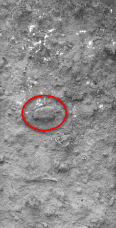
- Question 3 : Quelle est la longueur du morceau de grès du début d’horizon C (voir photo ci-dessous) ?
- Question 3 : What is the length of the piece of sandstone at the top of horizon C (see picture below)?
- Question 4 : Quelle est la coloration des 5 premiers centimètres du sol ? Quelle est l’origine de cette couleur ? Déduisez-en le nom de cet horizon.
- Question 4 : What is the color of the top 5 cm of soil? What is the origin of this color? Deduct in the name of this horizon.
Vous pouvez vous loguer sans attendre notre confirmation,
mais vous devez nous envoyer les réponses en même temps soit par mail via notre profil (
fafahakkai), soit via la messagerie geocaching.com (Message Center).
S'il y a des problèmes avec vos réponses nous vous en ferons part.
Les logs enregistrés sans réponses seront supprimés.Une photo de vous ou de votre GPS en Noir & Blanc près du point zéro sera la bienvenue, mais n'est pas obligatoire. Vous ne devez photographiez ni les panneaux, ni les coupes de sol !
You can log this cache without waiting for our confirmation, but you must send us the answers at the same time, by e-mail via our profile (fafahakkai) or by the system of Message Center of geocaching.com.
If there is a problem with your answers we will notify you. The logs recorded without answers will be deleted.
A picture of yourself or your GPS in Black & White with the view from the front of the rock of Geissfels would be welcome but is not mandatory.
Rappel concernant les « Earthcaches »: Il n'y a pas de conteneur à rechercher ni de logbook à renseigner. Il suffit de se rendre sur les lieux, de répondre aux questions ci-dessus et de nous renvoyer les réponses.
Reminder concerning "Earthcaches": there is neither a container to look for nor a logbook to sign. One need only go to the location, answer to the differents quiestions and send us the answers.