Le cours d'eau
L'encaissement et le creusement de la vallée est dû au creusement par le cours d'eau durant les périodes glaciaires en même temps que le plateau se soulevait.
Le cours d'eau draine partiellement la nappe phréatique qui circule dans le bas de la vallée. Il reçoit les eaux de ruissellement du bassin versant.
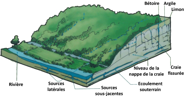
La source
D'où vient l'eau ?
Le plateau de Caux est constitué essentiellement de calcaire sous des couches de limon et d'argile. Les eaux de pluies vont s'infiltrer jusqu'à saturer la partie inférieur de la craie, drainée par un réseau de galeries souterraines et ressortir au niveau d'une source.
L'estuaire
Comme tout cours d'eau se jetant dans la mer, la Durdent est un fleuve malgré sa longueur réduite de 23 km.
La basse vallée correspond à un ancien estuaire barré par un cordon littoral de galets qui fut aménagé au milieu du 18ème siècle.
La rivière communique désormais avec la mer par une buse. L'influence marine se fait néanmoins sentir.
La earthcache

Pour pouvoir valider cette earthcache, vous devrez répondre correctement aux questions suivantes, les réponses figurant sur le panneau d'information situé aux coordonnées de la cache.
Merci d’envoyer vos réponses via mon profil ou via la messagerie geocaching.com, ne les donnez pas dans votre log.
Vous pouvez loguer la cache "found it", je vous contacterai en cas de problème.
1) Quelles sont les deux origines de l'eau alimentant le cours d'eau ?
2) a. Alors que l'argile est une roche normalement imperméable, quelle propriété de celle recouvrant le calcaire permet aux eaux de pluie de s'infiltrer ?
b. Quel autre minéral est contenu dans cet argile ?
3) De quelle manière le cordon littoral a-t-il été aménagé au milieu du 18ème siècle ?
4) Comment l'influence marine se fait-elle sentir sur l'estuaire ?
5) Quelle est l'origine des noms des villes traversées par la Durdent (Paluel, Cany et Vittefleur), en lien direct avec cette vallée ?
6) Vous pouvez également ajouter à votre log une photo de vous ou de votre gps avec la Durdent en fond (facultatif mais grandement apprécié).
the Valley and the Estuary
The water course
The depth of the valley is due to the digging by the river during the ice ages at the same time as the plateau was rising.
The water course drains partially the water table which circulates in the low valley. From time to time rainwater running from the hills around enters the stream which partially heightens the water course.
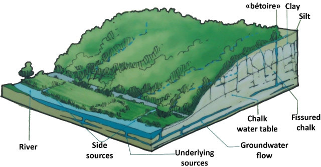
The source
Where does the water come from ?
The plateau of Caux is made up, in essence, of a layer of chalky sediments under beds of silt and clay. Rainwater filters through until it saturates the lower part of the chalk, drained in all directions along a network of subterranean galleries to re-emerge at the level of a spring.
The estuary
Like every water-course entering the sea, the Durdent is a river in spite of its short length (23 km).
The bottom of the valley corresponds to an ancient estuary blocked in the middle of the 18th century by an offshore bar of rollers. From here on the river meets the sea solely through a pipe. Nonetheless the marine influence can still be felt.
The earthcache
To be able to validate this earthcache, you will have to correctly answer the following questions which answers are on the panel at the cache coordinates.
Thank you for sending your answers via my profile or the geocaching.com messaging, don't take it in your log.
You can post your log "found it", I shall contact you in case of problem.
1) What are the two origins of the water feeding the river?
2) a. Whereas the clay is a normally impermeable rock, what property of the clay overlying limestone allows rainwater to infiltrate?
b. What other mineral is contained in this clay?
3) How the offshore bar was modified in the mid 18th century? (answer only in French on the panel)
4) How marine influence is felt in the estuary?
5) What is the origin of the names of towns crossed by the Durdent (Paluel, Vittefleur and Cany), directly linked to this valley?
6) You can also add to your log a photo of you or your GPS in front of the Durdent (optionnal but strongly appreciated).