(eau, vent ou glace). Dans notre cas, la forme et la taille des galets indique un transport par l'eau.
-
la sédimentation ou dépôt.
- la diagénèse, qui modifie le sédiment pour le transformer en roche sédimentaire (ici une roche gréseuse).

Le vecteur principal d'origine des sédiments étant ici l'eau, la nature des débris à l'origine de la roche dépend fortement de la vitesse du courant, comme le montre le diagramme de Hjuström :

The area of Mutzig - Gresswiller is located in a hilly landscape at the heart of the Vosges sandstone, in the intermediate zone of the mountain range.
The course of its slopes and above its peaks is the opportunity to discover a geological formation of the most original, the leading conglomerate, which will allow us to illustrate the principles of the formation of sedimentary rocks whose Vosges sandstone is a remarkable example.
► The local geological context
The area of the peaks bordering the right bank of the Bruche river is located in the heart of sedimentary deposits, composed of Vosges Buntsandstein pink sandstone rocks.
As shown the geologic map, several middle Buntsandstein's sandstone layers have a rapid succession over the slope and that until the sommet.
In the underlying layer of the Vosges sandstone sedimentary deposit of coarse pink rock that forms the basis of the North Vosges, will rapidly succeed on average levels and the top part a layer of rock called main conglomerate or Sainte Odile's pudding stone.
This sedimentary layer, consisting of very coarse elements, made an average thickness of 15 meters and often flush with rocky ledges or large rocks crowning the hills with its greater resistance to erosion.
► Definition and characteristics
In general, the conglomerates are clastic sedimentary rocks formed by a minimum of 50% rock debris of larger than 2 mm (class rudites) and bound by a cement.
This is this large size of debris which differentiates conglomerate compared to sandstone, which it consists of sediment with a size up to 2mm.
There are two types of conglomerates :
- The breaches, when the majority of elements are angular.
- The pudding, if the elements are rounded, rolled (= pebble).
More particularly, the Vosges sandstone conglomerates are the product of weathering of a granite rock (detrital sedimentation) and mainly consist of two main elements: quartz and feldspar, associated in rare mica.
The largest conglomerate's elements have a spherical shape but not really perfect, evidence of fluvial origin.
► Rock formation
-240 to -205 million years ago (Triassic) The eastern part of an old Hercynian chain collapses and becomes the Germanic Sea to which tributary rivers from the Paris region.
Sand and pebbles are then carried by rivers and streams. The fine sand form the Vosges pink sandstone, mixed with pebble main conglomerate and sand mixed with clay to Voltzia sandstone.
The largest elements (whose size exceeds 2mm, but most much larger), deposited there or the slope is the strongest or the beginning of the flood plain.
For these reasons, the conglomerates are usually found at the beginning of the reliefs.
The matrix or silica cement turning sand and pebbles to sandstone conglomerates came much later by flow reduction following the peneplanation of the mountain.
Likewise has developed in a second time the red pigment, iron oxide, responsible for the pink color of the sandstone rocks.
► The principles of sedimentation applied to conglomerates
The sedimentary cycle that led to the sandstone conglomerate includes four phases :
- Weathering / erosion of a rock, here granite of an old Hercynian chain whose roots lie in the Vosges mountains.
- Transportation by a natural element (water, wind or ice). In our case, the shape and size of the rollers indicates a transport by water.
- - Sedimentation or deposit.
- Diagenesis, which modifies the sediment and turn it into sedimentary rock (sandstone rock here).
The main vector leading to sedimentation being water, the nature of the debris forming the rock depends strongly on the flow velocity, as shown in the diagram Hjuström :
► Sources bibliographiques / Bibliographical sources
Les Questions / The Questions
La lecture attentive du descriptif de la cache, ainsi qu'une observation des éléments de terrain et un peu de déduction sont normalement suffisants pour répondre aux questions de cette EarthCache.
A careful reading of the description of the cache, as well as observation of terrain features and some deduction is usually sufficient to answer questions of this EarthCache.
Questions pour valider :"Conglomérats gréseux au Geissfels"
Questions to validate: "Sandstone conglomerates of the Geissfels"
Point 1 : N 48° 31.967 E 007° 26.260
Vous gravissez la pente en direction du sommet du Geissfels quand vous apercevez sur le côté gauche du chemin un gros bloc de roches gréseuses, présentant différentes zones (voir photo WP1).
You climb the slope towards the top of Geissfels when you see on the left side of the way a large block of sandstone rocks, with different areas (see photo WP1).
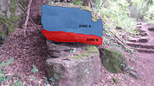
- Question 1 : Quelle différence principale y a t'il entre la zone A et la zone B ? Déduisez en laquelle est du grès vosgien et laquelle est du conglomérat principal.
- Question 1 : What main difference is there between zone A and zone B ? Deduct which is the Vosges sandstone and which is the main conglomerate .
- Question 2 : Observer la taille moyenne des plus gros débris à l'origine de la partie A. A partir des informations du descriptif de la cache, déterminer la vitesse maximale moyenne du cours d'eau ayant conduit au dépôt des sédiments de cette formation.
- Question 2 : Observe the average size of sediment behind part A. From the description of the cache information, determine the average velocity of the stream leading to the deposition of sediments of this formation.
Point 2 : N 48° 31.979 E 007° 26.293
Vous voici au sommet du Geissfels, observons la partie sommitale appartenant au conglomérat principal.
Here you are at the top of Geissfels, observe the top part belonging to main conglomerate.
- Question 3 : En fonction de la forme des plus gros éléments du conglomérat, déduisez-en son type.
- Question 3 : Depending on the form of the biggest components of the conglomerate, what is this type?
Sur le côté Est de l'émergence, approchez-vous du gros minéral entouré en rouge sur la photo WP2.
On the eastern side of the rise, approach near the large sedimentary block circled in red on the photo WP2.
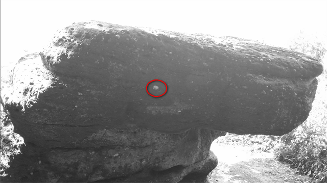
- Question 4 : Quel est son diamètre ?
- Question 4 : What is its diameter ?
Vous pouvez vous loguer sans attendre notre confirmation,
mais vous devez nous envoyer les réponses en même temps soit par mail via notre profil (
fafahakkai), soit via la messagerie geocaching.com (Message Center).
S'il y a des problèmes avec vos réponses nous vous en ferons part.
Les logs enregistrés sans réponses seront supprimés.Une photo de vous ou de votre GPS en Noir & Blanc devant le panorama depuis le rocher du Geissfels sera la bienvenue, mais n'est pas obligatoire
You can log this cache without waiting for our confirmation, but you must send us the answers at the same time, by e-mail via our profile (fafahakkai) or by the system of Message Center of geocaching.com.
If there is a problem with your answers we will notify you. The logs recorded without answers will be deleted.
A picture of yourself or your GPS in Black & White with the view from the front of the rock of Geissfels would be welcome but is not mandatory.
Rappel concernant les « Earthcaches »: Il n'y a pas de conteneur à rechercher ni de logbook à renseigner. Il suffit de se rendre sur les lieux, de répondre aux questions ci-dessus et de nous renvoyer les réponses.
Reminder concerning "Earthcaches": there is neither a container to look for nor a logbook to sign. One need only go to the location, answer to the differents quiestions and send us the answers.