Français
L’entité paysagère du puy de Mur (plateau et flanc) comprend un vaste espace d’environ 2 790 hectares à cheval sur les communes de DALLET, MEZEL et VERTAIZON
Le Puy de mur est connu pour la présence d’une carrière d’extraction de basalte mais également aujourd'hui par le classement en espaces naturels sensibles d'initiative locale (ENSIL). Cette labellisation implique la mise en place d’un plan de gestion quinquennal dont la réalisation a été confiée en 2012 au Conservatoire des Espaces Naturels d’Auvergne.
Un sentier de randonnée a été aménagé « Autour du puy de Mur ». Tout au long du parcours vous pourrez découvrir
- Six panneaux thématiques sur : la faune, la flore, le patrimoine rural, l’archéologie, la géologie et les milieux naturels,
- Deux tables paysagères au sommet du puy de Mur
http://www.muresallier.com/system/download_files/93/files/original/Carte_pour_site_internet.pdf?1400671742
Les basaltes sont utilisés dans la construction et dans la statuaire. Les basaltes, en raison de leur texture fine et isotrope, sont également valorisés comme granulats de forte compacité et de grande résistance mécanique. Certains peuvent être utilisés pour la réalisation du ballast des voies ferrées. La laine de roche est obtenue à partir de basalte ou de roche diabase analogue au basalte, via un procédé de fusion (dans un cubilot dans lequel on ajoute des fondants et du coke pour le porter à 1500 °C) et d'extrusion.
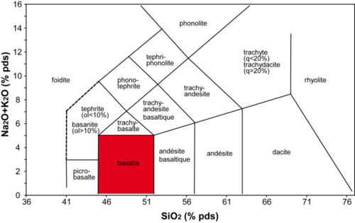
Le basalte est une roche volcanique sombre (mélanocrate de composition basique) généralement peu évoluée par rapport aux magmas issus directement du manteau terrestre. Elle est caractérisée par une teneur en SiO2 comprise entre 47 et 52 % pds et une teneur en alcalins comprise entre 0 et 5 % pds environ (voir graphique).
Pour valider cette earth cache, vous devez répondre aux questions suivantes réparties sur 3 étapes :
Panneau pédagogique N45° 46.489' E3° 15.347'
1-Quelle est la date de fin de l’éruption qui a constitué le puy de mur ?
2-Le relief du Puy de mur a été formé par un phénomène expliqué sur le panneau. Citer ce phénomène ?
3-Le Puy de Mur constitue une zone d’infiltration importante qui alimente 9 sources d’eau. L’une d’entre elles est en photo sur le panneau pédagogique. Citer son nom et vous rendre ensuite à celle-ci distante d’environ 250m.
Source d’eau N45° 46.481' E3° 14.978'
4-Quelle est la date inscrite sur le socle en béton datant l’année de réhabilitation du bassin
Sommet du Puy de Mur N 45° 45.913 E 003° 15.002
5-(option) Du sommet vous pourrez découvrir un superbe panorama à 360° sur la faille de Limagne et sur le front de taille de la carrière. Transmettre une photo de vous et de votre GPS à partir des tables d’orientation.
English
Located on the right bank of the Allier, the Puy de Mur is an isolated topographic feature of the large site that is the chain of Domes. Like its neighbors the Puy Saint-André and the Puy Saint-Romain further south, it raised its mark on the territory of Clermont and is characterized by the view it offers walkers to 360 °.
English
The landscape entity Puy de Mur (plate and flank) includes a vast area of about 790 hectares straddling 2 in the towns of DALLET, MEZEL and VERTAIZON
Le Puy de Mur is known for the presence of a basalt quarry extraction but also the rankings today in sensitive natural areas of local initiative (ENSIL). This label implies the establishment of a five-year management plan whose implementation was entrusted in 2012 to the Conservatoire d'Auvergne Natural Areas.
A hiking trail has been laid "Around the Puy de Mur". Throughout the course you will discover
- Six thematic panels on: fauna, flora, rural heritage, archeology, geology and natural environments,
- Two tables landscape at the top of the Puy de Mur
http://www.muresallier.com/system/download_files/93/files/original/Carte_pour_site_internet.pdf?1400671742
The basalts are used in construction and statuary. Basalts, because of their fine and isotropic texture, are also valued as aggregates of high compactness and high mechanical strength. Some can be used for carrying ballast railways. Stone wool is obtained from basalt or diabase rock similar to basalt, via a melting process (in a cupola furnace comprising adding fluxing agents and coke to bring it to 1500 ° C) and extrusion.
Basalt is a dark volcanic rock (mélanocrate basic composition) generally unsophisticated compared to magmas directly from the earth's mantle. It is characterized by a SiO2 content of between 47 and 52 wt% and an alkali content of between 0 and about 5 wt% (see chart).
To validate this earth cache, you must answer the following questions divided into 3 stages:
Educational panel N45 ° 46.489’ E3 ° 15,347 '
1-What is the end date of the eruption that formed the puy wall?
The 2-Puy wall Relief was formed by a phenomenon explained on the panel. Quote this phenomenon?
3 Le Puy-wall infiltration is an important area that supplies 9 water sources. One of them is pictured on the educational panel. Mention his name and then go to it distance of about 250m.
Water source N45 ° 46 481’ E3 ° 14,978'
4-What is the date on the concrete base dating from the year rehabilitation of the basin
Top of the Puy de Mur N 45 ° 45,913’ E 003 ° 15.002’
5- (Optional) From the top you will discover a panoramic 360 ° view over the Limagne Fault and the size of the quarry front. Beam a photo of you and your GPS guidance from the tables.
(source wikipedia – géowiki - site communauté de commune mur es allier)